Create Concentric Circle Map
A concentric circle map is a map with a series of circles of varying radii based on the same center point. Users create concentric circle maps for multiple applications:
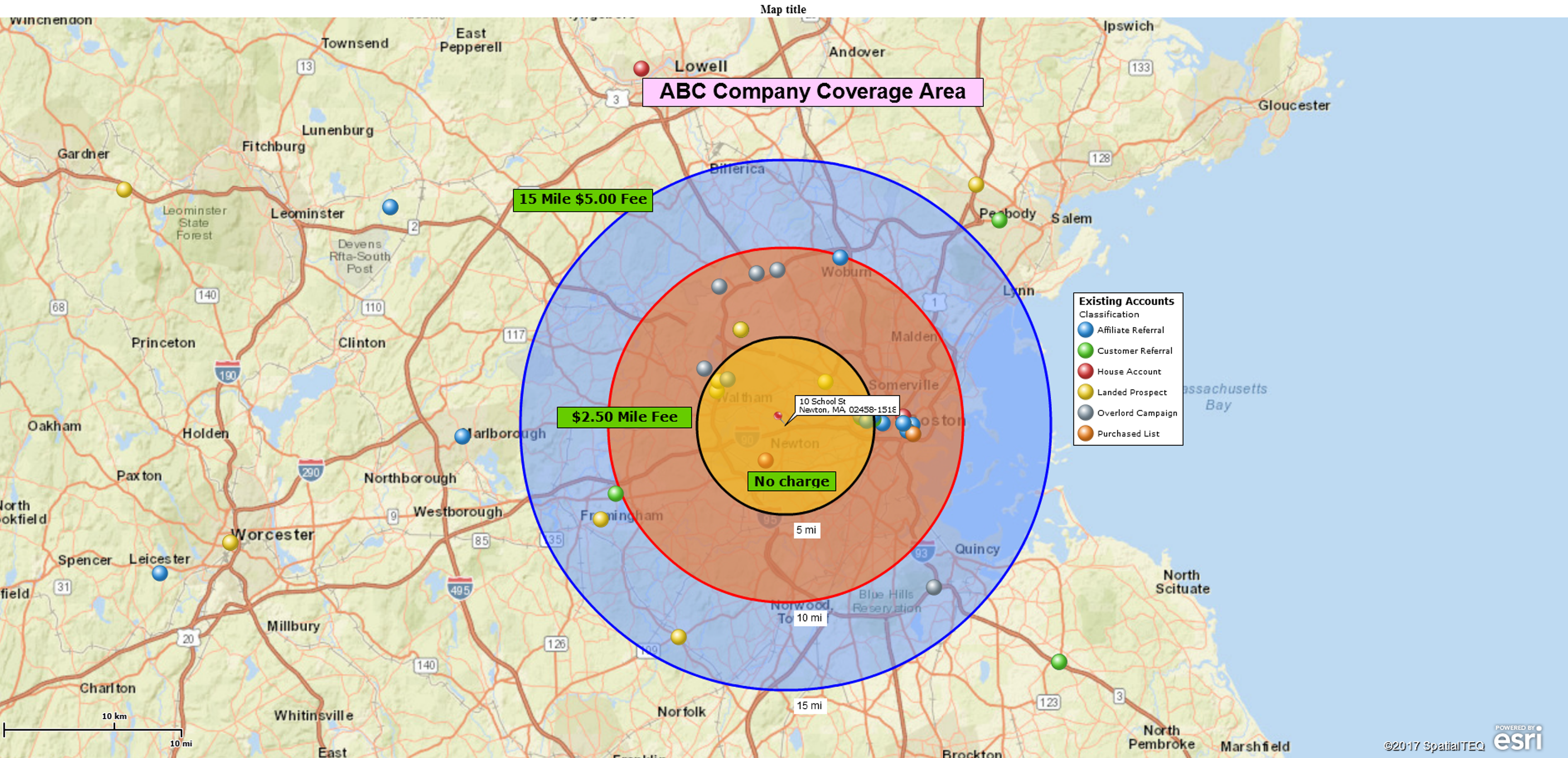
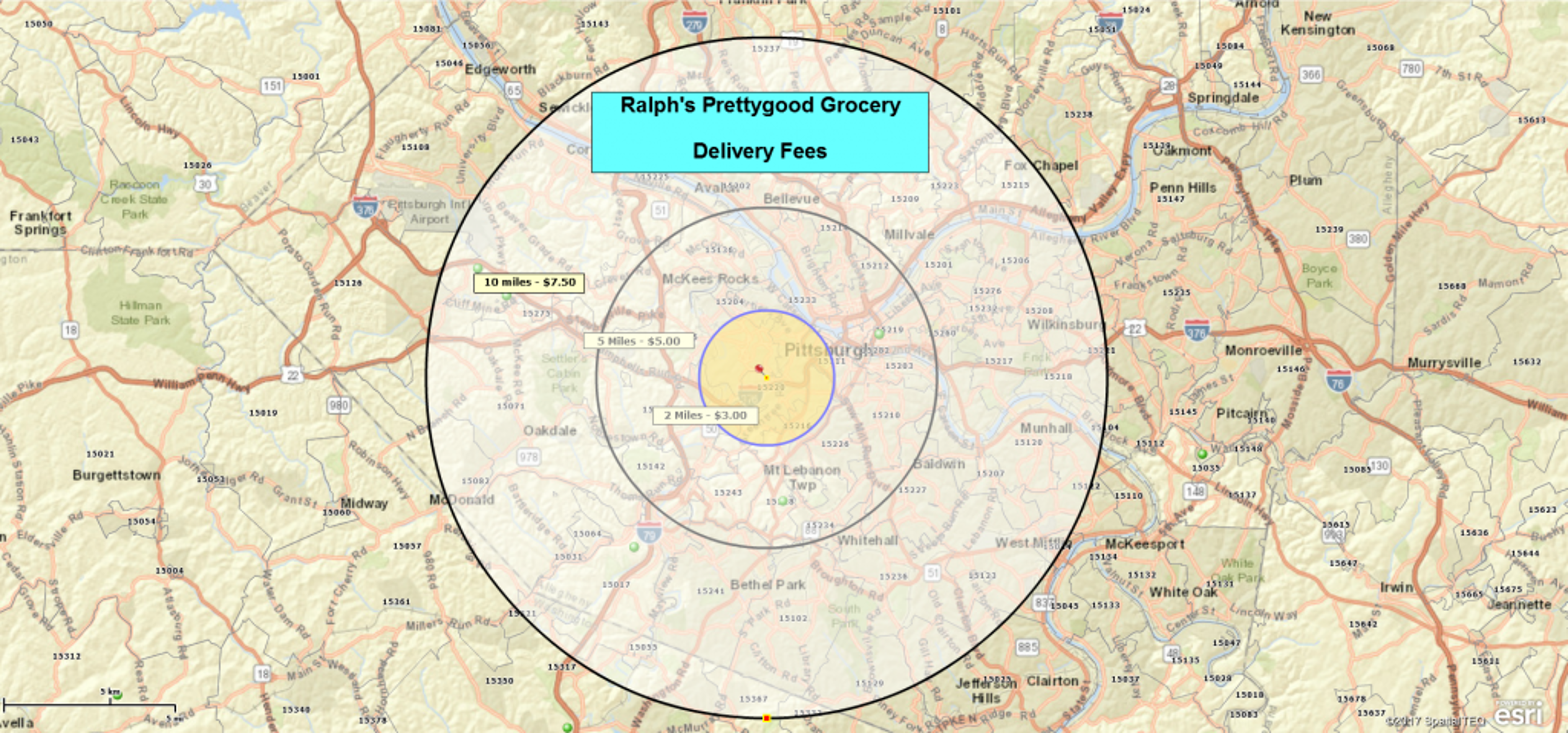
- Concentric circles are often used to represent delivery areas. The circle or radius search areas are often derived from driving times and distances from a central location and are organized into rings. Some concentric circles maps define the costs/prices to ship from an origin point to destination points within each ringed area.
- Demographic data associated with concentric circles can describe the potential market that exists in each band. Often those market circles are determined by driving times and driving distances.
- Concentric circles could be used to demographically define sections of urban areas or cities based on their distance from a city centroid point.
- Concentric circle maps can also be helpful as visual bands that define distance ranges from a central point. A map viewer may be able to quickly estimate distances when looking at concentric circle maps based on standard spaces between bands.
MapBusinessOnline includes a “Radius Tool” for creating radius maps or maps with circles. Typically, a radius map means drawing a circle on top of a ZIP code layer for visual purposes or extracting the defined areas list of ZIP codes. This could be referred to as a Zip Code Map.
Business mapping software users often create maps with variations on a radius map or circle map. Sometimes they want many circles made at different points across the map simultaneously. Multiple radii on the map functionality are available for MapBusinessOnline Pro subscribers.
Concentric Circles Around One Point
Concentric circles or radii are different than multiple circles. Concentric circles are more than one circle around one central point. Multiple circles would be many circles around many points.
Map users like concentric circles for a bunch of reasons. It could reflect a sales territory, an enterprise strategic plan, or an emergency buffer zone. Your map could be a drive time area with demographic estimates of how many people may attend the school fair next week or a block-by-block political polling campaign.
Often, these circles represent gradations of service based on distance from a central point:
- Delivery fees can be noted as Map Text related to each circle. The price usually increases in proportion to the distance from the center point or warehouse location. For example, $5.00 for deliveries of 10 to 20 miles and $7.50 for deliveries of 21 to 30 miles. And so on.
- Medical coverage areas with gradations of clinician coverage based on travel times. The time to travel to each circle could be generalized—for example, 15 minutes at 5 to 10 miles and 30 minutes at 11 to 25 miles.
- Retail store projected customer travel times. An outer circle for 45 minutes, a middle circle at roughly 30 minutes, and an inner circle at 15 minutes.
These concentric map images can be shared interactively as a shared web map or as static files on a website, or included in a pamphlet. The user decides how to communicate their concentric circle map message.
How to Create a Concentric Map Circle
- Place a center point on the map either by keying in an address in the Address Bar or simply dropping an issue with the Draw Tool’s Location button. You could also begin your concentric circle on any point you’ve imported as part of a dataset. In any case, select your concentric circle center point, and the Mini Tool Bar appears right next to the point.
- On the point’s mini-toolbar select the first button listed – Circle. Insert your first circle’s radius distance
- The Properties box opens up, but you can always click the Properties gear on the mini toolbar to adjust color shade, line thickness, fill, or add text to the circle.
- To start your second and additional circles, reselect the point symbol and repeat the Circle process at a new radius distance. Repeat until you have all the circles required
- Adjust color, fill, and thicknesses as necessary using the Properties gear
- Save your work and share as required
Concentric circles are easy to construct once you’ve got the process down. Filling in the various circle layers is tricky because the wider circle fill will trump the inner circle fill. Experiment to see what fill schemes work best for your map purposes.
Many users will label the various circles in a graduated scheme, perhaps for a delivery charge:
Concentric circles, like other MapBusinessOnline map objects, can be used to query imported data – like customer lists – or as a query/geographic filter for business listing acquisition. For Business Listings, click a circle object and note the Mini Toolbar that is associated with it. You will note the Yellow Pages Book icon with a pair of Binoculars. That’s the tool for assessing business listings. You can use that Business Listings tool to search businesses by industry category (think gas station, variety store, oil refinery) within your selected circle.


