Competitor Territory Mapping
The Benefits of Territory Mapping Software
In any business, true situational awareness requires not just knowing where your customers are, but where your competitors are, too. In fact, the two go hand in hand. To understand your customer base, you need to know how they interact with other businesses in the region — where they shop, what they want and how they get where they need to go.
Competitor territory mapping is a useful tool for strategic planning and market analysis. Regardless of what industry you're in, your business can benefit from an increased awareness of your competition and the customers they attract.
What Is Competitor Territory Mapping?
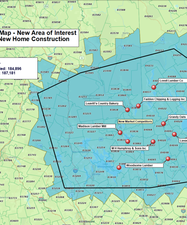
A competitor territory map is a visual representation of the location of your competitors. On its own, it can be a powerful tool for identifying your biggest threats and most lucrative opportunities. However, when overlaid with other information — such as your previous sales records or demographic data from the U.S. Census, it can yield insights that will be extremely useful in big-picture strategic planning.
For example, a competitor research map can show you the local demographics of the neighborhoods where your competition has a significant presence. From there, you can target your marketing specifically to appeal to these groups, eating into their customer base. Alternately, it can show you which types of customers are currently underserved in a region.
Mapping competitors is useful when creating sales territories, in that it helps you assign your strongest team members to areas where their expertise is needed most. It's also a powerful tool for site selection when expanding your business, as it shows you the areas with the most risk — and greatest potential for reward — when planning for a new location.
Working with Competitor Analysis Maps
MapBusinessOnline contains multiple tools for competitor mapping and analysis. Some of the ways you can organize your data include:
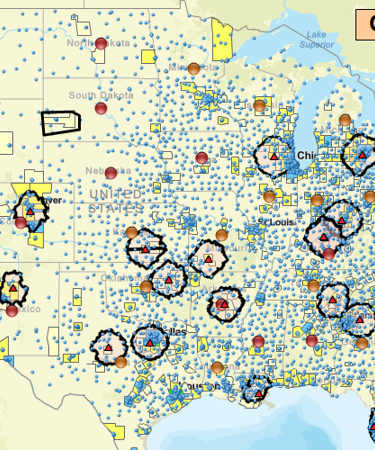
- Heat maps: Heat maps show you areas with a high concentration of competitors — hotter colors mean a more saturated market. They also show you areas that are underserved by businesses in your industry. MapBusinessOnline's heat maps are fully customizable based on a range of metrics and visualization options.
- Radius maps: Radius maps are one of the most useful tools for competitor research. They show you how much of a given dataset is within a specific radius. Use radius maps to map your nearest competitors and their service areas, or find out how many potential customers are located near a given site.
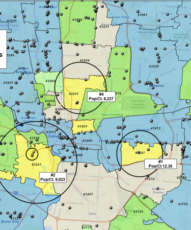
- ZIP code maps: MapBusinessOnline also gives you the option of sales competitor mapping within a specific ZIP code, municipality, census tract or another custom-defined territory. ZIP code maps are great for allocating resources such as sales staff, or getting a clearer picture of where your competitors are and who they serve.
These are just a few of the many competitor mapping features you'll find in MapBusinessOnline. Keep exploring this website to learn more and read detailed case studies. To try out MapBusinessOnline today, sign up for a free trial:
See MapBusinessOnline in Action
Request a demo
Learn How Our Customers are Succeeding with MapBusinessOnline

"MapBusinessOnline has helped my organization visualize our territories in very little time. I created maps that allowed us to see where we are doing well and where we may be struggling. Getting this information has helped us capitalize on our opportunities and build our brand throughout the country."
Elwin Warsh
Strategic Sales Analyst
The Honest Kitchen
The Alternative Board (TED), an advisory board creation service for business of all types and sizes, used MapPoint to import customer locations, create and manage territories, and for visual market analysis. When MapPoint left them high and dry, they began looking for a MapPoint replacement. This process led them to MapBusinessOnline.
Over a period of a few weeks MapBusinessOnline shared several online web demo that showed exactly how MapBusinessOnline would replace and improve upon the mapping technology TED had become used to. The Alternative Board recently renewed their Map Business Online subscription for another year.
The Alternative Board

Prison Fellowship — Prison Fellowship® trains and inspires churches and communities-inside and outside of prison-to support the restoration of those affected by incarceration. PFM uses MapBusinessOnline Team Edition to create a variety of maps that track the placement of constituents and describe the demographic background of placement areas for further study and understanding.
"We love MBO, especially the ability to share maps with non-license holders for viewing!"
Business Manager
Prison Fellowship

Popular MapBusinessOnline features
Design and visualize sales territories

Use our sales territory mapping software to create sales territories by ZIP code, county, or state. Aggregate demographics and sales data by territory. Search business data inside sales territories. Highlight territory overlap.
Build fast map visualizations of your business data

Map business data from various sources by street address, city name, ZIP code, or latitude and longitude. Plot 250,000 or more locations on a map at once. All you need to start is a spreadsheet with business data.
Display business data against demographic maps

Categorize geographic areas by population or household income. Explore new markets, business patterns, or social trends against color coded Census maps for business and competitor analysis.
Draw custom graphics and annotate maps

Draw circles, rectangles, polygons, and lines. Choose from a selection of line styles and fill colors. Identify map locations with text. Draw market areas and sales territories. Customize your business map.
Print large format map views

Print large maps to use in presentations and project plans. Save maps as PDF files to print as large as 60” x 60” customer maps. Supports multiple pages option to use your home or office printer for large wall maps.
Share business maps

Create interactive maps and share with friends, colleagues, dealers, customers, prospects or vendors. Share territory maps. Email saved JPEG and PNG files or embed map files in PowerPoint presentations. Includes PDF export for larger print formats.
Search data spatially with radius maps

Explore your data within circle or polygon areas. Organize search results into marketing lists or market areas. Export ZIP code demographics, territories, or marketing lists in Microsoft® Excel spreadsheets.
Create state or regional map views

Filter map view to show only selected states or regions. Create local maps that display only certain counties or ZIP codes from your market area or within a radius.
Create maps for various map regions

Make maps for US and Canada. Design sales territories and export demographic data for all regions supported. Streets and aerial maps are available for entire World.


