Drive Time Analysis


Discover What’s Possible with Drive Time Analysis
- Create realistic drive-time polygons from any location, following real road networks and taking into account the hour of day and day of week.
- Create sales, service, or franchise territories around office or start-of-day locations for service techs and sales reps.
- Find customers, suppliers, or competitors within a specified driving distance of a store or an event.
- Conduct trade area analysis leveraging the included demographic data and business listings.
- Select a new site location by comparing drive-time based trade areas and demographic profiles for potential and existing locations.
- Identify and reduce travel time inefficiencies in existing service and sales territories.
- Share interactive maps with colleagues for aligned planning.
Create Realistic Drive-Time Polygons

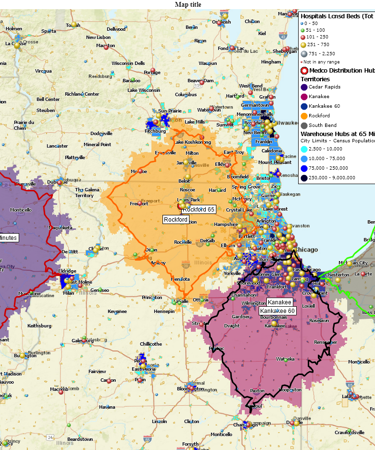
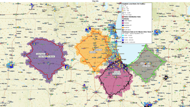
Create single or multiple drive-time polygons from any location. Visualize how far customers, staff, or deliveries can travel within set time frames. MapBusinessOnline generates polygons that follow real road networks and take into account the hour of day and day of week, going beyond simple circles to show realistic coverage.
Create Sales, Service, or Franchise Territories

Compile ZIP codes within the drive-time polygons into sales, service, or franchise territories. Build drive-time territories around office or start-of-day locations for service techs and sales reps. Assign customers and accounts to the nearest location, ensuring territories are compact, fair, balanced, and travel efficient. Visualize territory areas color-coded by demographics or sales activity. Quickly adjust when coverage gaps, overlap, or inefficiencies appear.
Find Customers, Suppliers, or Competitors within a Specified Driving Distance

Filter your data — customers, sales, or business listings — by who falls inside which drive-time polygon. Find the nearest store or pick-up locations. Identify the suppliers within the closest proximity of business facilities to ensure timely deliveries and reduce transportation costs. Plan prospecting activities within a specified territory.
Conduct Trade Area Analysis

Use customer driving time to retail stores to define the trade area. Analyze population and other demographic attributes of the area for better marketing and sales planning. Identify areas with matching demographic profile within a specified driving distance of a store or facility – and replicate successful markets. The rich demographic data and business listings are included with the subscription.
Select and Compare New Sites for Expansion Planning

Evaluate potential sites by comparing reach within 10, 20, or 30 minutes. Identify trade areas with optimal population densities, median household income, and customer driving time. Determine the most strategic location for a new store, office, or service hub, considering customer access and market opportunities.
Identify and Reduce Travel Time Inefficiencies

Use drive-time polygons to visualize realistic travel times for your service and sales teams. Quickly see whether existing territory boundaries extend beyond practical drive-time limits. Adjust territories or service areas to minimize travel time, improve coverage balance, and keep your teams operating efficiently.
Share Interactive Drive-Time Maps

Share your analysis with colleagues or partners in multiple ways: collaborate on maps with other MapBusinessOnline subscribers, share interactive read-only maps in the free MapBusinessOnline Viewer, or export high-resolution map images. Keep your sales, operations, and planning teams aligned on service coverage, territory assignments, and expansion strategies.
See MapBusinessOnline in Action
Request a demo
You’re in Good Company

"We quickly grew from a one location small-business to a franchised business with 8 locations across the country. After selling our first few franchises, I realized I needed a way to map out a potential franchisee's territory. Initially I just wanted to be able to create territories based on drive time from an address, which is easy to do with MapBusinessOnline. What I didn't know I needed was the ability to export census data, including information on other dog related business, which is very helpful!"
Steve Sentner
Co-Owner
Paw & Order Dog Training
MVP Sports Clubs is a sports and health facility management and development company with operations in Central Florida and West Michigan. MVP uses MapBusinessOnline to construct demographic map profiles of a radius surrounding each of their many sports clubs. Such market analysis helps MBO users develop a better understanding of their business which makes strategic planning more effective.
"MBO users develop a better understanding of their business which makes strategic planning more effective."
Mark Hope
Business Manager
MVP Sports


"MapBusinessOnline has played a major role in helping us to expand. It has helped us successfully map out our territories so that we know where we are and where we can be. With a clear picture of where we are, it has helped make it easier to locate available territory for our new Franchisees. MapBusinessOnline has even helped us keep our guarantee and carry out its promise for a five mile protection radius for each Franchisee. MapBusinessOnline has not only given us a map of where we are now, but it has also given us a map for our future."
Sine Schirmer
Franchise Support Department Head
The Tutoring Center Franchise Corp


