Build Interactive ZIP Code Maps

and Create Your First Interactive ZIP Code Map – Take a FREE Trial
ZIP codes are a critical map layer for conducting analysis in business mapping software. Originally created by the U.S. Postal Service to improve mail delivery, ZIP codes have become a meaningful geographic unit used by business to analyze markets, plan marketing campaigns, and define sales territories.
Businesses and non-profit organizations use interactive ZIP code maps for a variety of real life applications:
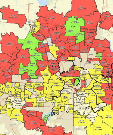
- Market Analysis and Campaign Planning - Marketing managers use ZIP codes and associated demographic information to define successful markets and replicate these successful markets in untried areas. Because the Census Bureau publishes demographic territories by ZIP codes, these relatively local geographic units have become a standard for market area definition.
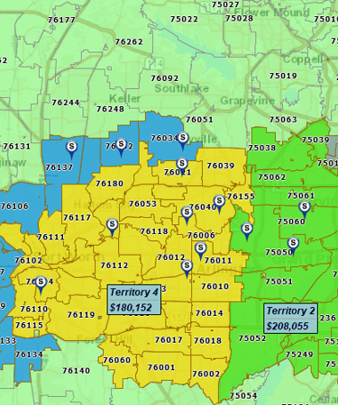
- Sales Territory Mapping - Sales organizations use territory maps to define areas of responsibility and track progress against goals. ZIP codes are the most common base map layer applied to sales territory mapping. ZIP codes are a manageable and easily comprehended building block for assignment to a sales person. Often a sales person's territory is related to where they start their day and limited to a certain driving time. Thus, a territory could be just a half dozen ZIP codes.
- Business Expansion Planning - ZIP codes are often applied to expansion planning. Hospital systems or retailers will gauge a new operating area viability based on the number of businesses, potential patient population, and demographic breakdown of the surrounding ZIP codes. It may be a 50-mile spread or a fifteen-minute drive time, but the analysis will focus on ZIP codes.
- Communicating Service Coverage Areas - Businesses communicate their coverage areas through interactive web maps or shared map images. And most often those coverage areas reflect ZIP codes and towns.
- Field Staff Coordination - Field staff management can get expensive and customer focus is critical. Interactive ZIP code maps are used to define accountable areas and define driving time allotments.
- Retail Drive Time Analysis - Smart retailers are always interested in the demographic profile of surrounding ZIP codes. They'll use this information to develop product sales, to segment marketing campaigns and periodical advertising. ZIP code driving times may be important for traffic estimates and delivery promises.
MapBusinessOnline's ZIP code map layer can be turned off and on. ZIP codes can be color shaded to reflect areas of interest, territories, coverage areas or to simply highlight a ZIP code or two. ZIP code boundary lines can be adjusted by color and thickness interactively. And ZIP code labels can be appended by up to five additional data fields. Append your ZIP code labels with demographic data, calculated data or your own imported sales or operational data. Export lists of ZIP codes for use in 3rd party applications.
ZIP code data in MapBusinessOnline is automatically updated quarterly to reflect US Postal Service changes. A complete list of all types of ZIP codes (boundary and point types) is included in the application assuring any legitimate ZIP can be queried, filtered and exported for use on your business.
MapBusinessOnline offers a variety of methods for creating and sharing interactive ZIP code maps. So, whether you need advanced, hierarchical sales territory management maps or you just need a simple list of ZIP codes now is the time for you to leverage the power of interactive ZIP code maps for your business.
See MapBusinessOnline in Action
Request a demo
Popular MapBusinessOnline features
Design and visualize sales territories

Use our sales territory mapping software to create sales territories by ZIP code, county, or state. Aggregate demographics and sales data by territory. Search business data inside sales territories. Highlight territory overlap.
Color code maps by ZIP code, county, or state

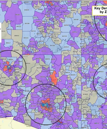
Import business data by ZIP code to show it geographically. Create colorful maps for business analysis that connect real Census data to locations on the ground.
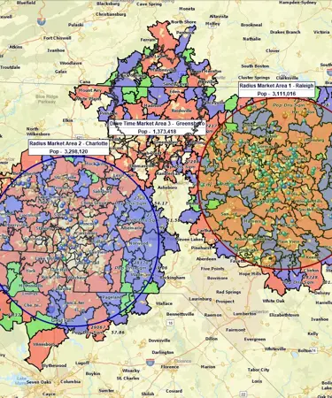
Search data spatially with radius maps

Explore your data within circle or polygon areas. Organize search results into marketing lists or market areas. Export ZIP code demographics, territories, or marketing lists in Microsoft® Excel spreadsheets.
Display business data against demographic maps

Categorize geographic areas by population or household income. Explore new markets, business patterns, or social trends against color coded Census maps for business and competitor analysis.
Print large format map views

Print large maps to use in presentations and project plans. Save maps as PDF files to print as large as 60” x 60” customer maps. Supports multiple pages option to use your home or office printer for large wall maps.
Search business data in full-featured tabular view

Search your data records by business name. Sort data view by any variable. Filter data by custom criteria. View search results on map.
Share business maps

Create interactive maps and share with friends, colleagues, dealers, customers, prospects or vendors. Share territory maps. Email saved JPEG and PNG files or embed map files in PowerPoint presentations. Includes PDF export for larger print formats.
Create state or regional map views

Filter map view to show only selected states or regions. Create local maps that display only certain counties or ZIP codes from your market area or within a radius.


