
All businesses have coverage areas. From lemonade stands to wireless phone services, all businesses provide or sell services over a specific coverage area. Many companies turn to business mapping software to display these critical areas of interest.
Coverage areas are important because they describe where customers can expect to receive services. A home care agency can demonstrate how vital coverage area maps are. By sharing a home care agency coverage area map for potential home care patients, families can tell at a glance if the agency is suitable for their loved ones. Care agency assessments could be even more critical for seniors in the era of COVID-19.
In addition to medical regions, coverage maps are great for defining areas of sales accountability, delivery zones, and technical service areas.
Create the Coverage Area
MapBusinessOnline provides a variety of ways to create a coverage area map. The two most direct ways to achieve a coverage area map are:
- Create a shaded area on the map by importing a spreadsheet that lists the coverage districts
- Manually select administrative districts on the map and then label them as a covered area or territory
Coverage areas are usually defined by groups of states, counties, or ZIP codes. Usually, a business understands its coverage area is based on ZIP codes or Counties. MapBusinessOnline can also enable shaded areas based on city limits, Census Tracts, school districts, and even Metropolitan Statistical Areas (a Census-defined market unit).
Learn More About Coverage Area Maps Now
A Coverage Map Example
Let’s assume that a business, Swizzle Sticks Are Us, has a coverage area of counties in Cincinnati, OH. A location-based spreadsheet is managed by one of the sales managers.
For that spreadsheet to be converted to a coverage area map based on counties, it will need at least two columns; one column for the county name and one for the state. Only one column would be necessary if that area were based on ZIP codes. That’s because ZIP code numbers are unique – there are never duplicate ZIP codes. Counties are not unique. There are many US counties with the same name. Examples include:
| County | State 1 | State 2 |
| Essex County | New Jersey | Massachusetts |
| Montgomery Country | Alabama | Pennsylvania |
| Morgan County | West Virginia | Georgia |
Get the picture? A business mapping software must understand county and state to plot the data correctly. The state is always required when working with county data – not just for coverage area maps.
Armed with the correct spreadsheet, a user can upload that data into MapBusinessOnline either as a Point Layer using the Dataset button on the master toolbar or as a territory file using the Create Territories button. The Create Territories approach will save a step in the process, and you’ll end up with a highlight area of counties and a coverage area label. In this way, a coverage area map is also a sales territory alignment map.
The Dataset button places map points on the map at the center of each imported county. Click the button and navigate to your data. Then select the data for import and placement. The MapBusinessOnline map creator can turn off the point layer and color shade the County Layer using the Boundaries button (3-Puzzle Piece icon), highlighting the counties as a shaded coverage area.
My preferred coverage area method uses the create Territories button on the Master Toolbar. The Territories button asks the user to create a map from an Excel spreadsheet. Here the process is slightly more direct. Navigate to your data, import your list of counties, and confirm your County layer and “Territory name.” In the coverage map data, include a column for name and name it something like: “Swizel Stick Coverage Are.” Copy that name down your list of counties.
Coverage areas can also be created manually (with no data importing) by selecting counties or other districts directly on the map using your mouse cursor. If a map user knows precisely which countries they want to display, they can choose a polygon search tool and draw a line through the counties they wish to include. Bring that drawn line back to the beginning to complete the search. MapBusinessOnline will ask you to confirm the list of Counties being searched. You can name that area – Swizzle Stick Coverage Area or something similar.
Using the create sales territory method for coverage area maps makes it evident that a coverage area map is another name for a territory map. That’s OK. Just remember, when your boss is screaming for a coverage map, you can use sales territory mapping software like MapBusinessOnline to build it.
An alternative manual method is to select one county manually with your mouse, then hold down the shift key and select additional counties until your coverage area is complete. This method is excellent if you develop the map from scratch, maybe doing it with a few peers over lunch. “Hey! You forgot Cambridge County, Moriarity!”
This incremental process also highlights how territories and coverage areas can be easily maintained or edited once created. Select a county with your mouse and click the Blue Puzzle piece icon to delete, add or update your coverage area.
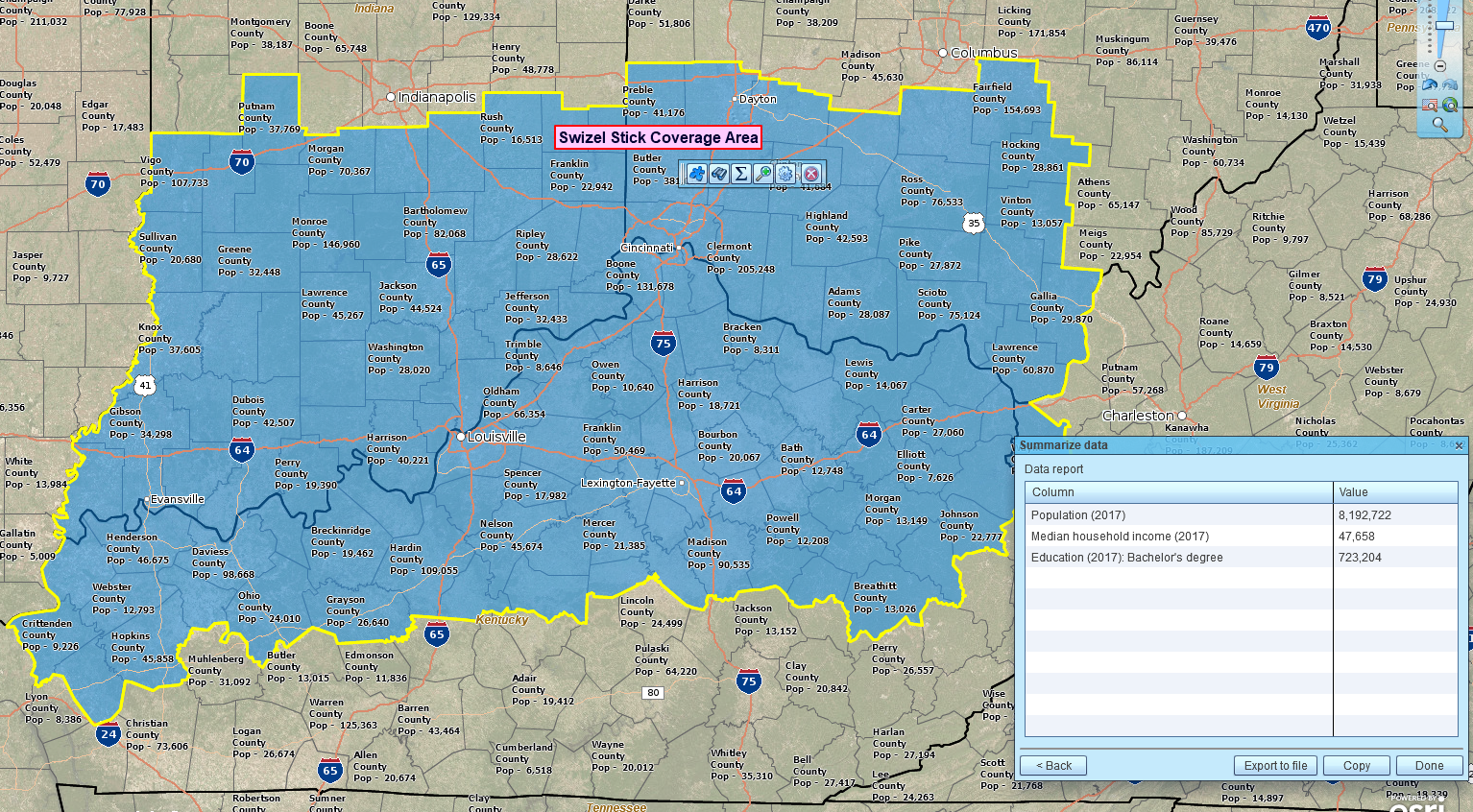
Our Swizel Stick Empire
Search for Business Lists Within Your Coverage Area
Business map users sometimes want to search for business listings within a coverage area. There are multiple reasons to conduct such a search:
- To develop a list of prospect targets for sales contact
- To research a set of business resources for new support programs within your industry
- To conduct due diligence on businesses from a specific industry category
- To perform a thorough potential market analysis
As of December 2018, Map Business Online includes a search and purchase function for business listings. Look for the Yellow Pages Icon with the Binoculars on the master tools bar. Learn more about how to search for business listings here.
Sharing Your Coverage Map
Once you’ve created your coverage map, I recommend saving the map as a template. Name the map file and then choose Template in the dropdown. You’ll find the Template options in the Save Map button.
Saving a map as a template is a smart habit in map production. By saving the map as a template, you can use your coverage map as a base map for other map projects. Open the template and immediately save the map as a My Map file – naming it as a separate project. Now edit as required and save again. Your template is still untouched, and you’ve created another map using your previously saved work as a starter map.
Once your map is to your liking, click the Share Interactive Map button to share the map with your constituents. It’s an easy process. Choose the Public Sharing option and then Share Map. Public sharing will generate a URL that you can share for free for unlimited viewer sessions. Have your non-subscribing map viewer download the Free Map App to access the Map Viewer.
Otherwise, stick with a standard image file, PNG, or Jpeg that may not be interactive but still displays your coverage area. And image file sharing is free too.
Coverage area maps differ from territories in that they quickly communicate the areas where services are provided for the customer—territories display areas of responsibility for service providers. Typically, coverage areas are for external communication, and territory maps are for internal communication.
Some of our customers have used Microsoft MapPoint to build coverage and territory maps. Thousands of former MapPoint map users find MapBusinessOnline the perfect alternative to MapPoint. Similar cost, similar UI, and way better support. They’ve waited in vain for a MapPoint update.
_______________________________________________
Discover why over 25,000 business users log into www.MapBusinessOnline.com for their business mapping software and advanced sales territory mapping solution. The best replacement for Microsoft MapPoint happens to be the most affordable.
To access MapBusinessOnline, please register and download the Map App from the website – https://www.mapbusinessonline.com/App-Download.aspx.
After installing the Map App, the MapBusinessOnline launch button will be in the Windows Start Menu or Mac Application folder. Find the MapBusinessOnline folder in the Start Menu scrollbar. Click the folder’s dropdown arrow and choose the MapBusinessOnline option.
The Map App includes the Map Viewer app for free non-subscriber map sharing.
Please read customer reviews or review us at Capterra or g2crowd.
Contact: Geoffrey Ives at geoffives@spatialteq.com or Jason Henderson at jhenderson@spatialteq.com.