Sales Territory Mapping
Choose MapBusinessOnline Because It is Easy To Use and Has Powerful Territory Mapping Features You Need:
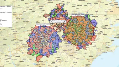
- Create sales territories by easily assigning ZIP codes to territories, or import the assignments from a spreadsheet. Also works with ZIP3, Census tracts, MSA, counties, states, and a mix of these.
- Allow or disallow sales territory overlap. Highlight overlapping areas.
- Apply a variety of color-coding options to territories – both transparent and opaque.
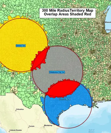
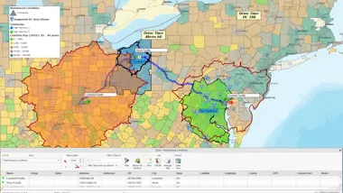
- Create radius or drive time territories.
- Balance sales territories based on Census demographics or imported business variables (such as sales).
- Import sales rep locations and customer location data and visualize against territories.
- Search for contacts and locations of potential customers or competitors in a territory in the provided business listings database.
- Segment data by territory. Export territories and customer assignments by territory.
- Share sales territory maps in varied ways – interactive web maps, map images, or large wall maps.
MapBusinessOnline Sales Territory Mapping features
Create and Edit Sales Territories
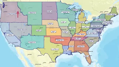
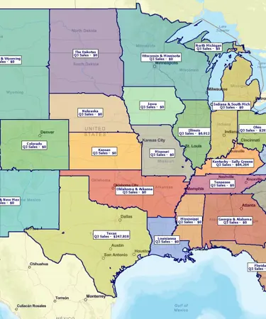
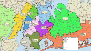
Design and visualize sales territories based on ZIP codes, counties, states, city limits, census tracts, and other geographic layers. Easily assign ZIP codes or other geographies to territories with a few mouse clicks on a map, by radius or polygon searches, or by using the lasso tool. Alternatively, import sales territories from an Excel spreadsheet as groupings of ZIP codes or other geographies.
Identify Territory Overlap
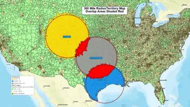
Highlight sales territory overlap. Minimize territory disputes among sales reps and clearly define territory accountability.
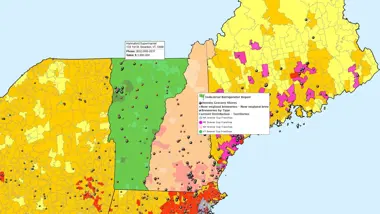
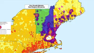
Color Code Sales Territories
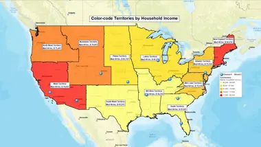
Utilize a range of color coding options, generate heat maps, create thematic maps based on territory demographics, sales, and market potential data. Evaluate team performance by territory.
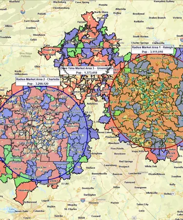
Radius or Drive-Time Territories
Easily convert an area around a location into a radius or drive time-based sales territory. Build territories that reduce driving times. Choose a weekday and time of day for a more realistic calculation based on historical traffic.
Balance Sales Territories by Demographic or Sales Data
Balance your sales territories by workload or opportunity to improve team assignments and cut travel costs. Use your sales data or the Census demographic data provided to color-code or label the territories to be balanced. Adjust territories and see labels update instantly. Easily update sales territories as your resources change.
Build Territory Hierarchy
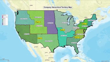
Group sales territories into a hierarchy of regions and divisions to reflect your business structure.
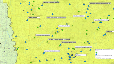
Import Location Data to a Sales Territory Map
Upload the locations of customers, facilities, sales reps, and service staff onto a map. Plot hundreds of thousands of locations using the information already available in your Excel, CRM, or QuickBooks data sources. Build more efficient territories based on locations of your critical assets or customers.
Find Leads or Competitors in a Sales Territory
Search provided business listings database to find contacts and map locations of potential customers or competitors. Adjust your territories to align sales resources with market potential.
Segment Data by Territory
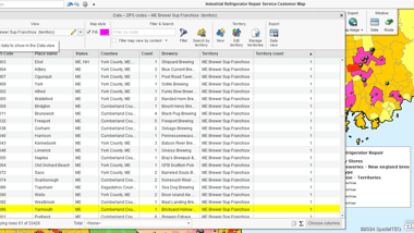
Easily assign customers, prospects, or other location data to your territories. Export territory data along with lists of customers by territory.
Share, Export and Print Sales Territories
Share live territory maps with team members through a free map viewer app, which includes panning and zooming, data search, and export features. Export ZIP codes or customer assignments per territory to CSV or Excel files. Export sales territories as a KML file. Export the map as a JPEG, PNG or PDF file, and print large, high-resolution sales territory maps.
Plan Efficient Routes

Cut travel costs by finding the best routes to reach multiple customers. Optimize the order of stops, given arrival times and durations. Get accurate turn-by-turn directions for your traveling staff.
Complete ZIP Code Coverage

Commercial-grade ZIP code boundaries align sales territories with USPS delivery areas. This is impossible with the Census-based ZCTAs used by other tools. We offer ZCTAs too. As well as point ZIP codes that have no associated area and represent mail delivery points for large facilities.
Import or Export Point ZIP Codes

Don’t miss the point ZIP codes representing mail delivery points for large facilities in your territory areas.
Mix Territory Alignment Layers on One Map

Create sales territories based on a mix of geographical alignment layers. One territory can be defined by ZIP codes, while another can be based on states or counties.
MapBusinessOnline Offers More Than Just Sales Territory Mapping
All-in-one business mapping tool: get all your critical business data on a map, plan logistics operations, generate leads, analyze markets, leverage included demographic data. And more!
User-Friendly Sales Territory Mapping Solution with Responsive Customer Support
Our software solution makes sales territory planning via mapping so easy. In fact, we offer the easiest user interface in the mapping industry.
We back our software with world-class technical support, starting with the initial set-up, configuration, and free trial, and continuing for as long as you remain a MapBusinessOnline customer.
Our territory software is priced to fit even the tightest business or sales department budgets.
If you’re still not sure our sales territory management tool is right for your business, we encourage you to try it out at no cost. Start using MapBusinessOnline with 1-month no-obligations FREE trial today!
You're in Good Company
A leading provider of automated storage and retrieval systems, Kardex Remstar has a multi-layered distribution network in North America. Mapping regional sales territories and sales districts using ZIP codes and states. Kardex Remstar tapped into MBO territory creation services to make the process quick and easy. Detailed ZIP code tables were converted by MapBusinessOnline into multiple maps describing their distribution network, sales coverage by customer segment, and product maps.
"The product is phenomenal and the support even better."
Sales Manager
Kardex

"I use it daily to visualize customers and sales territories, and to plan sales trips. It’s so intuitive."
Jeanne Gazlay
Life Brokerage sales Director
Mutual of Omaha
"You guys are awesome! I used the MapBusinessOnline trial to get promoted to a sales position within my company. I showed them how I would work my territory with great MBO printed maps that showed projected sales dollars by account locations. I got the Job!"
Jeff Krieger
Territory Manager
Mizuno USA


