How to Conduct a Radius Search
A radius search within MapBusinessOnline radius mapping software can provide results for various queries. A radius search places a circle shape on the map.
This is the process to create a Radius object:
- Under Search Tools on the Master Toolbar, select the Circle option.
- Place the Circle center point on the map – any place you desire.
- In the dialogue box that pops up, input the required radius miles.
- Click Search Data.
- Now, you have a choice. You can search any of the presented data fields for spatial search results. Or you can close the map layer search box and continue placing a Circle map object on the map.
Placing a plain old circle on the map provides a way to highlight an area, address, or zone on your business map. Map creators use Radius Searches for other purposes, including:
- Conduct a quick radius search of an area for associated demographic data. Learn more.
- Segment an imported address list of customers or prospects for sales planning and marketing activities.
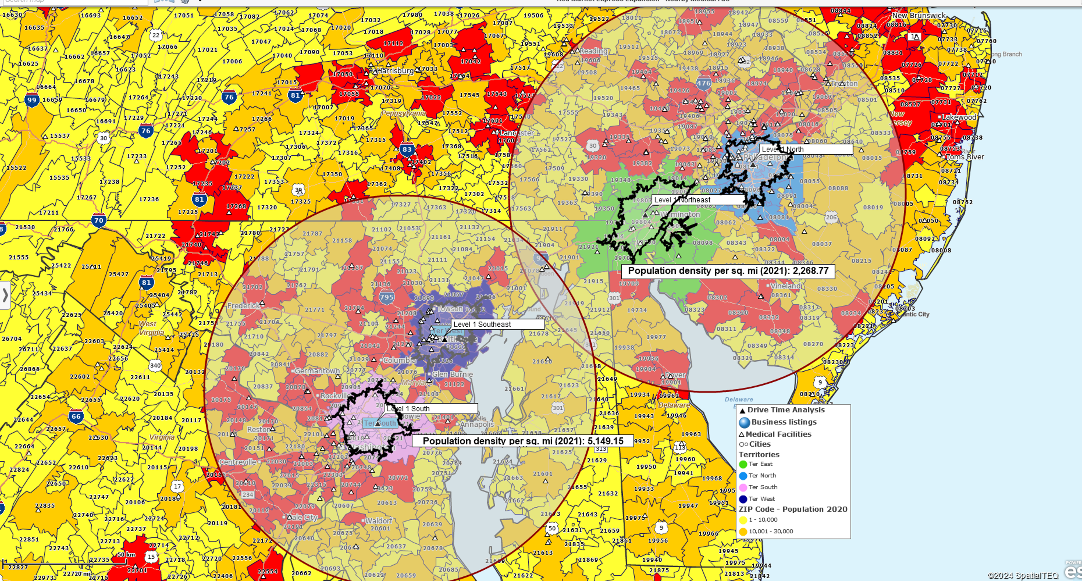
- Conduct preparatory work for sales territory creation, generating a few 25-mile radius territories around a city center or facility.
- Search MapBusinessOnline for business listings by area, industry, or business name.
Search for Data
Any MapBusinessOnline map layer can be radius searched and will present the results in the Data Window. The data window search results can be exported, filtered, routed on, and color-coded on the map. You could also use the map layer search results to create a territory.
Applications for radius searches are many. At its most basic, a circle placed on a business map can be a placeholder, a highlighted area the map creator wants their audience to pay more attention to.
A plain old circle on the map can be filled with any rainbow color. Tools associated with the circle pop up when the object is selected. Feel free to color the circle and adjust the transparency toolbar for a more transparent experience. Thicken and color the circle boundaries as well.
Often circle placements repeat, as the map creator may need to highlight multiple circles on the map. To repeat, re-click the circle icon on the Master Toolbar and drop another point on the map. The map creator can color the various circle fills and boundaries with different colors or the same colors. Boundary thicknesses and colors can also be adjusted.
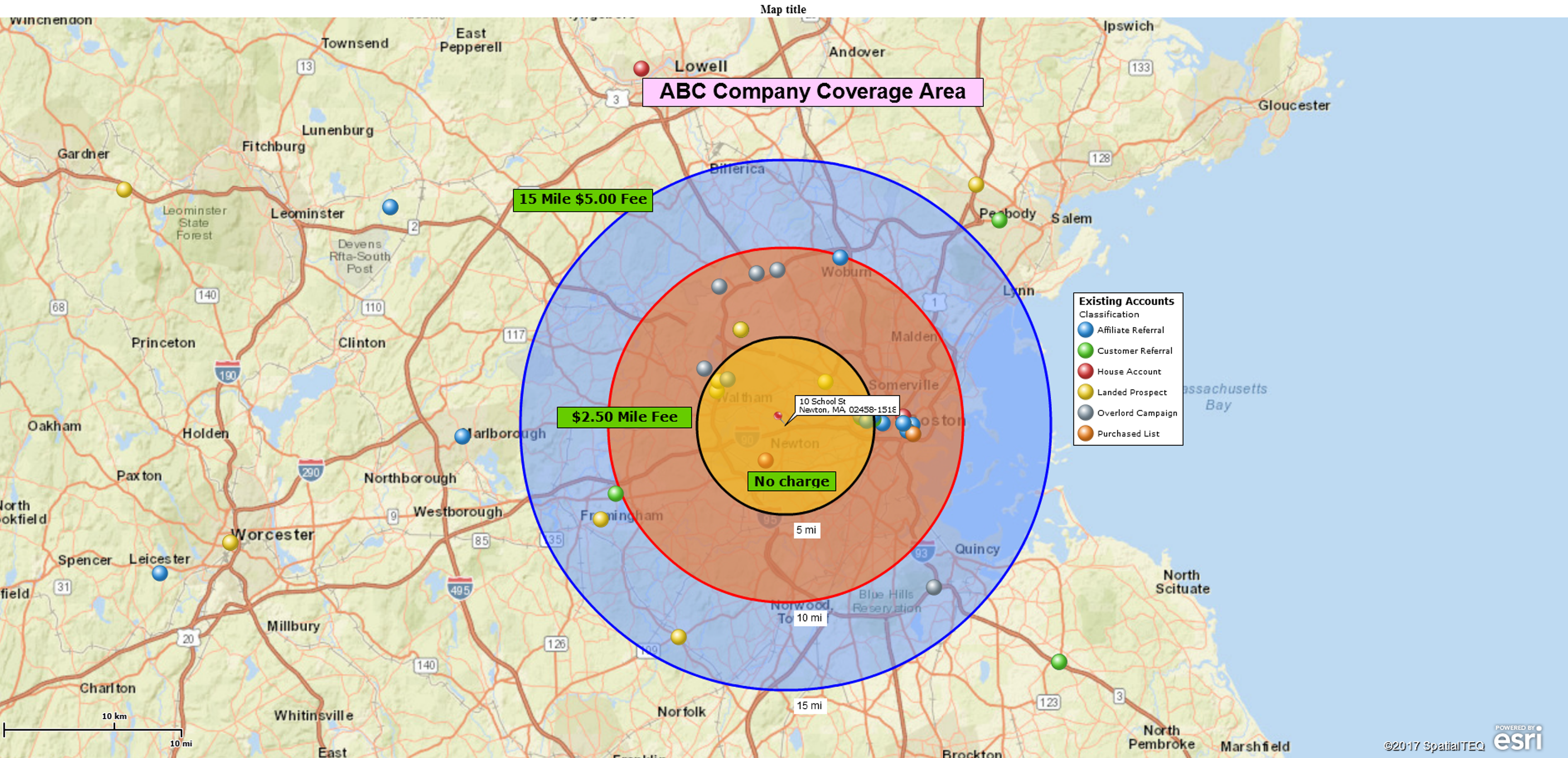
Repeated circle maps can be used to depict coverage areas around service providers. I’ve seen multiple circle objects used to show coverage areas for health insurance organizations, home care agencies, sales organizations, and retail chains.
This circle-in-a-circle or concentric circle approach is excellent for creating delivery or service zones from a central location. Concentric circles are generated from the same center point. Learn more.
Query Demographic, Geographic, and Imported Data
As mentioned in Step 5 of the plot-a-circle process described above, a map user can query the circle area for any of the possible datasets provided by MapBusinessOnline. This is, in essence, a spatial query where the spatial aspect is the area bounded by the circle. Possible data layers available for querying include:
- Imported location data – Data the map creator has imported. Usually, sales figures, customer addresses, or critical resources.
- Map layer objects – MapBusinessOnline geographies such as ZIP codes, Census Tracts, city limits, counties, Metropolitan Statistical Areas, states, and territories.
- Census demographic data – Accessed through the Summarize button, described below.
You should find it easy and intuitive to search for, save and export a dataset in MapBusinessOnline. Queried or searched data layers can be saved as Marketing Lists in the Data Window for further work and export. The Export button is located on the far right of the Data Window Toolbar.
Please note that MapBusinessOnline provides several additional options in the Radius Search dialogue windows:
- A checkbox to find the nearest 100 records (1st page.)
- A checkbox to invert the search – which means search outside the circle – (2nd page.)
- Options for updating the marketing lists are noted on the left of the dialogue page – (2nd page.)
Query Demographic Data
The map creator can query data with any selected map object or, in this article’s case, a circle. As noted above, use the Search option in the map object’s associated menu to query geographic and imported data. But to query demographic data related to the circle area, use the Summarize Option in the associated menu.
- Click the Summarize button.
- The second dialogue page presents a drop-down above two columns. Select demographic data on the Left, scroll down through the library of demographic categories, and choose up to ten subjects.
- Move the desired objects to the Right column.
- Click Next and notice the options for demographic data disposal – Add to the Map or Export.
Currently, the most recent year’s demographic data is a third-party projection. The other years listed are Census Bureau ACS releases. Remember, all demographic data totals are estimates.
Multiple Radius Searches in One Pass
MapBusinessOnline Pro expands the use of multiple radii searches by allowing the user to conduct multiple searches in one pass. This function is listed under the Analysis button on the Master Toolbar.
- Click the Analysis button and select the top option labeled Search and Segment Data from Multiple Centers.
- The second dialogue page provides options for Straight Distance, Driving Time, or Driving Distance radius measures. An option for creating multiple radius circles around up to 200 center points is also presented. Click Next.
- Choose the data layer to search in the Search Data dialogue. Note the Checkbox at the bottom providing the option to create:
- Multiple territories in one pass if you select a map layer.
- Multiple Marketing Lists if you select a dataset layer.
- Click Create.
A radius search or radius map provides one of several spatial forms for highlighting an area or searching for data. These tools are not complex, but they are powerful.


