MapBusinessOnline Features
MapBusinessOnline offers a complete array of business mapping software features designed to support your business needs geographically. And as a cloud-based service you simply log-in from any computer to access your maps. Software and data updates occur quarterly. MapBusinessOnline runs on Windows and Mac OS. We offer many business map layers in addition to detailed street map.
Let us know if there are features, you’re interested in, that we do not offer. We will gladly consider adding your requests to our feature roadmap. MapBusinessOnline development is inspired by our customer requests. We are building software for customers!
- No Daily Plotting Limits - Unlike other cloud-based mapping products, MapBusinessOnline applies no daily plotting limits.
- Automatic Software & Data Updates - Maps, data, and software updates occur automatically!
- The Most Advanced Business Mapping Feature set for the Lowest Price – Go ahead and compare!
U.S. maps: Standard plan $500.00/year, Pro plan $900.00/year
Business lists for market analysis & sales planning

Compile lists of business & contact records in support of sales and marketing campaigns using MapBusinessOnline. Build lead gen lists, conduct market potential analysis, and competitor research.
Build fast map visualizations of your business data

Map business data from various sources by street address, city name, ZIP code, or latitude and longitude. Plot 250,000 or more locations on a map at once. All you need to start is a spreadsheet with business data.
Design and visualize sales territories

Use our sales territory mapping software to create sales territories by ZIP code, county, or state. Aggregate demographics and sales data by territory. Search business data inside sales territories. Highlight territory overlap.
Perform market analysis for multiple sites

Search & segment data from multiple centers. Generate market area profiles. Find nearest store or pick up locations. Batch calculate distances, as well as driving times to multiple locations. Aggregate demographic data. Enrich a dataset with demographic or geographic variables.
Import your data from variety of data sources

Load your data from Spreadsheets, text files, CRM, ERP, accounting packages, or POS systems. Connect to a custom data source with SDK.
Share editable maps with your sales force

Control shared business maps’ access at team or individual levels. Encourage team collaboration through shared sales territory and customer maps. Improve communications within your sales force through clear business maps.
Plan customers visits with optimized routing

Use maps to identify customers within a radius or polygon. Optimize visits sequence and generate turn-by-turn driving directions. Reduce travel costs. Improve ROI and productivity.
Visualize business data on map with various symbols

Assign specific symbols, colors, and sizes to your data points on map. Choose from a wide variety of symbols or create your own. Visually define customers and prospects across multiple locations using symbols color coding.
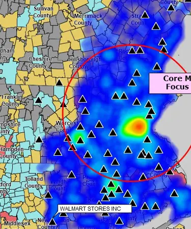
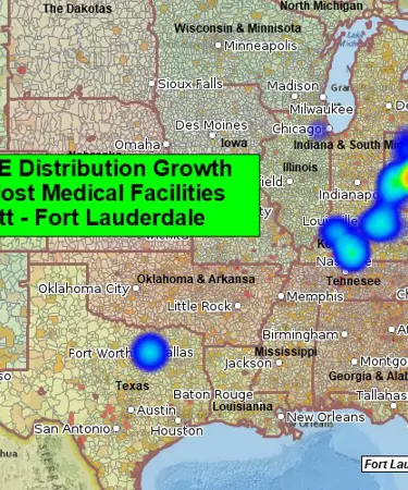
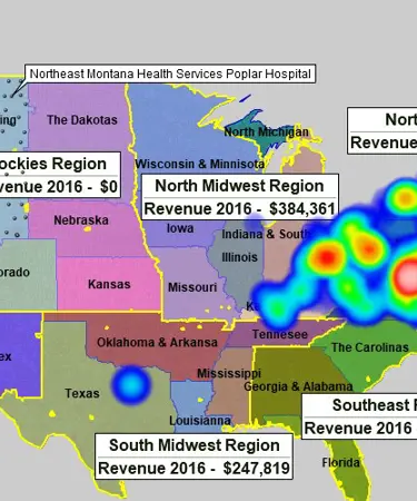
Emphasize customers density with heat maps

Highlight market areas that generate more business. Visually compare map areas for business potential. Select from a variety of heat map colors and options.
Color code maps by ZIP code, county, or state

Import business data by ZIP code to show it geographically. Create colorful maps for business analysis that connect real Census data to locations on the ground.
Illustrate business data on map with charts

Graphically depict your business data on a map using pie or bar charts. Use charts to show sales by product, invoices due vs. paid, products ordered vs. shipped, and sales by customer demographics.
Search data spatially with radius maps

Explore your data within circle or polygon areas. Organize search results into marketing lists or market areas. Export ZIP code demographics, territories, or marketing lists in Microsoft® Excel spreadsheets.
Use maps to create marketing campaigns

Search potential customers spatially and by demographics. Organize search results into marketing lists. Export marketing lists in Microsoft® Excel spreadsheets.
Display business data against demographic maps

Categorize geographic areas by population or household income. Explore new markets, business patterns, or social trends against color coded Census maps for business and competitor analysis.
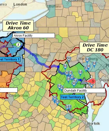
Add drive time polygons to your market analysis tools

Create drive time polygons to identify actual market areas by hour of day and day of week. Explore your data within drive time areas. Improve direct mail campaigns.
Draw custom graphics and annotate maps

Draw circles, rectangles, polygons, and lines. Choose from a selection of line styles and fill colors. Identify map locations with text. Draw market areas and sales territories. Customize your business map.
Select one of many carefully designed base maps

Plot your business locations or sales territories on top of recent base maps crafted by the best cartographers from Esri – the leader in mapping industry: satellite imagery, streets, National Geographic and topographic maps.
Print large format map views

Print large maps to use in presentations and project plans. Save maps as PDF files to print as large as 60” x 60” customer maps. Supports multiple pages option to use your home or office printer for large wall maps.
Share business maps
Create interactive maps and share with friends, colleagues, dealers, customers, prospects or vendors. Share territory maps. Email saved JPEG and PNG files or embed map files in PowerPoint presentations. Includes PDF export for larger print formats.
Create powerful reports and presentations with maps

Embed map images into reports. Use interactive maps for effective presentations. Export map as PDF to create large wall maps.
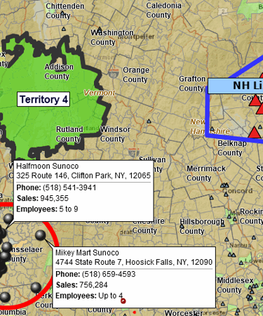
Label your business data using flexible callouts

Show more than one callout on map at a time. Add notes to individual map callouts. Change callouts orientation for better map layouts. Customize callouts look & feel.
Search business data in full-featured tabular view

Search your data records by business name. Sort data view by any variable. Filter data by custom criteria. View search results on map.
Select from a list of map templates

Includes Street view, State boundary, County boundary, and ZIP code boundary maps. Maps access the latest and most accurate street and base maps of North America. Mix map templates with flexible map settings and transparency.
Create state or regional map views

Filter map view to show only selected states or regions. Create local maps that display only certain counties or ZIP codes from your market area or within a radius.
Add a variety of layers and data to map

Includes ZIP codes, Counties, States, Metropolitan Statistical Areas (MSA), Census Tracts, City Limits, ZIP3 codes, US cities, Highways, and other map layers.
Generate demographic reports

Aggregate demographic data by radius, polygon, or drive time. Get insights into your existing markets or explore potential markets. Add territory demographic profile to a map or export it into a file.
Select satellite imagery map background

Use satellite imagery map background for the additional valuable context in your visual map analysis – refer to building footprints, land-use features, bridges and road layouts in proximity to your area-of-interest.
Create maps for various map regions

Make maps for US and Canada. Design sales territories and export demographic data for all regions supported. Streets and aerial maps are available for entire World.
MapBusinessOnline SDK
The SDK is a set of map developer tools. With SDK and certain programming skills you can integrate corporate CRM or accounting systems with MBO.
Learn How Our Customers are Succeeding with MapBusinessOnline

"MapBusinessOnline has played a major role in helping us to expand. It has helped us successfully map out our territories so that we know where we are and where we can be. With a clear picture of where we are, it has helped make it easier to locate available territory for our new Franchisees. MapBusinessOnline has even helped us keep our guarantee and carry out its promise for a five mile protection radius for each Franchisee. MapBusinessOnline has not only given us a map of where we are now, but it has also given us a map for our future."
Sine Schirmer
Franchise Support Department Head
The Tutoring Center Franchise Corp

"MapBusinessOnline has helped my organization visualize our territories in very little time. I created maps that allowed us to see where we are doing well and where we may be struggling. Getting this information has helped us capitalize on our opportunities and build our brand throughout the country."
Elwin Warsh
Strategic Sales Analyst
The Honest Kitchen

"In a large company, with many layers of sales teams, sales management, territories, operations teams and distribution, it is vital to have a solution to quickly and easily display country and regional maps. I have tried multiple other mapping solutions in the past only to be frustrated by their limitations or by their complexity. MapBusinessOnline perfectly fits my need. MBO has the versatility to allow me to build somewhat complicated maps but also allows me to knock out the quick, one-off request. MBO continues to add features and I am excited to see what new features come out next."
Dave Perek
Sr Business Analyst
Schneider Electric