MapBusinessOnline – Your Badger Alternative

Territory mapping has many potential benefits. As more businesses realize the importance of mapping business data in a geographic format, the software industry has filled with programs that claim to deliver insights about customers and sales.
The right territory mapping software for you will depend on several different factors. Recently, Badger has emerged as a popular sales planning platform. Let's take a look at how it stacks up against MapBusinessOnline.
Functionality
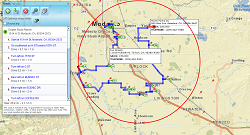
Badger designed its namesake software primarily as a sales mapping tool. It includes useful features for mapping out leads, tracking individual performance, optimizing routes and more. With Badger, you can import CRM data and plot it visually on a map of your sales territories, identifying leads and opportunities in the process.
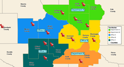
MapBusinessOnline offers all of the above functionality, plus additional features that add significant strategic value to a basic sales planning tool like Badger. With MapBusinessOnline, you have more flexibility to create custom maps and sales territories based on your particular business criteria. It also allows you to access insights about the overall state of your business, making it more effective at big-picture, strategic planning. For example, MapBusinessOnline includes tools that can assist with site selection for a new location, as well as the ability to create heat maps and other advanced data visualizations.
If you need a mapping software that focuses exclusively on sales support, the simpler Badger may be the choice for you. However, if you want to do more with your data, MapBusinessOnline is ultimately a more flexible platform.
Demographic Data
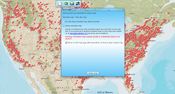
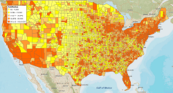
One unique feature of MapBusinessOnline not available in Badger — and one of the reasons why MBO is one of the best mapping software platforms for businesses — is its seamless incorporation of current Census demographic data. MapBusinessOnline makes it easy to access information about who your customers are, where they live and how they shop. Your subscription includes full access to information from U.S., UK or Canadian census records, and it allows you to drill down to specific ZIP/postal codes and learn more about factors such as population, age, average household income and more. Demographic projection datasets are included too.
Pricing and Support
MapBusinessOnline offers multiple subscription options — Standard, Pro and Team plans. MapBusinessOnline offers flexible large user enterprise plans that accommodate various business models. Badger's price structure offers individual, business and enterprise plans.
Pricing for the full featured MapBusinessOnline starts at $500.00 per year for a single user. Badger offers a slimmed down version of its individual user package for $9/month or about $108 per year. All Map Business Online customers receive access to world-class, one-on-one technical support.
Both Badger and MapBusinessOnline offer no-obligation free trials. Try out both, and you'll agree that MapBusinessOnline is not just the better value, but it’s also the best business mapping software platform available today.
See MapBusinessOnline in Action
Request a demo
- Plot data from Microsoft® Excel
- Optimize stops order in route
- Manually create territories one-by-one
- More...
Learn How Our Customers are Succeeding with MapBusinessOnline
The Alternative Board (TED), an advisory board creation service for business of all types and sizes, used MapPoint to import customer locations, create and manage territories, and for visual market analysis. When MapPoint left them high and dry, they began looking for a MapPoint replacement. This process led them to MapBusinessOnline.
Over a period of a few weeks MapBusinessOnline shared several online web demo that showed exactly how MapBusinessOnline would replace and improve upon the mapping technology TED had become used to. The Alternative Board recently renewed their Map Business Online subscription for another year.
The Alternative Board

"I just wanted to say thank you for this amazing mapping tool! I've tried a number of sales territory map solutions and this is by far the best. I just (finally!) switched over from MapPoint and this is so much better, I wish I had switched sooner. Your videos and blog are also really helpful, though most things I have figured out on my own. It looks like I also have a lot more to discover as I explore the data visualization tools. Thanks again!"
Andrea Harrison
Business Analyst
Brainlab, Inc.
"I have been using MapBusinessOnline for about 8 months and couldn’t be happier with the services it provides. I have employees and myself who map around 250 routes monthly for our sales team. The interface is easy-to-use and the abilities are exactly what I need. My sales team finds the maps and step by step routes easy to follow and accurate. My store lists change every quarter and the uploading system allows me to quickly upload a new list and categorize the account by priority using colors and shapes. I have also used the heat mapping capabilities and found those easy to customize and quick to use. As with any advanced software, this does take a week or two to learn the more complex features, but it is well worth the time invested. This is the software I would have designed if I was to create one myself. Great job!!!"
Bill Hanavan
Director of Operations
Strategic Retail Solutions

Popular MapBusinessOnline features
Build fast map visualizations of your business data
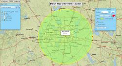
Design and visualize sales territories
Plan customers visits with optimized routing
Display business data against demographic maps
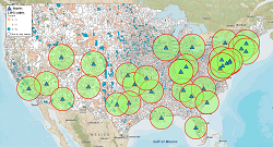
Perform Market Analysis for multiple sites
Draw custom graphics and annotate maps
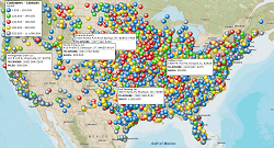
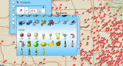
Visualize business data on map with various symbols
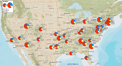
Illustrate business data on map with charts
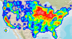
Emphasize customers density with heat maps
Print large format map views
Share business maps