Creating Interactive Maps

MapBusinessOnline gives users the ability to create interactive maps that let you manipulate data in near real-time. Interactive maps are a powerful presentation tool and a great way to test out different scenarios when working through an idea. Whether you're making a pitch to upper management or mapping out new sales territories, our interactive features create an advanced platform for viewing and manipulating data in a geographic context.
How It Works
The key to MapBusinessOnline's ability to create interactive maps is its seamless integration with your existing data. MapBusinessOnline integrates directly with with SalesForce, while offering an easy export/import interoperability with QuickBooks, Excel and other common enterprise platforms, easily importing up-to-date datasets containing sales records and other business intelligence. Users can then plot this information on a map, draw up custom territories to compare one region to another, or even access demographic information from official census and third-party sources.
MapBusinessOnline includes several features and functionalities that help you create customized interactive maps. With it, you can:
- Highlight data and geographic elements with a range of map visualization and symbolization options
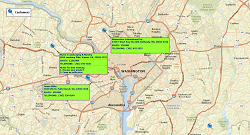
- Design custom labels and callouts that provide context to the data presented in your map
- Color-code your map by zip code, city, county or state to differentiate between distinct regions and business units
- Export maps into presentation-ready image file or PDF formats
- Use the application itself to present
- Share and collaborate remotely while maintaining data and file integrity
Benefits of Interactive Maps
Interactive mapping software is more than just a presentation tool. While the ability to create attractive, eye-catching custom maps can be incredibly useful when advocating for new ideas or initiatives, it's also essential for strategy development and testing out different scenarios, as your visualization workshop adjusts and fine tunes their marketing, sales or planning. Interactive maps help with:
- Sales territory management: Using an interactive map, you can see which areas are meeting their benchmarks and which are underperforming, and assign resources appropriately.
- Market analysis: With an interactive map, you can drill down on demographic information in a specific area, filtering out unwanted factors to develop more targeted advertising and sales plans.
- Site selection: An interactive map lets you test out potential sites for a new location or business expansion, and look at factors such as area demographics, real estate pricing, competition location and more.
- Route planning: MapBusinessOnline's interactive mapping software is ideal for route planning. With it, you can see where your customers or clients are and while securing the most efficient way to get from point A to point B.
Explore our website to learn more about our software's interactive mapping capabilities. Want to see MapBusinessOnline in action? A free 1-month trial is available. Download yours today or contact us to arrange a demonstration at your convenience.
Learn How Our Customers are Succeeding with MapBusinessOnline

"MapBusinessOnline helps me identify our most promising markets and define exactly those contacts I’m going to market to. It's the best product I've found that lets me 'visualize' my data."
Tom Jans
Director of Marketing
Swing Surgeon Golf Management
"In a large company, with many layers of sales teams, sales management, territories, operations teams and distribution, it is vital to have a solution to quickly and easily display country and regional maps. I have tried multiple other mapping solutions in the past only to be frustrated by their limitations or by their complexity. MapBusinessOnline perfectly fits my need. MBO has the versatility to allow me to build somewhat complicated maps but also allows me to knock out the quick, one-off request. MBO continues to add features and I am excited to see what new features come out next."
Dave Perek
Sr Business Analyst
Schneider Electric

"MapBusinessOnline has made it easy for DriSteem to locate and compare Rep territories. Every single person in our office has a map from MapBusinessOnline at their desk and refers to it daily. We are thankful to be using MapBusinessOnline for developing our business and outside sales representative team!
Thank you MapBusinessOnline!"
Abby Rogers
Marketing Coordinator
DriSteem Corporation

Popular MapBusinessOnline features
Quickly build map visualizations of your business data
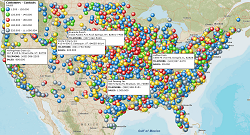
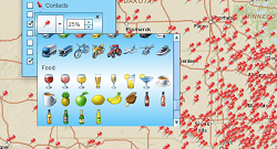
Visualize business data maps using data symbols
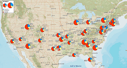
Illustrate business data maps with charts
Label your business data using flexible callouts
Draw custom graphics on the map
Share business maps
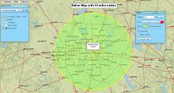
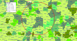
Search data spatially with radius maps
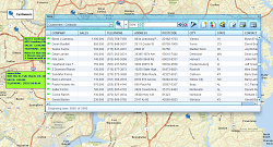
Search business data in full-featured tabular view