Sales Planning with Web Maps Sales Preparation
“Sales is 75% luck and 25% preparation for when luck hits.” – A lifelong successful sales executive
Sales projections are subject to change. Sales deliverables are at the mercy of unpredictable factors including the economy, the competitive environment, and the buyer’s whim. But there are elements impacting sales that are traceable and predictable, and one of those elements is geography. The location of sales activities, sales territories, and customer areas of operation are knowable. These location points related to selling can be visualized, analyzed and exploited using business web maps. They should be part of a successful sales person’s 25% preparation.
Business mapping tools are now common supplements to CRM and sales management software tools. These typically cloud based software services are extremely affordable and have minimal impact on a busy IT department. These map tools convert imported customer and prospect address lists or spreadsheets into patterns and possibilities – the basis for a plan.
Import Your Business Data
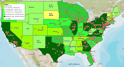
First and foremost Web Maps can help visualize a sales plan. Projected sales numbers can be displayed geographically to reflect sales by region or section. When displayed against population data or pertinent product sales information, these map visualizations can clearly show were greater effort might lead to desired results. Thus map visualizations can inform sales planners of potential markets and suggest activities that might be implemented to drive sales.
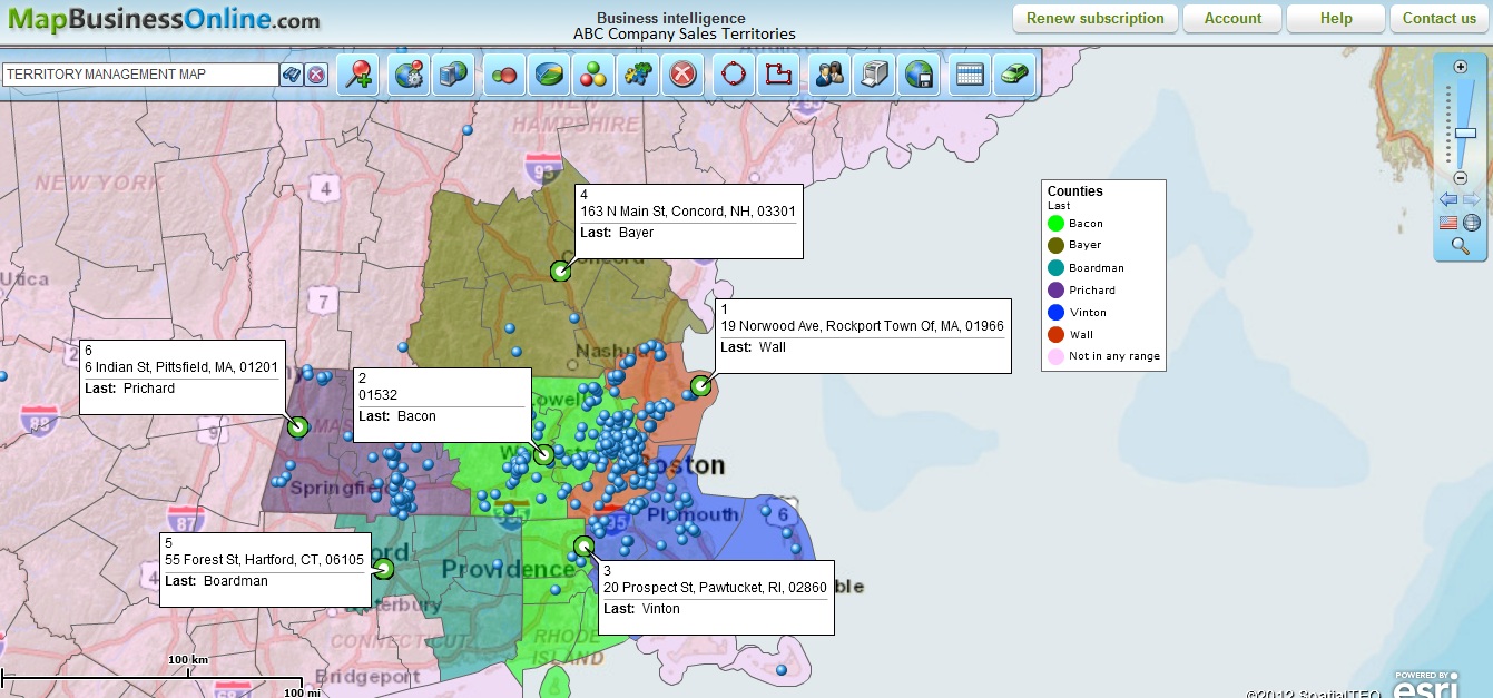
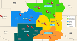
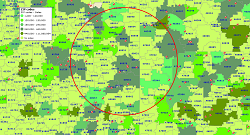
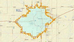
To make sure sales activities take place in a timely fashion, sales territory accountability can be assigned using web maps. Nothing outlines accountability for sales better than a color-coded area on a web map. Whether the plan calls for state, county or zip-code level activity, common web mapping tools will display sales zones with absolute clarity making sure inside and outside sales people know where their activities will be focused and who is held accountable.
Sales Plans typically include budgets for travel and conferences, scheduled out over a period of time. Web business maps can help define and control both travel and sales activities, like conferences or sales trips, by enabling efficient planning tools.
Sales Planning With Maps
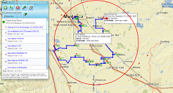
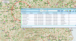
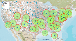
Developing a conference schedule covering a six to twelve month period provides a rough estimate of projected sales travel for an entire year. By using web maps to plan visits sales people can maximize exposure to customers while controlling costs. Web maps let users import both customers and prospects on to a map background for easy visualization of exact locations. Radius searches enable segmentation of customers within a defined radius. Users can save and export subset lists to 3rd party marketing or CRM applications for prospect notifications; let them know you’ll be in town or invite them to your conference booth. Based on marketing results, a sales person may decide to stay a few extra days, rent a car, and go visit those key contacts that missed the conference. Be sure to route efficiently to keep fuel costs in line with travel budget projections.
Few things help controls sale’s costs better than efficient sales trips. Smart sales people use web maps to display prospects and customer on a map. Choose the customers you will visit based on their proximity to your point of departure - hotel, airport or home. Often multi-stop routing tools can be applied to improve efficiencies and provide the optimum routes based on all factors – schedules, distances, road speeds, and even turn restrictions.
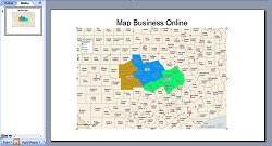
Typically web map views can be saved in standard file formats, like JPEG, PNG or PDF for sharing. Illustrations always liven up a PowerPoint presentation, and colorful maps will inform your audience of the critical elements supporting major presentation messages. Display cost savings for the CFO showing travel cost reductions using maps or, more importantly, show sales increases in the areas assigned at the beginning of the year. Nothing plays better than increased sales numbers and associating them with a colorful map image can make a business map user look like the next sales director. Luck indeed!
Affordable Business Maps to for Sales Planning, right now.
Register online for 1-month FREE trial today!
Learn How Our Customers are Succeeding with MapBusinessOnline

"You guys are awesome! I used the MapBusinessOnline trial to get promoted to a sales position within my company. I showed them how I would work my territory with great MBO printed maps that showed projected sales dollars by account locations. I got the Job!"
Jeff Krieger
Territory Manager
Mizuno USA
DPS is the leading provider of timely, relevant and motivational promotional materials for automotive dealerships. Their business strategies drive customer loyalty and sales revenues. Their sales manager uses MBO to create and manage sales territories and describes MBO this way,
"The product is phenomenal and the support even better."
Dealer Product Services (DPS)

"I wanted to thank my customer service rep Jason for always going above and beyond every time I call for answers...AND THIS IS WHILE I AM USING A TRIAL VERSION!!! With this kind of service, why would you ever use another software company?"
David imports his USA-wide network of restaurant service suppliers and uses the map to visualize his contacts for instant access.
"Every time I use MapBusinessOnline…and I always get what I need."
David Ziviello
Sales
RositoBisani

Popular MapBusinessOnline features
Build fast map visualizations of your business data
Design and visualize sales territories
Plan customers visits with optimized routing
Use maps to create marketing campaigns
Search data spatially with radius maps
Add drive time polygons to your market analysis tools
Perform Market Analysis for multiple sites
Visualize business data on map with various symbols
Color code maps by ZIP code, county, or state
Create powerful reports and presentations with maps
Share business maps