Import ZIP Code Territories from CRM
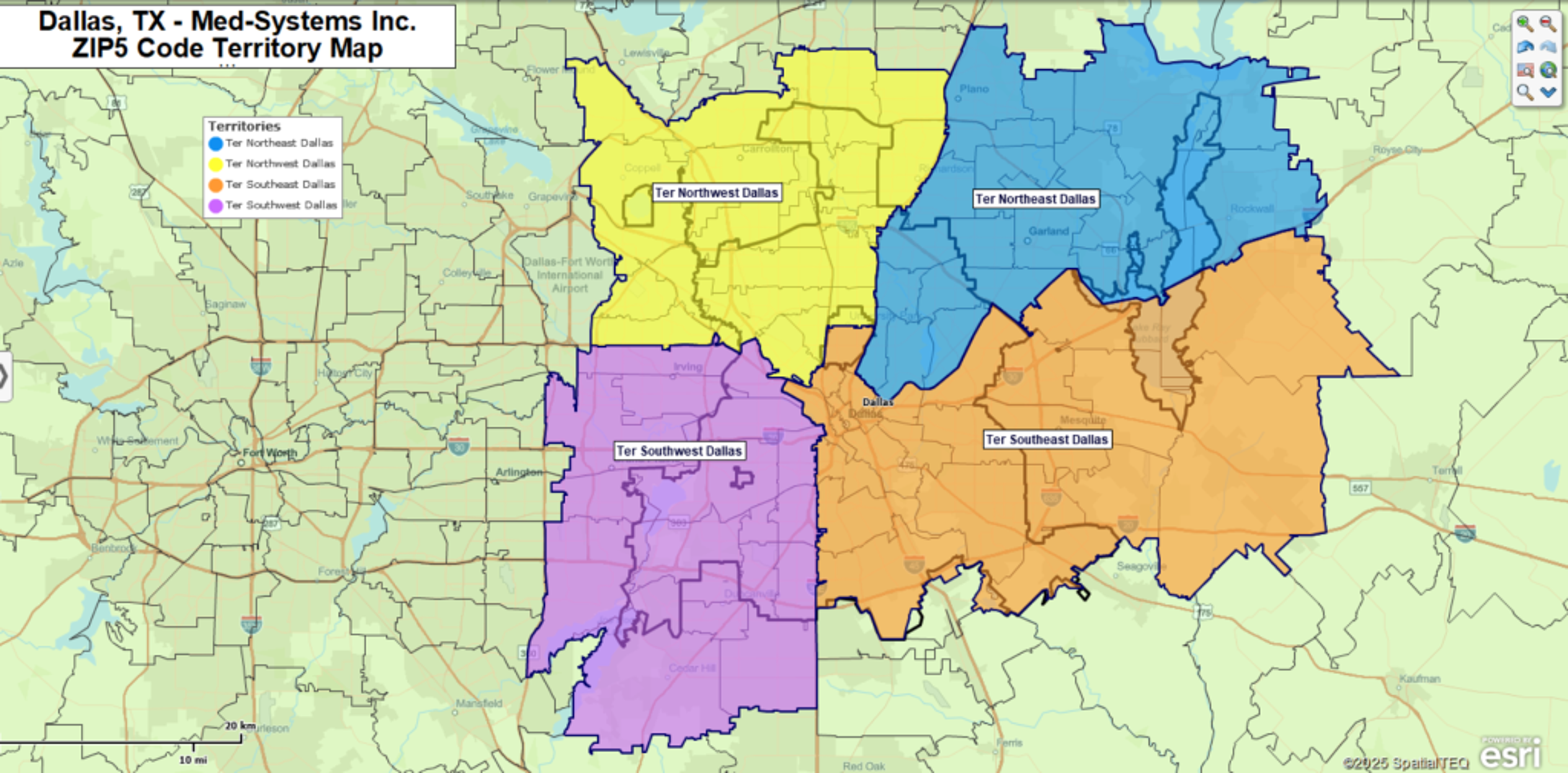
Customer Relationship Management, or CRM, systems are used to help sales organizations organize and manage interactions with customers and prospects. Most CRM's will allow their customers to define territory assignments by ZIP code. These lists of ZIP code assignments can be exported to business mapping software to generate territory maps that visually define:
- Areas accountability for sales representatives
- Sales goals by geographic areas
- Sales planning maps to improve productivity and drive down expenses
But ZIP codes can be tricky, especially for CRM systems that are not spatially enabled, which can lead to misapplied territory assignments by ZIP codes. As it turns out, not all ZIP codes are the same. This paper will help CRM users more easily navigate what can be a confusing disconnect between CRM systems and sales territory mapping software.
Boundary and Point ZIP Codes
Most business people do not realize that ZIP codes come in several types, namely ZIP codes with boundaries and point ZIP codes. Most of us are used to the concept of a boundary ZIP code because we grew up in a boundary ZIP code area. There are currently 33,461 boundary ZIP codes mapped across the USA by the United States Postal Service.
But there are another 7,563 ZIP codes that are Point ZIP codes. These are ZIP codes that represent single facilities on a map. These point ZIP codes represent military installations, hospitals, museums, large companies, or massive apartment buildings. For these ZIP codes, geography is no more than a point on a map.
CRM applications generally treat all ZIP codes the same. CRM doesn't have to worry about ZIP codes with spatial boundaries because they are not mapping applications. Thus, a territory made up of ZIP codes in a CRM system has a little less than a 23% chance of including point ZIP codes. Point ZIP code use happens and it happens often.
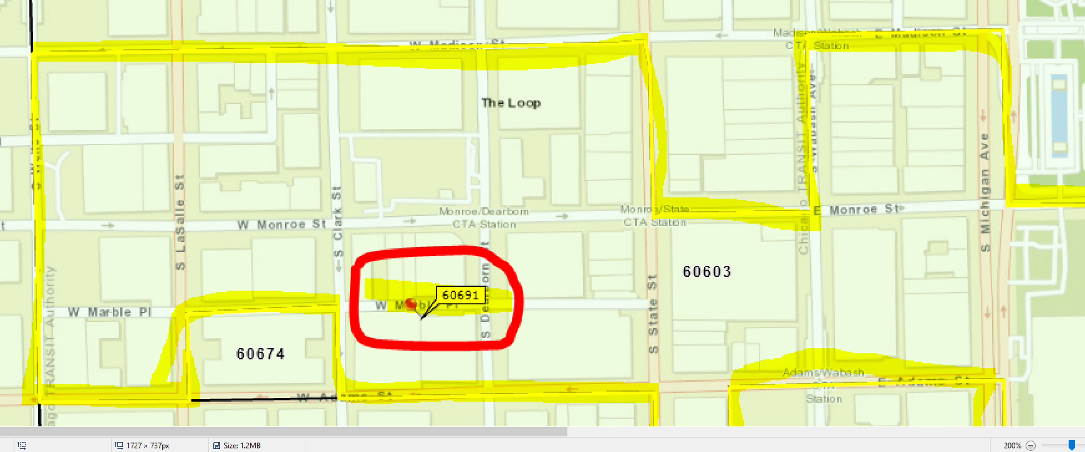
Figure 1 – A Point ZIP code 60691 within Boundary ZIP code 60603
The MapBusinessOnline ZIP Code Solution
When importing location-based data into MapBusinessOnline all ZIP codes, boundary or point, will plot accurately. But you will notice that point ZIP codes plot as a point which will typically display inside of a boundary ZIP code when viewed on the map. See Figure 1 above.
Datasets imported to automatically create Territories in MBO will only plot boundary ZIP codes. That's because, in a mapping application, territory assignment generally implies the use of geographic boundaries. In general, most territories are based on ZIP code boundaries as opposed to other map layers such as counties or states.
To avoid automatically assigning point ZIP codes as territory boundary components, MapBusinessOnline includes an option to "Ignore point-only (no-boundary) ZIP codes" during territory creation. You'll find this option in the geo-coding assignment dialogue of the territory import process.
It is advisable to leave the Ignore Point-only ZIP Codes box checked on to avoid the misapplication of geographic territories to point ZIP code candidates.
Failure to filter out point ZIP codes from a territory by ZIP code data import can lead to confusing and wrong territory assignments as point ZIP codes get applied to the wrong territory.
MapBusinessOnline provides a complete dataset of all ZIP codes by point for querying all ZIP codes by territory. This assures sales territory mapping users can query and export lists of all ZIP codes assigned to a given territory.
The Advantages of Geographic vs. CRM Territory ZIP Code Assignments
Create Adjoining Territories - Assigning territories by ZIP codes, taking advantage of their geographic boundaries, offers distinct advantages over simple spreadsheet ZIP assignments and CRM lists using ZIP codes of any type. Geographic based territory assignments clearly define areas of accountability which are easily visualized on a digital map. The sales representative sees their territory and understands their responsibility.
Simply assigning a list of general ZIP codes, that may include both point and boundary ZIP codes, leaves the areas of accountability open-ended. Assigned point ZIP codes may fall outside the boundary ZIP code areas. Some of those point ZIPs, assigned to one representative, will inevitably fall into another representative's ZIP code territory. And this will create conflict within the sales team.
- Disputed or unclear geographic territory boundaries create confusion about account responsibility
- Overlapping territory assignments drive up travel expenses
- Overlapping territory assignments make calculations of sales results more difficult and subject to error
CRM territories created from ZIP codes in business mapping software tend to be incrementally assigned. Any group of ZIP codes assigned to a territory will tend to expose numerous unassigned ZIP codes in areas surrounding the selection. Geographic territory mapping tools enable fast groupings of all ZIP codes in a given area for easy aggregation into territory assignments.
MapBusinessOnline includes settings that address the identification of overlapping territory segments, providing controls over overlap identification.
Geographic territory assignment using lassoing or polygon selection is much more effective at creating adjoining territories than filtering by ranges, which will inevitably expose holes or unfilled ZIPs, in ZIP code-based territories.
Balancing Territories – Geographic territory mapping tools, like MapBusinessOnline, provide various ways to balance territories, assuring equity in sales assignments, account responsibility, and workloads.
Business mapping software includes tools for radius search or circle creation that can serve as a guide for territory assignment. For instance, all territories are based on ZIP codes within twenty-five miles of a sales representative's home base. Likewise, drive time assessments can also be used to determine the grouping of contiguous ZIP codes keeping territories relatively balanced by focusing on driving distances in all directions from each sales rep's home base. Such drive time-based assignment can assure no sales rep drives more than one hour to a client's place of business.
Another way to view territory balancing is through demographic analysis. Business mapping tools include access to a variety of Census demographic data enabling the quick and easy analysis of territories by population density, median income distribution, or a host of other categories. Each assigned territory can be governed by the volume of its demographic make-up. For example, all sales territory assignments might demographically include roughly 50,000 Hispanic Americans.
To avoid sales management pitfalls like unfilled territory ZIP codes or misbalanced territories. Simply rely on a business mapping software to create territory assignments based on geographic boundaries that are easily visualized and shared across your sales team. Keep your sales team accountable, balanced, and focused on selling.


