MapBusinessOnline – Advanced Alternative to BatchGeo
Upgrade to Advanced Business Mapping
MapBusinessOnline competes with several geospatial software companies, including BatchGeo, which offers mapping services based on Google Maps. MapBusinessOnline, a cloud-based business mapping service, is the perfect, affordable alternative to BatchGeo or other web-based mapping solutions that aren’t quite right for your business. These solutions may work well for basic map visualizations of several hundred to several thousand locations. Still, when it comes to territory design or more advanced market analysis tools, often required to make better business decisions, MapBusinessOnline is the most advanced tool in its class.
You’ll find that MapBusinessOnline provides a complete set of business mapping features that may just be less expensive than some of our major competitors. Additionally, our geocoding services are vast, fast, and affordable.
MapBusinessOnline Provides a Complete Set of Business Mapping Features
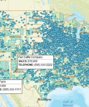
- Import and display up to 250,000 records in just a few minutes – fast & furious!
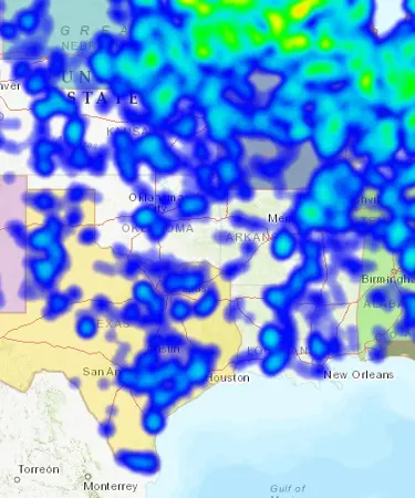
- Color-code and symbolize your business data – including heat maps!
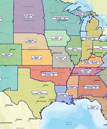
- Create and manage sales territories that drive accountability into your processes. Create territories defined by state, county, ZIP code, and other geographies.
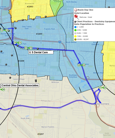
- Improve sales and delivery productivity with optimized route planning.
- Build demographic maps supporting your business expansion plans.
- Use the most recent and accurate map data available!
- Conduct drive time analysis – search areas and business data by drive-time polygons.
- Print large format maps – up to 5’ by 5’!
- Import map presentation graphics into PowerPoint presentations.
- Easily share sales results by territory or state.
- Compare multiple datasets using our Market Analysis tools.
- Access 5 & 3-digit ZIP codes, Census tracts, counties, states, city limits, & MSAs.
- Color-code your data by ZIP, county, city, or state.
- Set up shared map editing teams – leverage your best minds!
- Access your cloud-based maps from anywhere – just connect to the Internet!
- Supports address geocoding in the US and Canada.
- Exchange data with your CRM or QuickBooks.
- Unsurpassed technical support to help the greenest of users.
Still considering the switch from BatchGeo to MapBusinessOnline? Take a free trial to try MapBusinessOnline first!
See MapBusinessOnline in Action
Request a demo
Learn How Our Customers are Succeeding with MapBusinessOnline

"I have been using MapBusinessOnline for about 8 months and couldn’t be happier with the services it provides. I have employees and myself who map around 250 routes monthly for our sales team. The interface is easy-to-use and the abilities are exactly what I need. My sales team finds the maps and step by step routes easy to follow and accurate. My store lists change every quarter and the uploading system allows me to quickly upload a new list and categorize the account by priority using colors and shapes. I have also used the heat mapping capabilities and found those easy to customize and quick to use. As with any advanced software, this does take a week or two to learn the more complex features, but it is well worth the time invested. This is the software I would have designed if I was to create one myself. Great job!!!"
Bill Hanavan
Director of Operations
Strategic Retail Solutions

"I use it daily to visualize customers and sales territories, and to plan sales trips. It’s so intuitive."
Jeanne Gazlay
Life Brokerage sales Director
Mutual of Omaha

"I have had the pleasure of using MapBusinessOnline for the past 5 years and it is an excellent and affordable tool for my clients. I am a franchise consultant, and many of my clients are just starting to get into franchising. The first main question many of them have is they don’t know the demographics around their current location, so they don’t know how to create territories for their franchisees. I am able to easily utilize MapBusinessOnline to draw a prototype territory around their existing location, do a deep dive into the many different demographics that MapBusinessOnline offers, and help the client determine the basics of their new territories, including mileage, population, household count, purchasing habits and age distributions. This tool has been so helpful that many of our clients obtain their own accounts as they begin to sell franchises and grow their business. Thank you, MapBusinessOnline, for providing such a helpful tool that is affordable and easy to use!"
Colette Bell
Director of Business Development
SMB Franchise Advisors
Popular MapBusinessOnline features
Build fast map visualizations of your business data

Map business data from various sources by street address, city name, ZIP code, or latitude and longitude. Plot 250,000 or more locations on a map at once. All you need to start is a spreadsheet with business data.
Design and visualize sales territories

Use our sales territory mapping software to create sales territories by ZIP code, county, or state. Aggregate demographics and sales data by territory. Search business data inside sales territories. Highlight territory overlap.
Plan customers visits with optimized routing

Use maps to identify customers within a radius or polygon. Optimize visits sequence and generate turn-by-turn driving directions. Reduce travel costs. Improve ROI and productivity.
Display business data against demographic maps

Categorize geographic areas by population or household income. Explore new markets, business patterns, or social trends against color coded Census maps for business and competitor analysis.
Perform market analysis for multiple sites

Search & segment data from multiple centers. Generate market area profiles. Find nearest store or pick up locations. Batch calculate distances, as well as driving times to multiple locations. Aggregate demographic data. Enrich a dataset with demographic or geographic variables.
Draw custom graphics and annotate maps

Draw circles, rectangles, polygons, and lines. Choose from a selection of line styles and fill colors. Identify map locations with text. Draw market areas and sales territories. Customize your business map.
Visualize business data on map with various symbols

Assign specific symbols, colors, and sizes to your data points on map. Choose from a wide variety of symbols or create your own. Visually define customers and prospects across multiple locations using symbols color coding.
Illustrate business data on map with charts

Graphically depict your business data on a map using pie or bar charts. Use charts to show sales by product, invoices due vs. paid, products ordered vs. shipped, and sales by customer demographics.
Emphasize customers density with heat maps

Highlight market areas that generate more business. Visually compare map areas for business potential. Select from a variety of heat map colors and options.
Print large format map views

Print large maps to use in presentations and project plans. Save maps as PDF files to print as large as 60” x 60” customer maps. Supports multiple pages option to use your home or office printer for large wall maps.
Share business maps

Create interactive maps and share with friends, colleagues, dealers, customers, prospects or vendors. Share territory maps. Email saved JPEG and PNG files or embed map files in PowerPoint presentations. Includes PDF export for larger print formats.


