Interactive Mapping Software
to Start Creating Interactive Business Web Maps – Take a FREE Trial
While old-fashioned wall maps can be effective business planning tools, they are not known for their flexibility. And a typical desktop mapping software is designed for one user at a time. When you create an interactive web map with user-friendly software from MapBusinessOnline, you get the benefit of up-to-date mapping data that can be easily manipulated and shared among your critical business associates and teams. Interactive web maps drive efficient business communication.
Easily Import Your Business Data
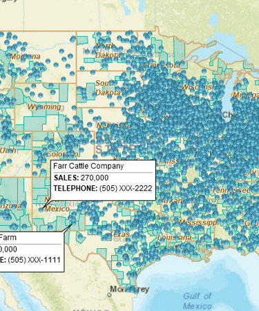
The beauty of creating interactive maps is that you can quickly import real-time business data from your Excel spreadsheets and immediately realize and share the benefit of geographic visualizations. You’ll have the flexibility to map business data from multiple sources by street address, city name, or longitude and latitude. You can also create an interactive local ZIP code map or an interactive US map, depending on your area of interest. MapBusinessOnline offers the capability to plot as many as 250,000 locations at one time. Valuable business data that can be accessed by your associates via interactive maps includes:
- Geographic location of prospects and competitors throughout a sales territory or region
- Location of current customer base for more efficient sales territory development
- Significant demographic trends such as population or income increases, or decreases within a target area
- Ability to pinpoint and display your business’s critical resource locations
- Opportunity to display and segment business revenue by categories such as product, customer type, products ordered vs. products shipped, etc.
Interactive Maps Offer Many Important Business Benefits
Using MapBusinessOnline software to create an interactive Web map allows you to quickly identify and react to trends and possible risks that can have an immediate impact on your business. For instance, if you’re a sales manager, you can use our mapping tool to analyze whether a competitor is posing a challenge within a given territory and determine if a redeployment of resources is necessary to eliminate the threat. You can also increase the efficiency of your salespeople by optimizing multi-stop route planning, enabling them to visit more prospects and customers while driving down fuel costs.
By making interactive maps a part of your business planning function, you can:
- Improve customer service response rates
- Increase sales revenues and productivity within a given territory
- Identify where competitors are taking market share
- Make the most out of limited sales and marketing resources
- Increase profitability by improving efficiencies and reducing operating costs
Create an Interactive Map You Can Share with Other Members of Your Team
Unlike wall maps, our web-based interactive maps can be easily shared with colleagues in another territory or state, or even across the country. This makes our software a valuable tool for use in collaborative decision-making environments. Map files can also be embedded in PowerPoint presentations to add powerful visual impacts to strategic sales plans. The PDF export feature also allows you to print full-color, large format maps if preferred.
We’re America’s Fastest-Growing Business Mapping Software Solution
MapBusinessOnline is a leader in the development of interactive business mapping software, and we continue to experience rapid growth today as we expand the products functionality based on customer requests. Our customers know they can count on us to deliver cost-effective software featuring data compiled by the world’s foremost GIS experts. We back our products with world-class technical support every step of the way. Other key MapBusinessOnline benefits include:
- Outstanding USA mapping software solutions since 1996
- The best sales territory management tools in its class
- Most user-friendly interface of any mapping software product
- Lowest price of any comparable mapping software solution
- Ability to create customized maps by incorporating multiple feature requests
- Personalized one-on-one technical support provided by well-trained professionals
- No-obligation FREE trial
Get Started With a Risk-FREE Trial
Discover how easy it can be to create an interactive map by taking advantage of our FREE trial. It’s the perfect way to experience the many benefits our mapping software can provide to your business!
Learn How Our Customers are Succeeding with MapBusinessOnline
"We use MBO for event planning at cities all across the USA. It’s easy and fast. It blows away the other applications we tried."
Kristine Gates
Strategic Accounts Sales Manager
Extend Health

"MapBusinessOnline has played a major role in helping us to expand. It has helped us successfully map out our territories so that we know where we are and where we can be. With a clear picture of where we are, it has helped make it easier to locate available territory for our new Franchisees. MapBusinessOnline has even helped us keep our guarantee and carry out its promise for a five mile protection radius for each Franchisee. MapBusinessOnline has not only given us a map of where we are now, but it has also given us a map for our future."
Sine Schirmer
Franchise Support Department Head
The Tutoring Center Franchise Corp
The Alternative Board (TED), an advisory board creation service for business of all types and sizes, used MapPoint to import customer locations, create and manage territories, and for visual market analysis. When MapPoint left them high and dry, they began looking for a MapPoint replacement. This process led them to MapBusinessOnline.
Over a period of a few weeks MapBusinessOnline shared several online web demo that showed exactly how MapBusinessOnline would replace and improve upon the mapping technology TED had become used to. The Alternative Board recently renewed their Map Business Online subscription for another year.
The Alternative Board

Popular MapBusinessOnline features
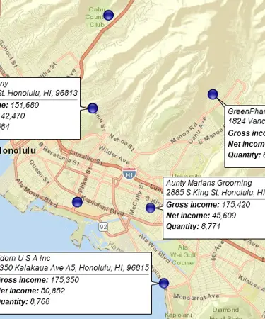
Build fast map visualizations of your business data

Map business data from various sources by street address, city name, ZIP code, or latitude and longitude. Plot 250,000 or more locations on a map at once. All you need to start is a spreadsheet with business data.
Draw custom graphics and annotate maps

Draw circles, rectangles, polygons, and lines. Choose from a selection of line styles and fill colors. Identify map locations with text. Draw market areas and sales territories. Customize your business map.
Print large format map views

Print large maps to use in presentations and project plans. Save maps as PDF files to print as large as 60” x 60” customer maps. Supports multiple pages option to use your home or office printer for large wall maps.
Share business maps

Create interactive maps and share with friends, colleagues, dealers, customers, prospects or vendors. Share territory maps. Email saved JPEG and PNG files or embed map files in PowerPoint presentations. Includes PDF export for larger print formats.
Visualize business data on map with various symbols

Assign specific symbols, colors, and sizes to your data points on map. Choose from a wide variety of symbols or create your own. Visually define customers and prospects across multiple locations using symbols color coding.
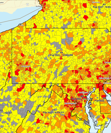
Color code maps by ZIP code, county, or state

Import business data by ZIP code to show it geographically. Create colorful maps for business analysis that connect real Census data to locations on the ground.
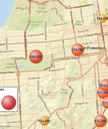
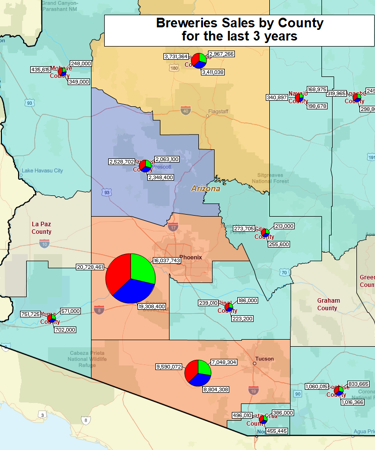
Illustrate business data on map with charts

Graphically depict your business data on a map using pie or bar charts. Use charts to show sales by product, invoices due vs. paid, products ordered vs. shipped, and sales by customer demographics.
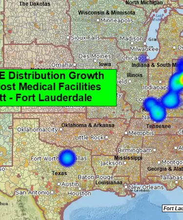
Emphasize customers density with heat maps

Highlight market areas that generate more business. Visually compare map areas for business potential. Select from a variety of heat map colors and options.
Display business data against demographic maps

Categorize geographic areas by population or household income. Explore new markets, business patterns, or social trends against color coded Census maps for business and competitor analysis.
Create state or regional map views

Filter map view to show only selected states or regions. Create local maps that display only certain counties or ZIP codes from your market area or within a radius.
Create powerful reports and presentations with maps

Embed map images into reports. Use interactive maps for effective presentations. Export map as PDF to create large wall maps.


