Create a Service Area Map
By ZIP Code

Import a ZIP list or select ZIPs on the map. You can also build areas by ZIP3, cities, counties, and states.
By Radius

Create single or multiple radii (e.g., 5/10/15 miles) around one or many locations.
By Drive Time

Create drive-time areas from one or multiple locations based on traffic by time and day.
What You Can Do with a Service Area Map
After building a service area — by ZIP Code, radius, or drive time — you can start using it for strategic planning and day-to-day operations:
-
Analyze markets and opportunities: Combine service areas with demographics or sales data to find growth regions, coverage gaps, and new site opportunities.
-
Identify customers and assets: See which customers, stores, or assets fall inside the service area to understand who you serve and where to expand.
-
Manage sales territories: Define territories by ZIPs, counties, or states, align with CRMs for lead routing and performance tracking, and rebalance as your team or market changes.
-
Verify coverage: Check whether a customer address or ZIP Code is inside your service area to confirm eligibility or route orders accurately.
-
Optimize delivery and logistics zones: Plan delivery areas, fees, and service levels; balance driver workloads; and minimize travel time using realistic distance and drive-time zones.
-
Export ZIP Codes: Create accurate ZIP Code lists for delivery routing, territory planning, or CRM and marketing systems.
-
Share and collaborate: Publish an interactive map, export images or PDFs, or print large-format maps for team or executive communication.
-
Prospect inside your area: Use Business Listings to find new customers or leads within your defined service areas.
How to Build a Service Area Map (Choose the Best Method)
By ZIP Codes & Admin Areas — When Precision Lists Matter
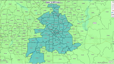
ZIP Codes and other administrative boundaries are the most common way to define a service area. With MapBusinessOnline, you can import a list of ZIP Codes or select them directly on the map. You can also build service areas by ZIP3, city, county, or state, ensuring that your map aligns perfectly with the areas you need to report on.
This method is ideal when you must publish eligibility lists, keep franchisees and operations aligned, or generate clean handoffs to CRM and logistics systems. You can summarize data inside your chosen areas, color-code for analysis, and export exactly which ZIPs, counties, or states are included.
By Radius — Fast Distance Answers
Radius mapping is the simplest way to show reach. You can draw single or multiple radii around one or many locations, setting distances like 5, 10, or 15 miles. This is the quickest way to communicate promises such as “we serve customers within 10 miles of our store” or to find which customers fall within 20 miles of a warehouse, clinic, or retail location.
Radius maps are perfect for store locator tools, local guarantees, and quick market analysis. They’re also ideal for conducting ring studies — comparing demographics, customer counts, or revenue potential within concentric distance bands around key sites. You can generate overlapping circles to visualize reach across multiple locations, and if you need accountability, convert those rings into formal territories.
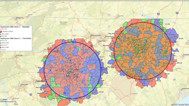
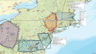
By Drive Time — Real-World Reach
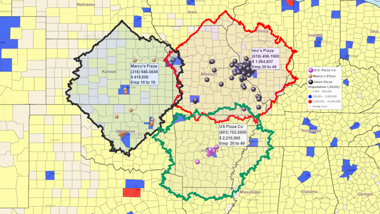
Drive-time analysis reflects how long it actually takes to reach a location, not just how far away it is. With MapBusinessOnline, you can build single or multiple drive-time areas, and add multiple time bands such as 10, 20, or 30 minutes. Unlike simple distance rings, drive-time areas factor in traffic conditions by time of day and day of week - helping you create service promises that hold up in the real world.
This method is ideal for urban delivery zones, appointment scheduling, and service-level agreements where time is more important than mileage. It helps you compare reach across multiple sites, identify overlaps or gaps, and balance service responsibilities between locations. You can also switch to drive distance if your business communicates in miles rather than minutes.
Hand-Drawn Areas — Irregular Footprints
Not every service area fits neatly into circles or ZIP Code lists. That’s where hand-drawn areas come in. You can sketch free-form polygons to capture irregular footprints shaped by rivers, highways, or private roads, or to highlight unique coverage zones such as telecom or utility service areas.
Hand-drawn areas are particularly useful for visual communication, proposals, and one-off exceptions that don’t need list precision. But if you do need a reportable list later, you can convert the same outline into ZIPs, counties, or other admin boundaries to ensure your map matches your data systems. This flexibility means you can start with a visual and end with a spreadsheet when business needs to evolve.
Service Area vs. Coverage Area
The terms “service area” and “coverage area” are often used interchangeably, but they’re not the same. A service area refers to the geography your business actively serves — like a retailer’s delivery zone or a field technician’s territory. A coverage area is often used in industries like telecom to show where a network signal or utility service is available.
MapBusinessOnline supports both concepts. You can use ZIPs, radius, or drive-time to define clear service areas, and hand-drawn areas to illustrate coverage footprints that don’t follow standard boundaries.
Start Building Your Service Area Map
Confirm eligibility fast, set realistic delivery promises, and keep teams aligned on who you serve and where. Build by ZIP, radius, or drive time.
See MapBusinessOnline in Action
Request a demo
Join Others Who Map Service Areas in MapBusinessOnline

"I have had the pleasure of using MapBusinessOnline for the past 5 years and it is an excellent and affordable tool for my clients. I am a franchise consultant, and many of my clients are just starting to get into franchising. The first main question many of them have is they don’t know the demographics around their current location, so they don’t know how to create territories for their franchisees. I am able to easily utilize MapBusinessOnline to draw a prototype territory around their existing location, do a deep dive into the many different demographics that MapBusinessOnline offers, and help the client determine the basics of their new territories, including mileage, population, household count, purchasing habits and age distributions. This tool has been so helpful that many of our clients obtain their own accounts as they begin to sell franchises and grow their business. Thank you, MapBusinessOnline, for providing such a helpful tool that is affordable and easy to use!"
Colette Bell
Director of Business Development
SMB Franchise Advisors

"We used MapPoint for years and desperately needed a replacement solution. This one fits the bill and is actually much better in many ways. Especially in a team environment. We do logistics with routing technicians to jobs for roll outs. This helps our team working thousands of sites over multi month projects. Also, easy to manage licenses for users.
Example business case would be taking 3000 locations, and planning how you will have multiple different technicians visit an area or region of these locations over 3 months. Each visit will take x amount of time. They only work certain hours of the day, and you have to plan in drive time, so the day actually makes sense and the route is efficient."
Jay Walker
IT Director
Network Engineering Technologies

"We quickly grew from a one location small-business to a franchised business with 8 locations across the country. After selling our first few franchises, I realized I needed a way to map out a potential franchisee's territory. Initially I just wanted to be able to create territories based on drive time from an address, which is easy to do with MapBusinessOnline. What I didn't know I needed was the ability to export census data, including information on other dog related business, which is very helpful!"
Steve Sentner
Co-Owner
Paw & Order Dog Training


