Radius Maps
What Can You Do with Radius Maps in MapBusinessOnline?
- Search and segment your imported business data: import customer lists, display customer locations, and select those within an X-mile radius from your office or sales rep’s home.
- Look up ZIP codes or counties within a map radius and export the selection for use in 3rd-party apps.
- Query demographic data by radius – collect and export population, income, and household info for a given circle.
- Assess market coverage and identify underserved areas around a location.
- Search business listings by radius to populate prospect lists for marketing campaigns or research competitors in an area of interest.
- Convert a radius map into a sales, service, or franchise territory.
- Add circles of varying radii around multiple centers to batch-create territories, explore trade areas, or compare potential sites for business expansion on a map.
- Share radius maps as image files, interactive maps, or large-format printouts.
MapBusinessOnline also supports all these options for drive-time or drive-distance polygons.
Benefits of Radius Mapping
Whether you're analyzing customer coverage, evaluating a new market, or planning a sales territory, radius mapping turns geographic distance into actionable business insight.
One of the most common uses of radius maps is searching data by distance. Businesses can display customers, prospects, stores, competitors, service locations, or other business data on a map and identify which records fall within a selected radius. For example, a sales manager might find all customers within 25 miles of a branch office, while a franchise operator might identify prospects within 50 miles of a proposed location. Radius-based searches make it easy to segment data geographically, target outreach efforts, and focus resources where they are most likely to generate results.
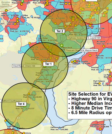
Another powerful application is demographic analysis by radius. Understanding the characteristics of a market is often just as important as understanding its size. Radius maps can be used to summarize population, household, income, age, and other demographic data within a defined area. This allows businesses to evaluate market potential, compare locations, and support decisions related to expansion, marketing, and territory design. Instead of relying on assumptions, organizations can quantify the population and economic characteristics surrounding a location before making investments.
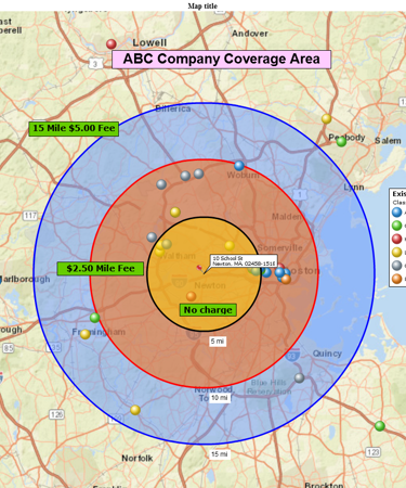
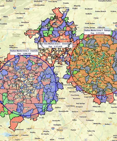
Radius mapping also supports more advanced forms of market analysis. Businesses can assess market coverage by identifying areas that are well served and areas where customers, offices, or service locations are underrepresented. Multiple radius circles can be added to a map to compare locations side-by-side, helping organizations evaluate potential store sites, branch offices, distribution facilities, or franchise opportunities. Concentric circles can reveal how customer concentration, demographics, or market opportunities change with distance from a location.
For sales and operations teams, radius maps provide a practical framework for defining territories and service areas. A radius can serve as the starting point for a sales, service, delivery, or franchise territory, helping organizations establish consistent geographic boundaries and allocate resources more effectively. Radius searches can also identify ZIP codes, counties, and business locations within a target area, providing exportable data for CRM systems, marketing platforms, and operational planning.
Multiple Ways to Create a Radius Map in MapBusinessOnline
MapBusinessOnline gives you flexibility in how you define market areas and analyze locations.
Create a radius map around a single address, customer, store, office, or ZIP code, or generate radius maps for multiple locations at once using an imported spreadsheet.
Create concentric radius rings to analyze customer reach, market penetration, and demographic trends at increasing distances from a location.
For businesses where travel matters more than straight-line distance, MapBusinessOnline also supports drive-time and drive-distance areas, helping you model real-world service areas and customer reach.
Read more about how to Create a Radius Map for One Location, Multiple Locations, Radius Rings, or Drive-Time Areas.
See MapBusinessOnline in Action
Request a demo
Learn How Our Customers are Succeeding with MapBusinessOnline
The Alternative Board (TED), an advisory board creation service for business of all types and sizes, used MapPoint to import customer locations, create and manage territories, and for visual market analysis. When MapPoint left them high and dry, they began looking for a MapPoint replacement. This process led them to MapBusinessOnline.
Over a period of a few weeks MapBusinessOnline shared several online web demo that showed exactly how MapBusinessOnline would replace and improve upon the mapping technology TED had become used to. The Alternative Board recently renewed their Map Business Online subscription for another year.
The Alternative Board

Prison Fellowship — Prison Fellowship® trains and inspires churches and communities-inside and outside of prison-to support the restoration of those affected by incarceration. PFM uses MapBusinessOnline Team Edition to create a variety of maps that track the placement of constituents and describe the demographic background of placement areas for further study and understanding.
"We love MBO, especially the ability to share maps with non-license holders for viewing!"
Business Manager
Prison Fellowship

"Very satisfied and happy with the program! Our organization was a little nervous when we found out we had to replace MapPoint. Once we came across MapBusinessOnline, we knew we had found the program for us. Not only are there many features for the map creators, there are also a lot of usable features for the individuals that receive the view-only shared maps. This is a great program and with the way our organization is changing, I have no concern about recommending it to other internal departments."
Business Manager
I-Car

Popular MapBusinessOnline features
Search data spatially with radius maps

Explore your data within circle or polygon areas. Organize search results into marketing lists or market areas. Export ZIP code demographics, territories, or marketing lists in Microsoft® Excel spreadsheets.
Use maps to create marketing campaigns

Search potential customers spatially and by demographics. Organize search results into marketing lists. Export marketing lists in Microsoft® Excel spreadsheets.
Perform market analysis for multiple sites

Search & segment data from multiple centers. Generate market area profiles. Find nearest store or pick up locations. Batch calculate distances, as well as driving times to multiple locations. Aggregate demographic data. Enrich a dataset with demographic or geographic variables.
Add drive time polygons to your market analysis tools

Create drive time polygons to identify actual market areas by hour of day and day of week. Explore your data within drive time areas. Improve direct mail campaigns.
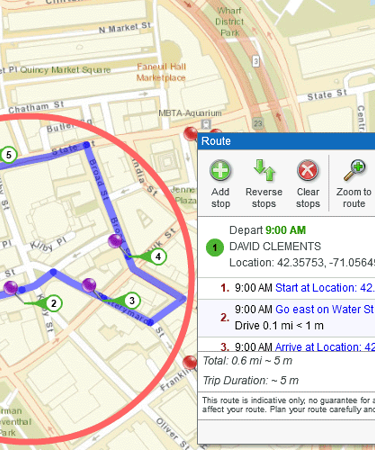
Plan customers visits with optimized routing

Use maps to identify customers within a radius or polygon. Optimize visits sequence and generate turn-by-turn driving directions. Reduce travel costs. Improve ROI and productivity.
Print large format map views

Print large maps to use in presentations and project plans. Save maps as PDF files to print as large as 60” x 60” customer maps. Supports multiple pages option to use your home or office printer for large wall maps.
Share business maps

Create interactive maps and share with friends, colleagues, dealers, customers, prospects or vendors. Share territory maps. Email saved JPEG and PNG files or embed map files in PowerPoint presentations. Includes PDF export for larger print formats.
Display business data against demographic maps

Categorize geographic areas by population or household income. Explore new markets, business patterns, or social trends against color coded Census maps for business and competitor analysis.
Create state or regional map views

Filter map view to show only selected states or regions. Create local maps that display only certain counties or ZIP codes from your market area or within a radius.


