ZIP Code Mapping Software

3 Easy Steps to Create a ZIP Code Map in MapBusinessOnline:
- Register to create a free account.
- Download and install the app (available for Windows/Mac).
- Open the app to build your first ZIP code map - map your customers and prospects by ZIP code, create ZIP code territories, or color code ZIP codes by demographic or business variables.
Get results in minutes. Most users create and share their first ZIP code territory or demographic map on their first day.
How Can You Use ZIP Code Maps for Your Business?
If you're a sales or business professional, you most probably rely on ZIP codes for designating geographic market areas and sales, service, delivery or franchise territories. It is efficient to organize strategic plans and sales tactics around common geographic administrative districts like ZIP codes and counties. With user-friendly ZIP code mapping software from MapBusinessOnline, you can easily plot ZIP codes on your maps, helping you visualize and identify key business opportunities, define account responsibilities, and identify business challenges.
- Create sales, service, delivery, or franchise territory maps by ZIP code. County, state or other district options are also available. We offer more than just Census ZCTA maps, unlike some of our competitors.
- Easily display territories that overlap.
- Create territories that reference contained population or income levels from the most recent Census demographic data.
- Plot and visualize your customers, market, and demographics by ZIP code areas.
- Apply a variety of color-coding and heat map options to ZIP code maps – both transparent and opaque.
- Expose the most lucrative markets for your product or service.
- Search imported map data by radius, polygon or drive time area. Export lists of ZIP codes along with Census data such as population and household income.
- Conduct concentric ring analysis by ZIP code area.
- Look up ZIP codes by city, county or state.
- Share interactive maps that display ZIP code areas.
- Insert map images in PowerPoint presentations or get a large format print-out of ZIP code maps.
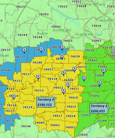
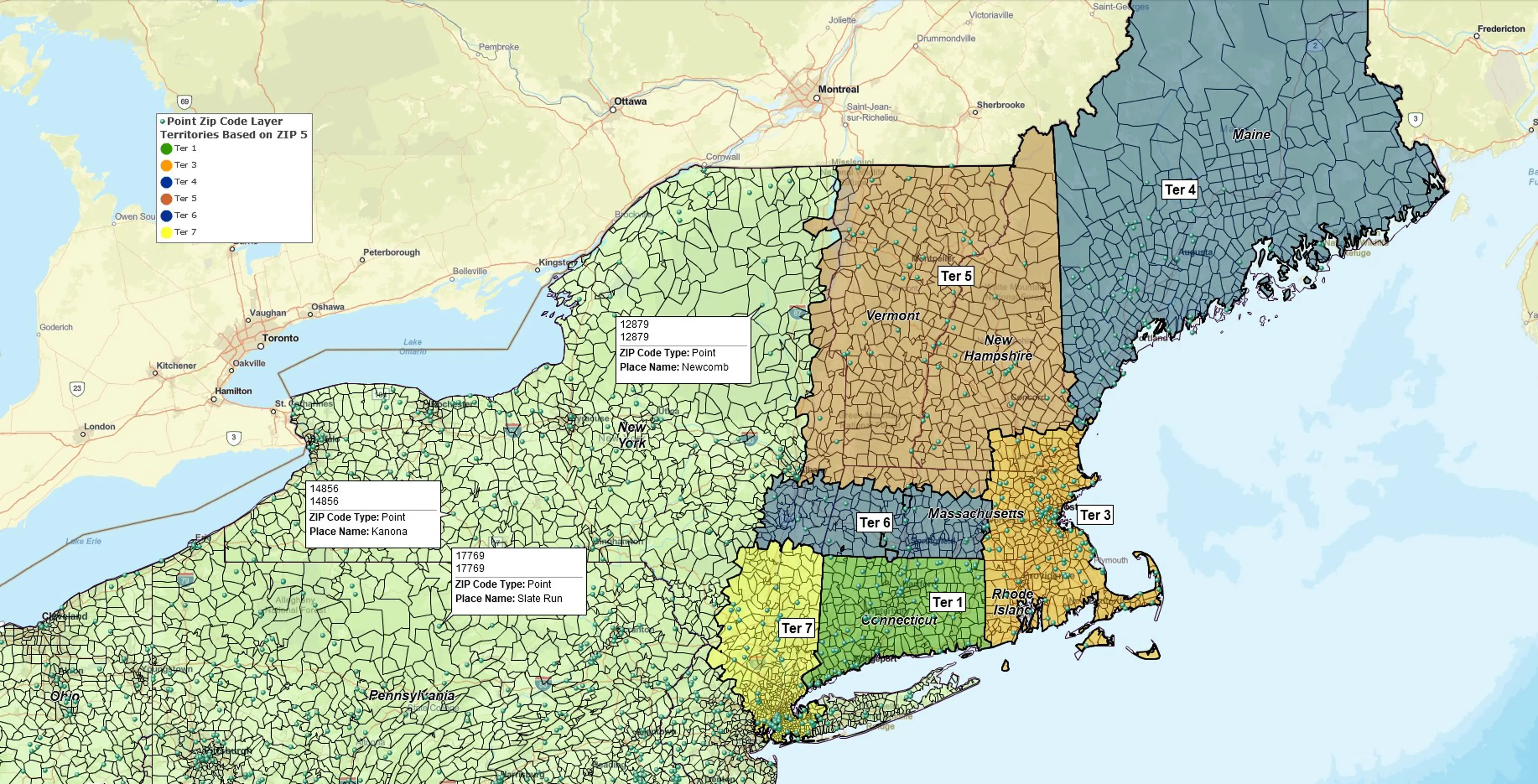
Build ZIP Code Based Territories
Be it sales, service, franchise or delivery territories, you can manage your territories on a map more efficiently than using spreadsheets or a CRM. Commercial-grade ZIP code boundaries align territories with USPS delivery areas. This is impossible with the Census-based ZCTAs used by other tools. MapBusinessOnline offers ZCTAs too, as well as point ZIP codes that have no associated area and represent mail delivery points for large facilities.
There are several easy ways to build ZIP code based territories. Import territory Excel files – or build territories right on a map. Or easily convert an area around a location into a radius, polygon, or drive time-based territory.
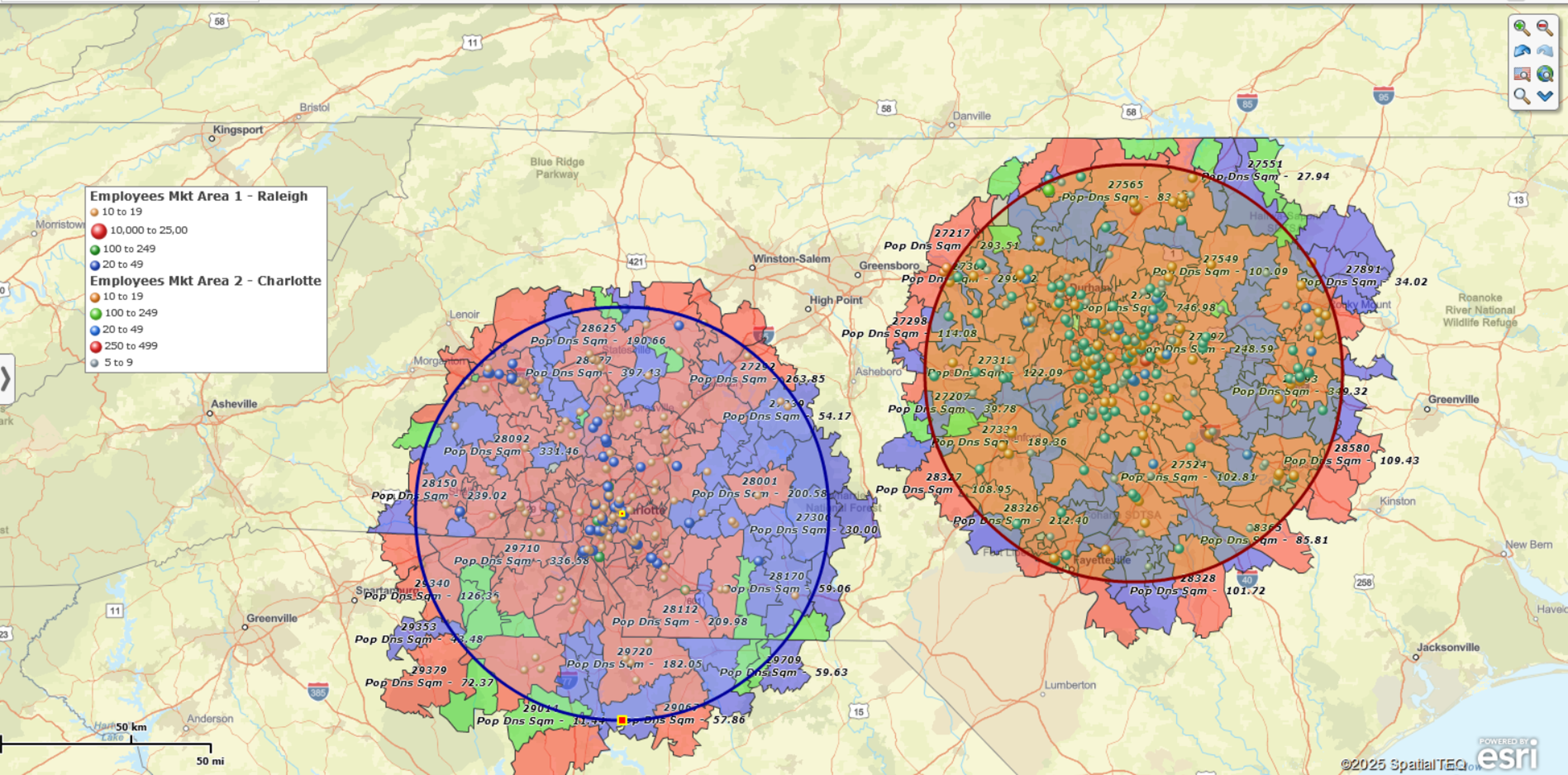
When it comes to balancing territories, using Census demographic data like population or income by ZIP code level is a very powerful tool. You can easily label ZIP codes of interest with any demographic variables, automatically calculate their totals for any group of ZIP codes, and make adjustments in the territories while observing how that translates into the total population, or household income, or any other demographic metric you are interested in.
Finally, apply color-coding, symbol coding, heat maps, labels, territory overlap highlight and more tools to make your maps more informative and power your analysis.
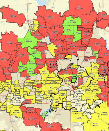
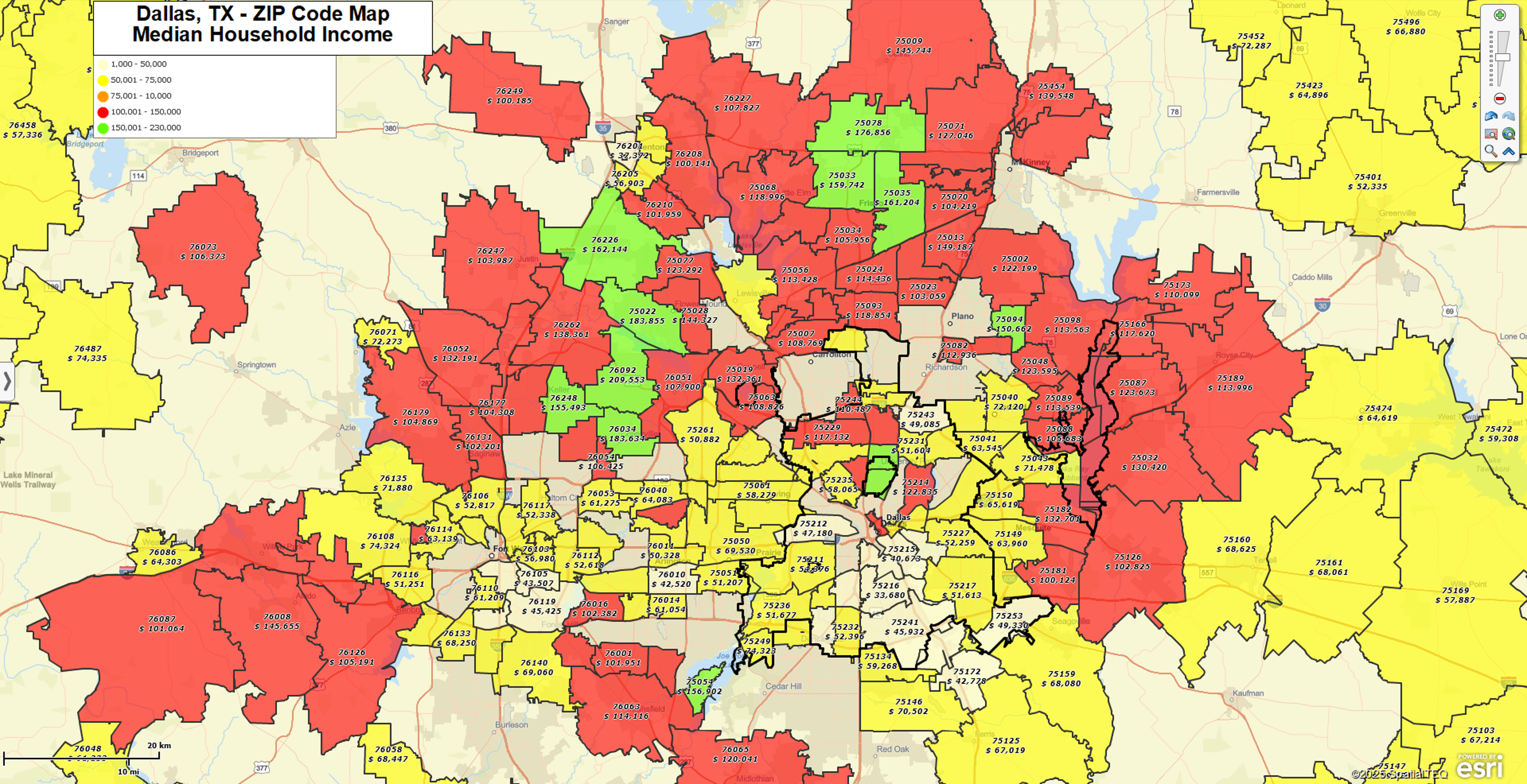
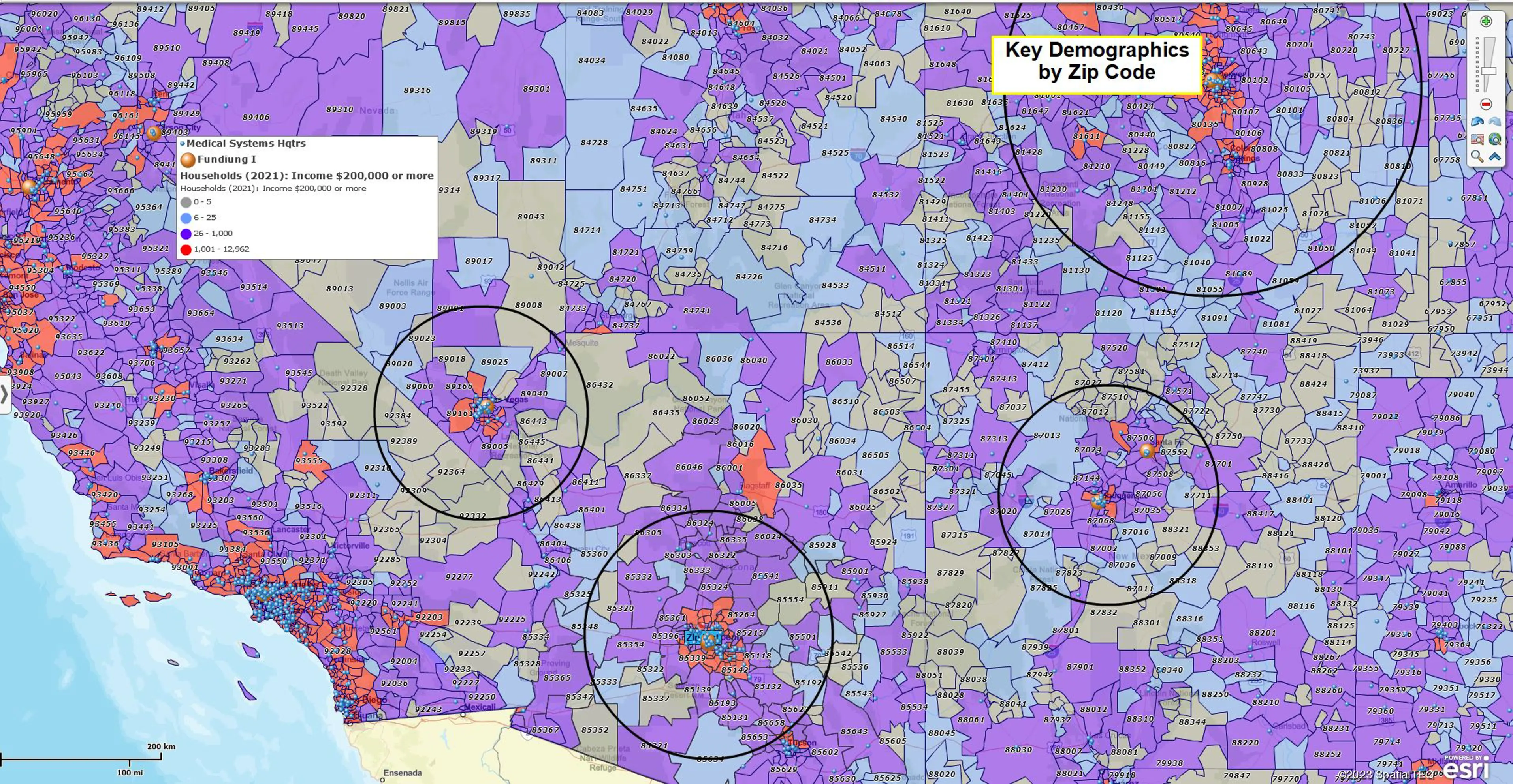
Map Demographic Data by ZIP Code
A ZIP code map is particularly useful when it’s accompanied by valuable demographic data. Our software solution gives you access to rich Census data such as population, household size, income ranges, ethnicity and so forth. It helps you identify your target market. Demographic mapping by ZIP code is a powerful tool that will give your business a leg-up over competitors without this insight.
A ZIP code heat map – a type of a color-coded map – is a terrific way to visualize the demographic data by ZIP code. It lets you assign color shades to particular ranges of population, income or other demographic value of interest, to distinguish the ZIP codes where the value is higher from those where the value is lower, “cold” to “hot” (hence the term “heat map”).
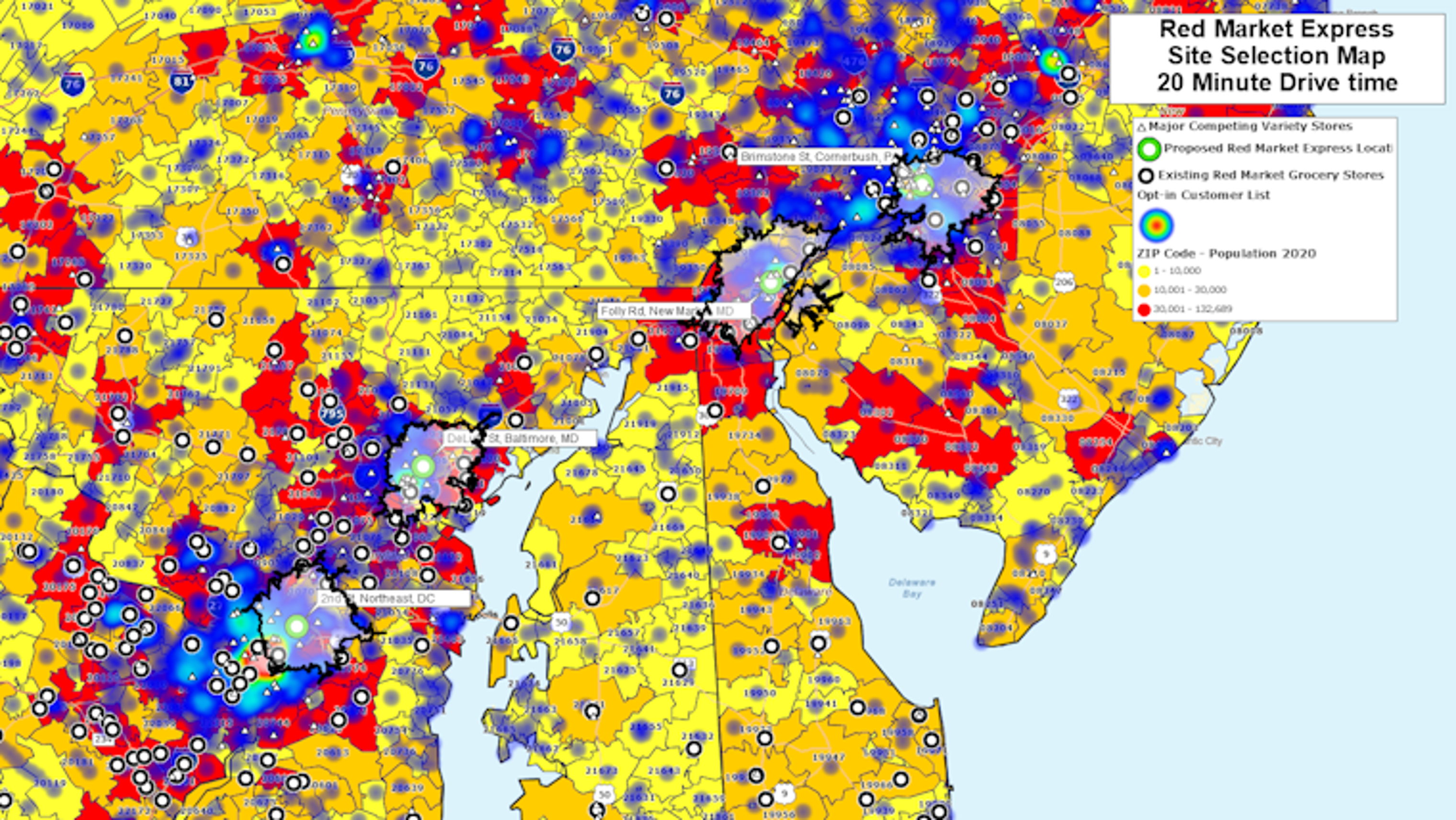
Plot Customer and Prospect Locations on a ZIP Code Map to Visualize Your Sales or Business Operations
When was the last time you conducted a thorough analysis of your business locations? MapBusinessOnline ZIP code mapping software can significantly improve your location awareness. By plotting customer and prospect locations on a ZIP code map, you'll be able to visualize the customer, prospect, sales and resource locations around your business.
You can also color-code ZIP codes to display the areas containing the most competitors. Use this information to unlock the power of location intelligence to more effectively manage your sales or business operations.
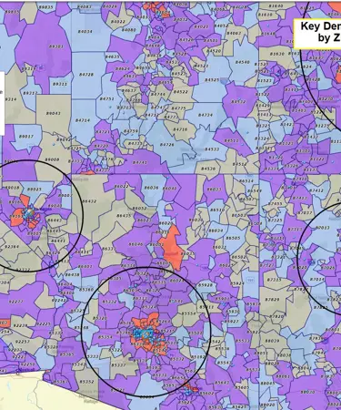
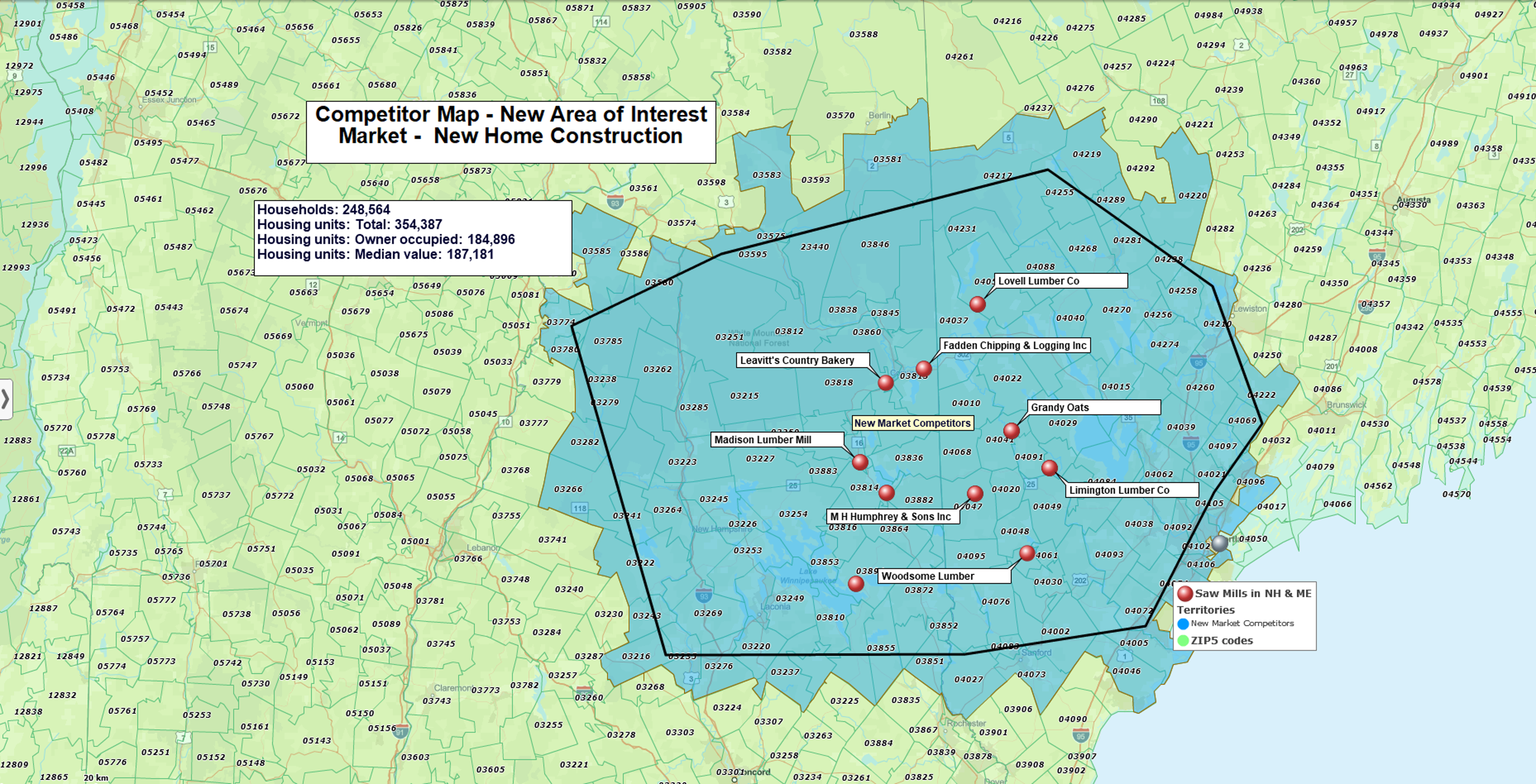
Conduct a Basic or More In-Depth Market Analysis
Our ZIP code mapping software can be a valuable tool when conducting a market assessment. For instance, you can use it to create a map that visualizes the customer or prospect distribution within each ZIP code. You can also execute a more detailed analysis by adding key demographic data to the mix – like population, income, age groups. What's more, you can also conduct a competitor analysis by ZIP code to determine areas where your competitors may pose the greatest (or smallest) challenge. This, in turn, will let you replicate successful ZIP code markets in untapped areas, which helps build reasonable business expansion plans.
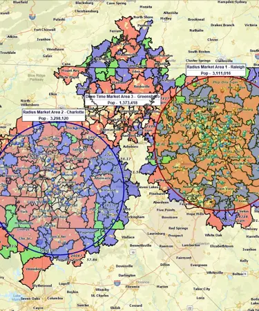
Target ZIP Codes Within a Radius
A ZIP code radius map is one of our most common applications. Sales organizations often use this feature to establish sales territories within a specific geographic region. Use our radius mapping tool to create circles at a specified mile radius from ZIP code center points. Then, instantly display or filter ZIP codes within a radius. And finally, export lists of ZIP codes from within the radius along with Census data such as population or household income.
Share Maps as Image Files, Interactive Maps or High-Resolution Printouts
Interactive maps with ZIP codes can be an invaluable asset in any collaborative decision-making environment. You can create maps that can easily be shared with colleagues and constituents as image files or interactive maps. Maps can be shared publicly or privately. This allows all key players within your business organization to have timely access to relevant mapping data to help them make the most informed, accurate decisions.
MapBusinessOnline offers multi-user account management capabilities, which enable annual subscribers to easily edit shared maps and imported data layers.
You can also create printable large format ZIP code maps that can be displayed on a wall for easy viewing.
See MapBusinessOnline in Action
Request a demo
Learn How Our Customers are Succeeding with MapBusinessOnline

"MapBusinessOnline is an amazing tool that I use every week. When you are creating zip code footprints and trying to determine what zip codes fall within a range of a business, this tool couldn't be any easier to use. There's actually so many functions that are great but specifically I use MapBusinessOnline to create either a mile radius or a drive time radius from a business location. I then use that radius to determine which zip codes fall within the radius. Why is this important? Because I then export the zip codes and use another software that gets me exact counts of how many people fall within that radius in those zip codes. It's Amazing!
I highly recommend this software!"
Chris Farcher
Account Manager
The Mailworks

"MapBusinessOnline is the only tool available that allowed our team the ability to create visual territories by zip code and then export the data into a spreadsheet. We were able to then populate our ERP system with that data/logic and create automated rules based on customer address zip codes. We cut out the manual process of inside sales entering incorrect freight delivery zones upon sales order entry. Now when sales orders are entered, we automatically populate the correct delivery zones that MBO allowed us to create. Ultimately, this is saving our company money and improving efficiency when shipping material to customers.
I highly recommend MBO, and we only have scratched the surface with what the solution can do."
Patrick Kloiber
Business Intelligence Manager
Palisades Holdings, Inc.

"MapBusinessOnline has helped my organization visualize our territories in very little time. I created maps that allowed us to see where we are doing well and where we may be struggling. Getting this information has helped us capitalize on our opportunities and build our brand throughout the country."
Elwin Warsh
Strategic Sales Analyst
The Honest Kitchen
Popular MapBusinessOnline features
Design and visualize territories

Easily create and manage sales, service, delivery or franchise territories by ZIP code, county or state. Search your business data within specified territories. Use ZIP code mapping to define your critical areas of interest.
Display business location data against demographic maps

Create ZIP code maps that display imported location-based business data against demographic maps. Explore new markets or identify business patterns or social trends that could affect your business.
Color-code maps by ZIP code, county, or state

Create color-coded ZIP code maps that enhance strategic planning and analysis through data visualization. Use these maps to conduct business analysis that compares Census demographic data at your business locations.
Search data spatially by radius or polygon area

Explore your critical business data within specific circle or polygon areas. You can also export ZIP code demographics, territory information or marketing lists filtered by the circle or polygon for use outside of the application.
Drive-time area maps

Conduct market analysis based on drive-time area around your business locations. Research competitors or customers within a certain driving time or distance of your facilities. Visually display your business’s area of operation. Create ZIP5 or ZIP3 service, delivery, or coverage area maps that describe fees by zone or area.
Share interactive business maps

Communicate sales accountability with shared interactive ZIP code territory maps. Shared maps allow colleagues to view key territory information, plan routes, conduct queries, or pan and zoom map.
Print large format map views

Our ZIP code mapping solution helps you visualize sales territories in full-color wall printed maps as large as 60” x 60”.
Start using MapBusinessOnline with no-obligations FREE trial today! It's the no-risk way to experience the many advantages of our ZIP code territory mapping product and to see if it fits your business needs. No credit card is required to get started!


