
Map Business Online provides both territory alignment tools and drive time analysis queries. These two powerful tools can be combined to define your businesses’ territory assignments in a way that supports specific business realities.
This exercise is a core feature of advanced business mapping software.
Customer Data
A good place to start is by understanding the type of customers you cater to. This will vary from industry to industry. In some cases, you may be able to specify a few NAICS or SIC codes that define the core customers in your business. In the case of retail establishments, the customer may be better defined by Census Bureau categories such as age, income level, or gender.
Whether your use industry location data, Census data, or some other customer identifier, your business map layers, like ZIP codes or counties, can be easily appended with industry or demographic data. This means your analysis will support a definition of your most critical customer types.
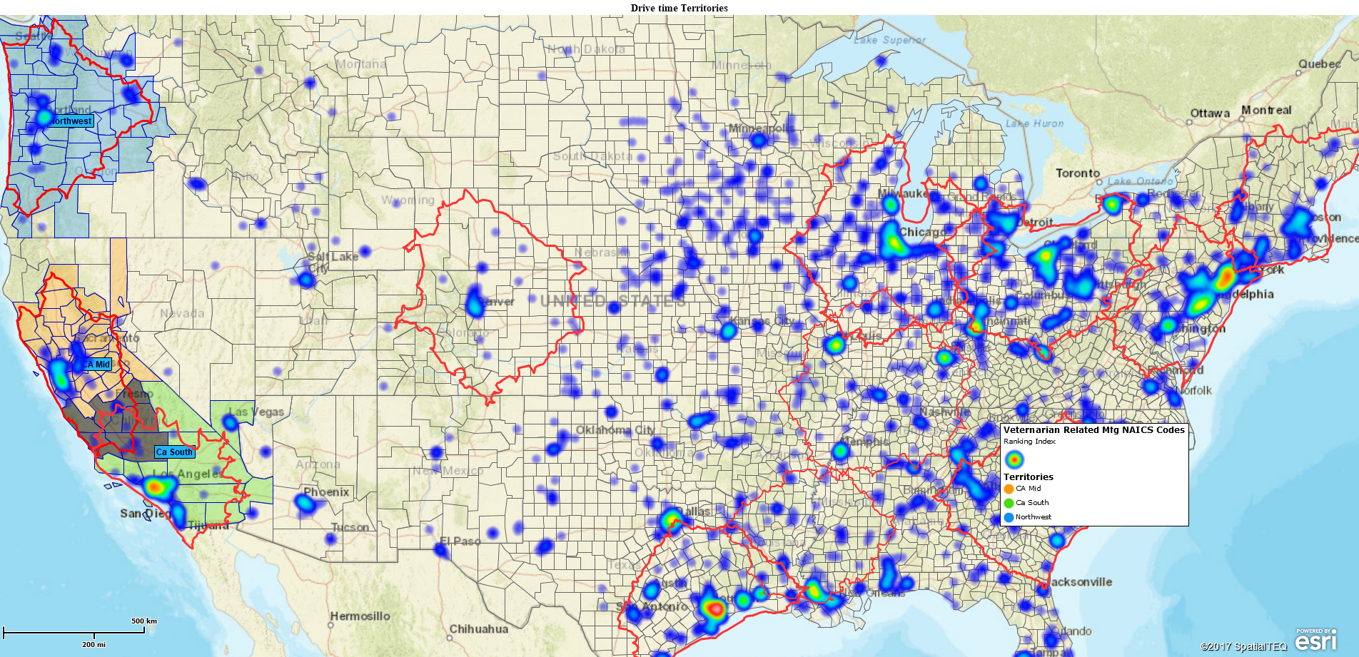
Often a simple heat map view of customer types by industry or customer address data can be used to highlight the specific regions that harbor the majority of your customer activity. Such areas should be located at the center of your territories.
Drive Time Polygons
Drive times can be used to define the coverage areas of traveling sales people and inside sales people. Drive time is sometimes referred to as windshield time. How much time behind the wheel does your company feel is reasonable for a traveling sales person? How many ZIP codes should an inside sales person be responsible for? You decide.
For many companies that driving time allowance may be less than an hour. Sales managers want their sales people interacting with customers not driving. For other companies, especially those selling expensive systems to corporate customers, a four-hour drive time might be fine if it gets the sales person in front of the right decision maker.
For more operationally focused companies, efficiencies are a primary concern. For example, insurance companies may create field based territories with specific driving time ranges. They’ll want as many field claims filed as possible, all investigated within a time frame. Travel costs will be tracked carefully to avoid out of control expenses.
By assigning drive time areas, businesses are limiting the travel time of their employees based on experience and situational awareness. From that drive time polygon on the map, a territory can be easily created that assigns ZIP codes, counties or Census tracts to specific individuals as areas of responsibility.
For retailers drive time may be more a function of how long it takes a prospective customer to drive to their location. An ad in the Sunday Paper might interest a customer until they realize it’s a forty-five-minute drive. Realistic drive times may vary by retail product. A single mom may be willing to drive no more than ten minutes to pick-up a pizza but up to a half hour to take her kids to an indoor playground.
Drive time polygons may or may not make sense for your company’s territory models. But, if you’re raising an eyebrow as you read this blog, give the drive time concept some thought.
Beginning to create territories out of DT polygons
Drive time Territories
The real beauty of drive time designated territory assignments is the ability to overlay related business data such as sales or purchasing activity, travel expenses, prospects and customer inquiries, field data collected, and many other types of business data. Connecting a territory to a drive time helps control expenses, measure customer response times, and communicate company expectations.
The Map Business Online workflow is straight forward. Import and display the customer data you want to work with – NAICS codes by ZIP code or customer location data – then heat map that data to show the areas of maximum sales intensity. Use those high intensity areas as your territory center points.
Select the Map Business Online drive time polygon tool. Place a point in the center of an area of high intensity. Choose the drive time timing that works for your team – it could be 60, 90, 180 up to 480 minutes. You decide. Execute the drive time query.
Resist applying the resultant polygon to query a territory for a while. Click the search option wizard close and simply review your map. Repeat this exercise for all your key areas. You decide how many drive time polygons to construct based on:
- The number of traveling sale people (currently or in the future)
- Your understanding of your key business areas
- Major metropolitan areas
Once your drive time polygons are created take some time to look over the map. Discuss it with your team and ask questions like:
- Are we adequately covering our key areas of business?
- Are there any areas of significant overlap? How do we manage those areas of overlap?
- Where do your existing sales people start their day in comparison to your drive time polygon center points?
Once you’ve considered your new map, take the time to create territory areas out of the drive time polygon network you’ve created. Click the polygon then choose the Blue Puzzle piece icon which allows you to select ZIP codes or counties as a territory basis. Remember to give those territory areas some transparency by using the slider control associated with the Territory Layer in Manage Map and Data.
The process of creating drive time based territories will inform your business. You’ll be considering key geographic markets, travel expenses, sales staffing, and the business’s future’s goals and objectives.
Let us know what other things you learned through this process. Drive time territories can become the individual measuring stick by which businesses can determine what progress is being made toward goals, how healthy the sales team is, and is the business growing or declining.
NEW! Refer a business associate to Map Business Online in exchange for a $20 Amazon Gift Card!
Find out why over 25,000 business users log into www.MapBusinessOnline.com for their business mapping software and advanced sales territory mapping solution.
Contact: Geoffrey Ives geoffives@spatialteq.com or Jason Henderson jhenderson@spatialteq.com (800) 425-9035
MapPoint users please consider www.MapBusinessOnline.com as your MapPoint Replacement.
Please read customer reviews or review us at Capterra, G2Crowd (LinkedIn connected), or at the Salesforce.com AppExchange.