MapBusinessOnline is an interactive geographic web map of the United States or Canada. It allows map subscribers to overlay relevant map layers and create business map models that describe their particular business systems.
Business models include sales territories, franchise territories, customer maps, prospect maps, market analysis, expansion planning maps, and field service maps.
Designed to improve upon the Microsoft MapPoint user interface, MapBusinessOnline is easy to use and has provided thousands of professionals with affordable access to business mapping software. To get started, import your location datasets (address or latitude/longitude data) into the mapping application. Here’s another helpful resource for map creation using MapBusinessOnline.

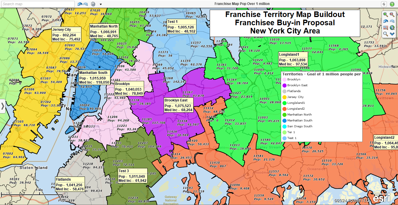
A franchise territory map balanced by Census Bureau population data.
Example industries that regularly use MapBusinessOnline include:
- Construction – Site planning, job site monitoring, and vehicle routing.
- Franchise businesses – Franchisee territory planning, sales planning, and franchise mapping.
- Healthcare – Field clinician mapping, hospital systems planning, and healthcare market analysis.
- Hi-tech – Field service territory mapping, market analysis, and expansion planning.
- Insurance businesses – Sales mapping, territory mapping, market analysis, and field claims mapping.
- Manufacturing – Sales mapping, territory management, hierarchical territories, and expansion planning.
- Large and small Retailer – Marketing campaign management, territory mapping, and expansion planning.
- Sales & Marketing – Territory management, marketing campaign tracking, and map visualizations.
Additional map layers available to MapBusinessOnline map creators include:
- Client location data – customer and prospect address lists, patient address lists, store locations, and many other business location-enabled datasets.
- Optional additional map layers – ZIP codes, counties, states, city limits, and Census tracts.
- Ancillary datasets – Census Bureau demographic data, Business Listings, and calculated data sets generated within MapBusinessOnline from other datasets.
Imported location data points can be converted to optimized vehicle routes with up to 150 stops per route. They can also be used to create customer map visualizations that visually describe where customers are located and their point density across a larger map view.
Territory Mapping Support
MapBusinessOnline sales, franchise, or service territories are created from map layers – ZIP codes, counties, city limits, or states. Territory mapping support includes:
- Territory spreadsheet import.
- Territory creation by on-map selection.
- Hierarchical territory support – Regions, Divisions, Zones.
- Territory overlap controls.
- Territory balancing functions.
- Export ZIP codes segmented by territory.
Basic How to Videos
Click here for a quick recorded MapBusinessOnline web demonstration. For a live demonstration, possibly using your business data, contact MapBusinessOnline here.
Resources for learning about MapBusinessOnline and how to create effective business maps are listed below:
- MapBusinessOnline help and technical support center.
- General articles focused on how to accomplish business mapping tasks with a lookup index.
- MapBusinessOnline’s pricing and features page.
- MapBusinessOnline case studies.
- Our YouTube video library of helpful mapping processes.
Contact us options:
- 1-800-425-9035
- Request a live web demo.
- JHenderson@spatialteq.com GeoffIves@spatialteq.com
- Use the Chat function at MapBusinessOnline.com
Read reviews and view MapBusinessOnline comparisons on G2:
- G2 Awards for 2024


