
Importing a spreadsheet of location data and viewing those locations against a web map is the first thing most new MapBusinessOnline users do when they log on. The business mapping function of importing data can be described in multiple ways:
- Geocoding – that’s the official geospatial industry term for the data import process
- Pinning – this is the term that has been coming up a lot lately. Think ‘pin the tail on the donkey’
- Plotting Excel Data – a common search term for the functionality
- Importing Location Data – a more descriptive way of saying it
MapBusinessOnline makes the importing of location data wicked easy. Here’s a blog I wrote a while back describing the import process, with a video included. Even the Free Trial, free mapping software, imports Excel spreadsheets with up to 1,000 records.
Business Listings are also available in MapBusinessOnline, see the Yellow Pages Icon on the master toolbar under search tools. Business Listings may also be symbolized by you crazy business mappers.
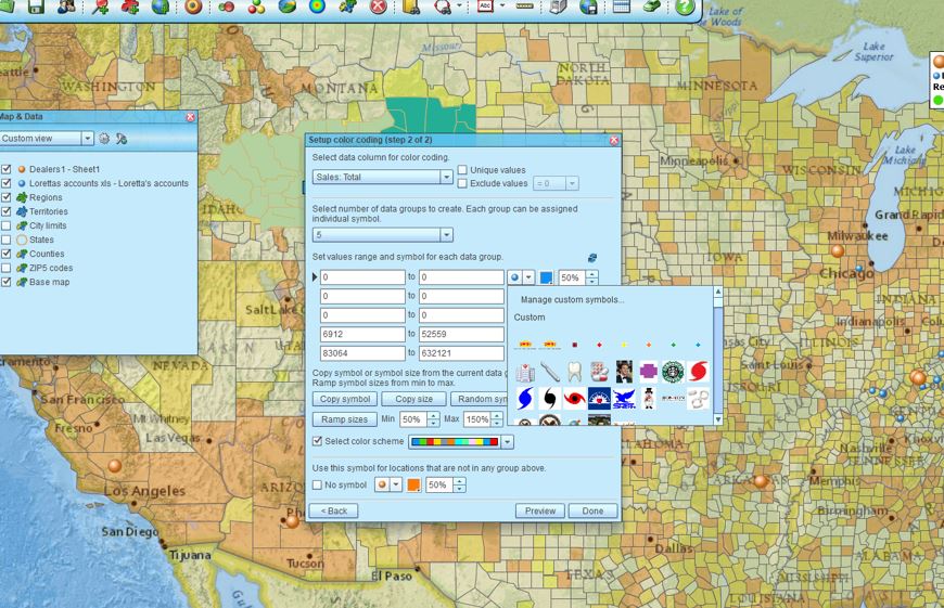
Once the data is imported into MapBusinessOnline and displayed on the map, the user may choose to adjust the symbols that are automatically applied by the tool upon import. This is done by clicking the Color Code Points button on the toolbar and using the color-coding process, including the symbol library. Read more about color-shading points.
Import and Display Your Custom Symbols
Once you enter the symbol library there is an option to import your symbols. The first thing you should do is find or create a group of symbols to use on your business map. Keep the new symbols small in file size and save them in Jpeg or PNG format. The symbol file size must be no larger than 50 KB.
- From the Color Code with Symbols button (three colored balls) on the Master Toolbar, select your data and begin the standard choose symbol process
- Click any symbol listed in the dialogue page to open access to the symbol library
- Once in the symbol library, scroll to the top using the scroll bar on the right side of the dialogue page
- At the top click into the Mange Custom Symbols button
- Click the Upload a Symbol button and navigate to where the symbol is located on your machine or network
- Select and import your new symbol. The symbol will be saved in the custom symbol library panel located just below the custom symbol buttons we just used. You’ll note that you can select and delete symbols as well
Accessing the Custom Symbol Import function
Tweak Your Symbols to Achieve Map Perfection
Realize that your custom symbol may not appear on the map exactly as you might have envisioned. It may require a couple of design passes to get your symbol just right. Keep those symbols small and succinct. You will have the option, once the symbol is placed on the map, to move the symbol around the geocoded point on the map, like a position on a clock face. You’ll see that position adjustment feature in the label or callout on the map.
You can also use the Edit Address and Location function in the Data Window to adjust your plotted location position. Sometimes users are more interested in the custom symbol positioning on the map than the accurate locations of the originally imported data points. In the Data Window, select that imported data layer, then hover your mouse over the very left column – the one that displays the colored geocoding accuracy dots. Click the Pencil when it pops up. Next, select the option to Edit Address and Location.
Custom symbols and symbols sets are useful for specific industry applications. Medical symbols proliferate. And because we may not be intimately familiar with your specific industry, we can’t decide which symbols make the most sense for your applications. Let us know if there is a symbol-set we should be supporting. We’ll consider adding it to the library of stock symbols, so you won’t have to bother to import custom symbols.
I’ve used custom symbol sets in MapBusinessOnline maps to display hurricane landing and impact zones, hospital area descriptors, and even dental services. There must be an endless requirement for more map symbols based on specific industries.
Users may want to import custom symbols in support of territory mapping, demographic analysis, or market analysis for expansion planning.
______________________________
We recommend users access MapBusinessOnline via the downloadable Map App.
The Map App install is fast and easy. The Map App is a cloud-based service, once you’ve logged in you’ll have access to all of your previously saved maps and data. The Map App is a better user experience and provides access to more features than the Web App. The Flash-based Web App link will remain available until December 15, 2020.
The Map App includes the new Map Viewer app for free non-subscriber map sharing.
Value-Added Resellers – Offer the tool to your customers as a reseller. Make money on training and consulting. Contact us with further interest in reselling MapBusinessOnline.
Win a $20 Gift Card! Refer a business associate to MapBusinessOnline in exchange for a $20 Amazon Gift Card!