Comparing Radius and Drive Time Maps
Radius and Driving Time searches are commonly used geospatial search approaches within MapBusinessOnline. Each data search tool has its advantages.
MapBusinessOnline Standard offers both Radius and Driving Time and Distance search options under Search Tools on the Master Toolbar.
MapBusinessOnline Pro includes all Standard capabilities and offers extended Radius and Drive Time mapping capabilities through the Analysis Button on the Master Toolbar.
Radius Search
Selecting the Circle or Radius option from the Search Tools drop-down generates a basic radius search. Place a center point on the desired location, and select the circle’s radius distance by dragging your mouse cursor or adjusting the radius length in the Properties dialogue box that pops up.
But why generate a radius search to begin with?
A circular area or radius spatial search is an organized way to view data. Radius searches also reveal trends in data, such as customer purchase patterns or disease trends in the field.
Radius searches are more straightforward than a driving time or distance-based search. A circular shape or radius object is placed on the map, and the area it covers is searched for data. A driving time or distance polygon must also account for the travel along the road network. The resultant shape of the area is based on the calculation of driving time or distance. This means we must consider distance traveled along all roads, speed limits across all roads, and even turn restrictions across all roads in all directions.
Radius searches can be easily duplicated on a map view. A map creator can copy the radius search and plot the same search at a new location. Concentric ring searches provide extended radius searches – first a 1-mile search, then a 5-mile search, and so on.
Radius searches are also faster than polygon and free-form searches. The map creator doesn’t have to be so exact. Drop a point, stretch the circle to the desired size, and go. Polygons and random shapes can be messy, unintentionally grabbing areas and data outside the intended space.
Data searches are similar to physical searches. Radius searches in standard lengths keep things consistent across a map. Of course, there may be times when a varying search radius is applied. A polygon search tool might work better around significant geographic obstacles. It depends on the circumstances. For instance, mountains and highways can complicate real or virtual searches for things or data.
A consistent radius search area can provide relevant results when analyzing or comparing demographic data. A five-mile radius search in New York City will display very different results from a five-mile radius search in Bingham, ME, which is how it should be—a reflection of population density. In the case of New York City versus Bingham, ME, the population density is staggering different based on a consistent 1-mile radius.
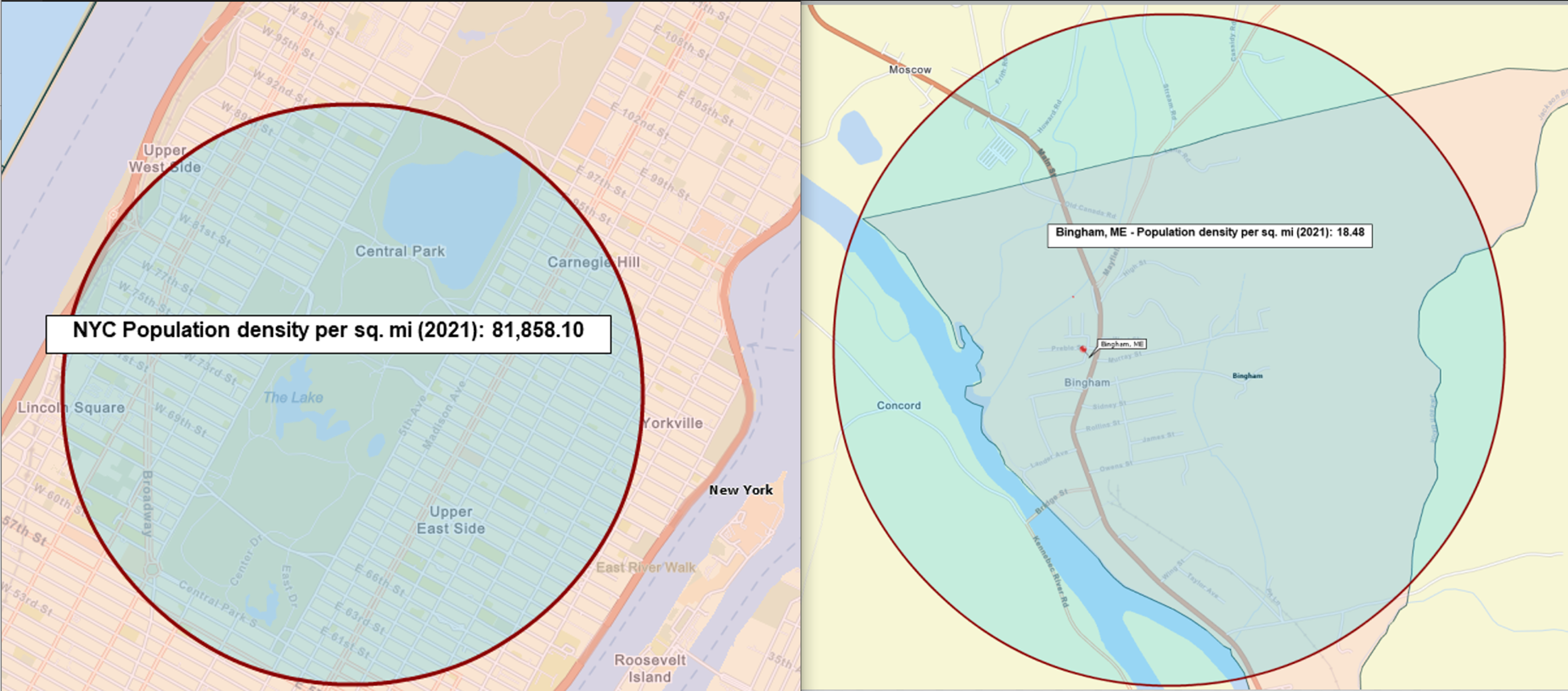
New York, NY – 1-Mile Radius Search Population Density – 81,858.1
Bingham, ME – 1-Mile Radius Search Population Density – 18.48
These were calculated using MapBusinessOnline radius search and US Census Bureau Demographic Data.
Drive Time Searches
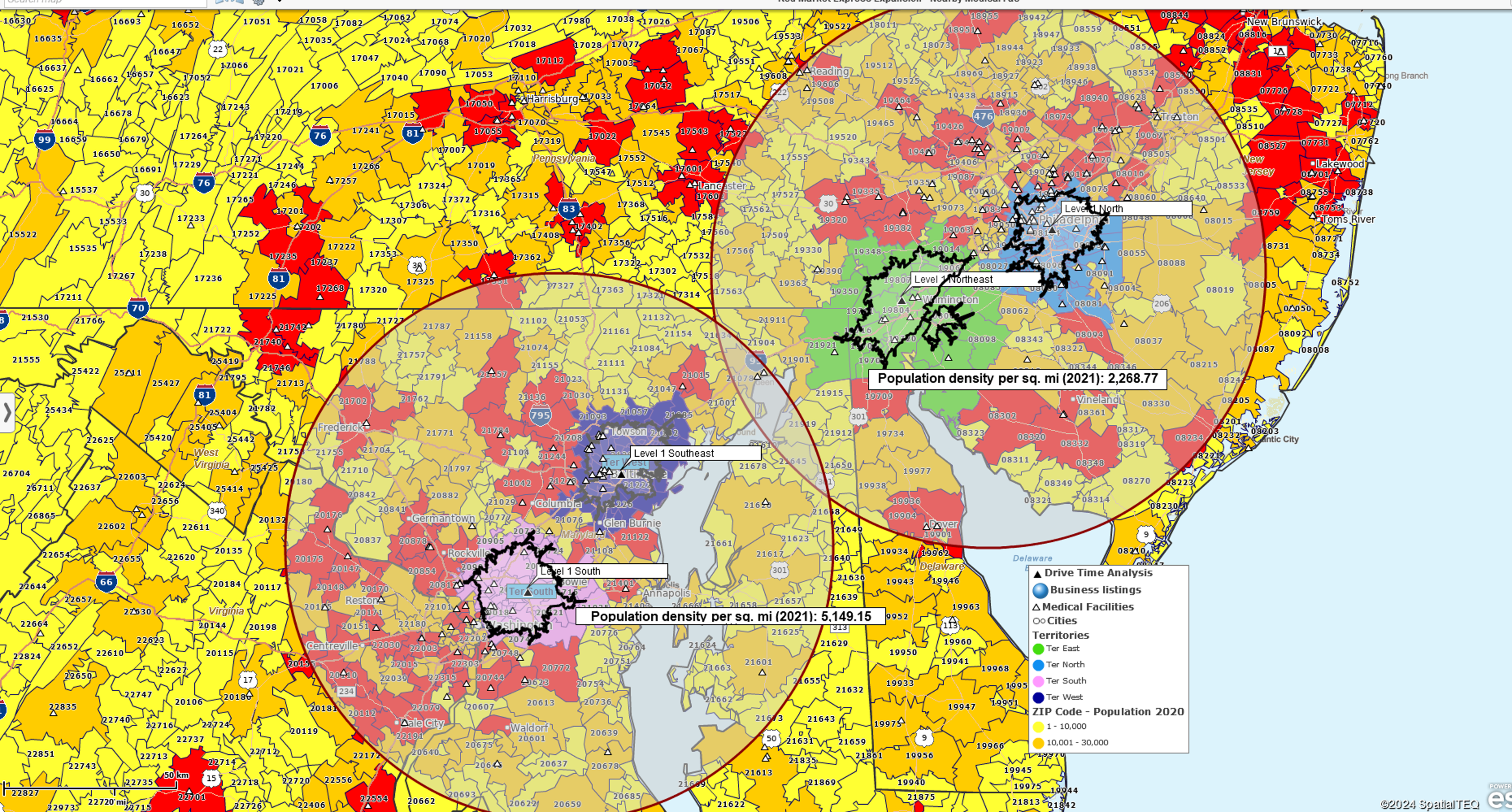
In MapBusinessOnline Standard and Pro, Drive-Time searches, as mentioned above, are a more complex alternative to Radius Searches. The user still searches an area for imported location, demographic, or geographic data within a defined area. But instead of a circular area, a drive-time area is generally a jagged polygon that reflects the area encompassed by a vehicle’s potential travel perimeter in all directions over a given time.
Drive time configurations consider road speed limits, one-way/two-way restrictions, highway classifications, and time of day traffic. So, where a radius search defines a 5-mile circular area, a driving distance search shows the map view of the area covered if a vehicle traveled five miles along the road network in all directions. Likewise, a driving time search shows the area covered if a car traveled along the road network for five minutes in all directions.
Driving time search results gather data within a driving time or distance polygon. These dataset query results in MapBusinessOnline could report imported demographic and geographic data.
Retailers like drive-time searches for defining and analyzing marketing campaigns. Driving times help define core audiences for campaign messaging, for example, the assumption that a family won’t drive further than a 20-minute drive time for pizza or miniature golf.
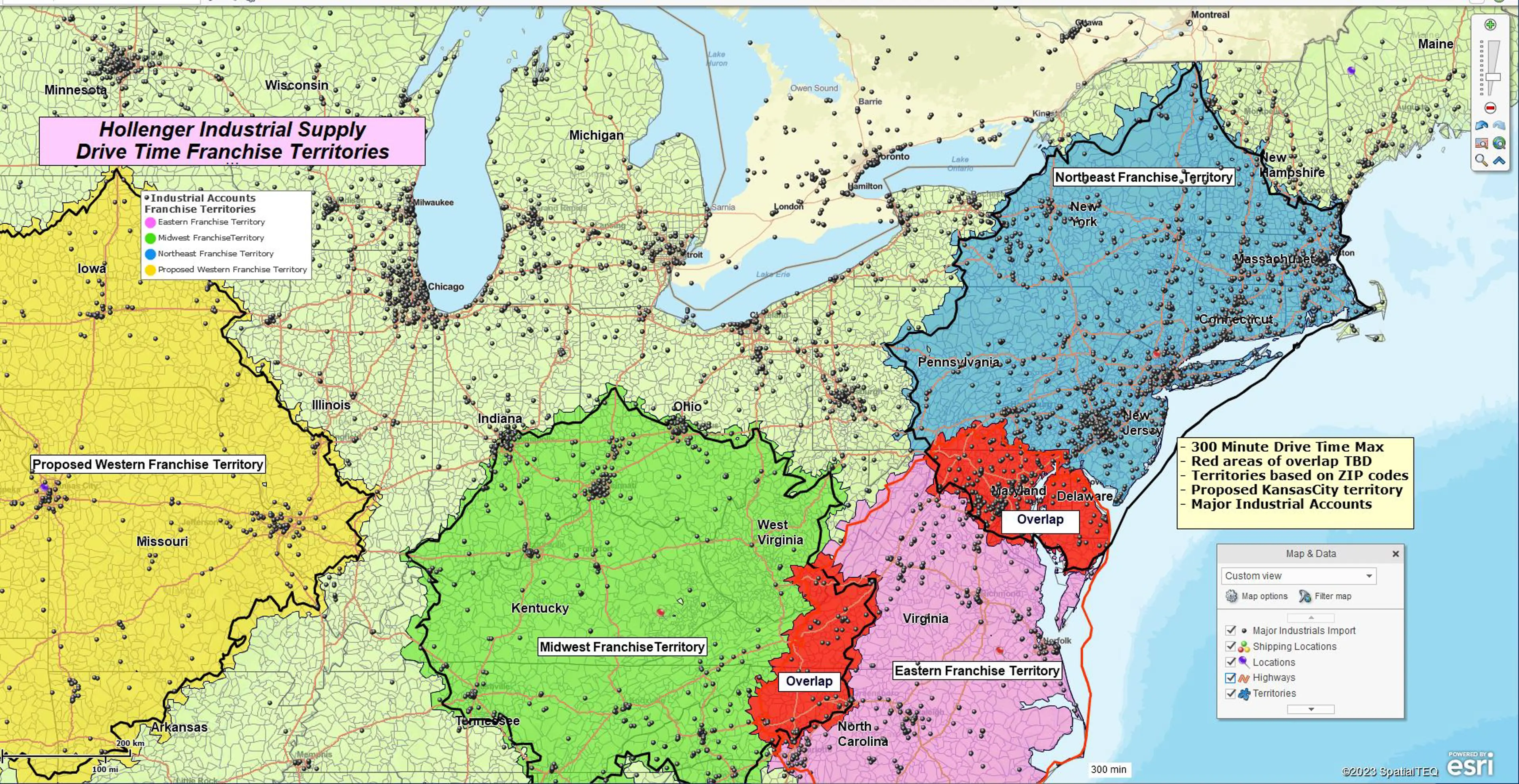
A manufacturing sales team might use drive time analysis to define territory areas based on the sales representative’s start-of-day locations and maximum driving distance. This is a common method for balancing territories and keeping workloads and compensation fair.
Logistics managers use driving time and distance searches to determine optimum travel pathways for supply chain transportation networks.
Facility operations planners use driving time searches to calculate the most effective new locations for warehousing, stores, or light manufacturing facilities.
MapBusinessOnline Pro enhances the drive time search capability of MapBusinessOnline Standard by offering multiple center point searches, origin-destination batch analysis, and comparison of multiple datasets for driving time and distance results.
In many mapping situations, both radius searches and driving time and distance searches can be used on the same map. Drive time polygons might be used to create territories or areas of interest related to a highway. A general radius search could provide relevant demographic data for the map viewer on the same map.
As always, business mapping tools serve your map’s business purpose. Use them wisely and avoid superfluous clutter on your map.


