
Last week, MapBusinessOnline version 7.3 was released. Any subscriber to MapBusinessOnline can access the new features listed below by running the Map App’s ‘MapBusinessOnline Updater’ option from the Windows Start Menu or the Mac Applications Folder.
The Updater updates your business mapping software to the latest release. You will need to log out of MapBusinessOnline to run the Updater.
Below are the four major features included in the 7.3 release.
Color Control for Map Object Highlighted Selection
Until now, when a MapBusinessOnline user selected a Map Object – a ZIP code, county, state, territory, or city limit – the object becomes highlighted in bright Yellow. With the 7.3 release, that Map Object highlight color is selectable.
Map creators can go to Map and Data, select Map Options, and select a new color under the Geographic/Territory Selection color box option.
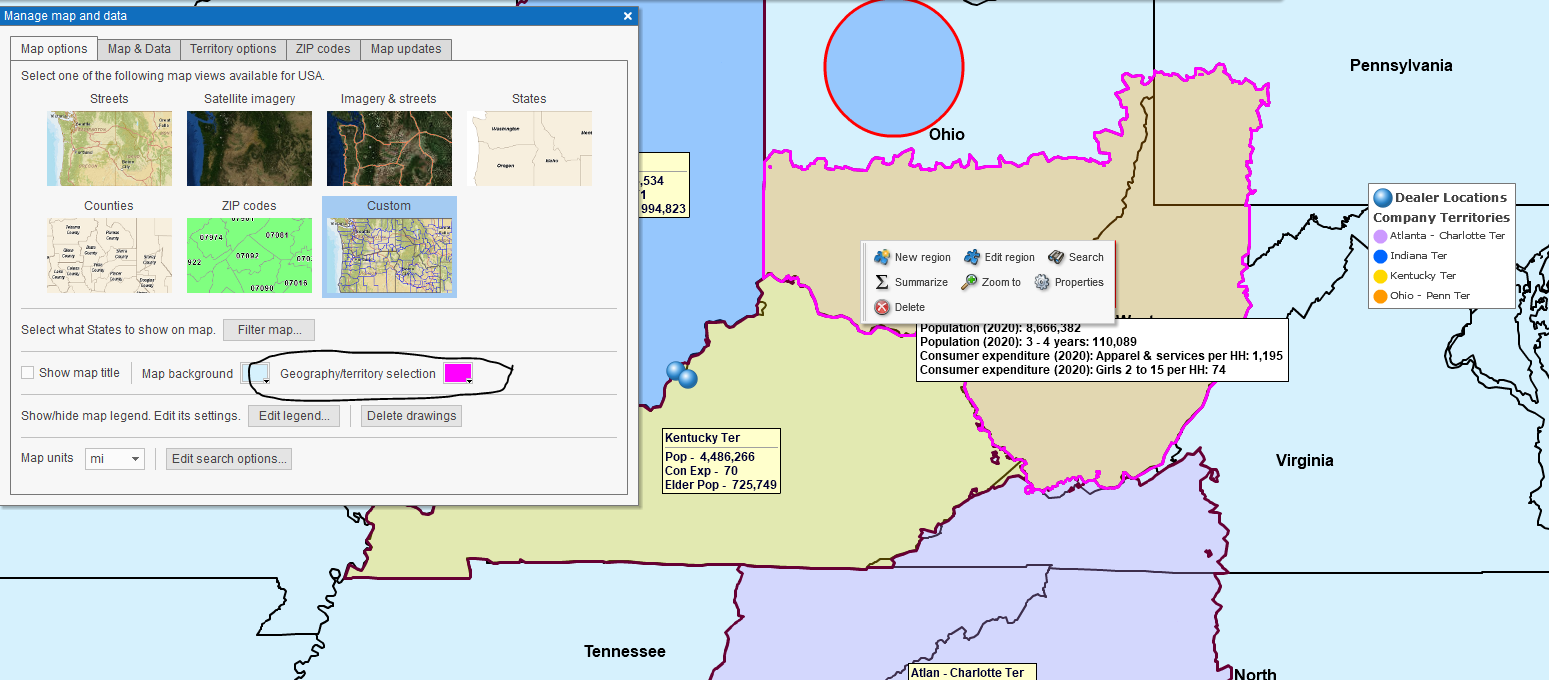
Color Control for Highlighted Map Object Selection
Easy Export of Boundary and Point ZIP Codes
As many MapBusinessOnline territory mappers have discovered, USPS ZIP5 Codes come in two flavors: Boundary and Point ZIP codes. Boundary ZIP codes are the classic ZIP code areas we all remember as kids. Boundary ZIP codes have an area with a boundary. Point ZIP codes, on the other hand, do not have an area. They represent extensive facilities like hospitals or military installations that constitute a one-stop drop-off point for bulk mail deliveries.
Currently, there are 33,309 Boundary ZIP codes and another 7,688 Point ZIP codes. (Remember this for Jeopardy.) Until now, to access the complete list of all ZIP codes by type within MapBusinessOnline, the map user had to upload the complete file from Public Data under Datasets. Not the worst thing in the world, but it did add 40,000 location records or more to your map work (MapBusinessOnline’s limit for Standard is 50,000.)
With this month’s 7.3 release, to secure the complete ZIP code list, a map subscriber may export the ZIP5 code map layer using the Export button on the far right of the Data Window toolbar. The user has multiple options for export:
- Add Point-only ZIP codes to the export of the ZIP5 codes (boundary ZIP code).
- Export only ZIP code records assigned to a territory.
- Segment exported ZIP code data records by territory.
For many of you, this new feature will be sweet relief. Exporting all ZIP codes for tracking sales and other business operations by ZIP code generally mandates that it includes ALL ZIP codes.
The feature saves a series of steps and avoids adding 40,000 records to your map data, which can be tricky for those of us importing large datasets under 100,000 records per map limit.
The Public Data folder’s complete ZIP code list will remain available.
Quick Summary Button Demographic Reporting by Territory
MapBusinessOnline began offering summary button data reporting by specific map objects, like circles and polygons, several years ago. With the 7.3 release, the MapBusinessOnline subscriber can access the summary button for fast demographic reporting AND place ten subject lists of demographic data columns directly on a territory map.
Summary provides immediate access to demographic data and a dropdown option for the inclusion of imported data columns. The Summary Button appears as a menu button when the map object – drawn object or territory – is selected. The resulting spreadsheet is limited to ten rows but can be exported or placed on the map for map viewer reference.
Such quick and easy reporting lets a MapBusinessOnline subscribers quickly mix their business data with Census Bureau demographic subjects. The Data Window territory analysis view is always available for more in-depth reporting using the Change Columns button. Read more about Change Columns here.
Calculated Data Columns Now Supports Scripting
MapBusinessOnline includes the Calculated Data Function that enables simple mathematical formulas to be applied using columns of data associated with specific map layers. Calculated Data Columns are map layer-specific. That means a user would set up a recipe for the ZIP code layer or the County layer – not both.
With the release of 7.3, MapBusinessOnline Calculated Data Columns now supports scripting. Click the embedded link to read more about scripting. Most of us have a vague understanding of scripting and its impact. If you have nerdy developers interested in your business mapping tools, this new feature is for them.
Calculated Data Columns sum related demographic layers. For example, users can sum the population of elder Americans across the five again population demographic layers.
MapBusinessOnline Release 7.3 is an excellent example of features being added to the product because customers requested them. Keep those cards and letters coming. Or email us through the contact button on the website or at either of the emails noted below.
_______________________________________________
Discover why over 25,000 business users log into www.MapBusinessOnline.com for their business mapping software and advanced sales territory mapping solution. The best replacement for Microsoft MapPoint happens to be the most affordable.
To access MapBusinessOnline, please register and then download the Map App from the website – https://www.mapbusinessonline.com/App-Download.aspx.
After installing the Map App, the MapBusinessOnline launch button will be in the Windows Start Menu or Mac Application folder. Find the MapBusinessOnline folder in the Start Menu scrollbar. Click the folder’s dropdown arrow and choose the MapBusinessOnline option.
The Map App includes the Map Viewer app for free non-subscriber map sharing.
Please read customer reviews and review us at Capterra, or g2crowd
Contact: Geoffrey Ives geoffives@spatialteq.com or Jason Henderson jhenderson@spatialteq.com