
MapBusinessOnline provides America’s best sales territory management software. Thousands of business mapping users across North America use MapBusinessOnline territory management to:
- Motivate and organize their sales efforts.
- Manage field staff providing clients with repair services.
- Develop franchise sales territories based on key demographic categories.
- Build hierarchical territories supporting regions, divisions, and zones.
- Generate map-based market analysis where territories define areas of success and point to new markets.
The software offers informative map visualizations of territories based on a preferred map layer – usually ZIP codes, city limits, counties, and states. The most popular alignment layer for territory construction is the ZIP code layer.
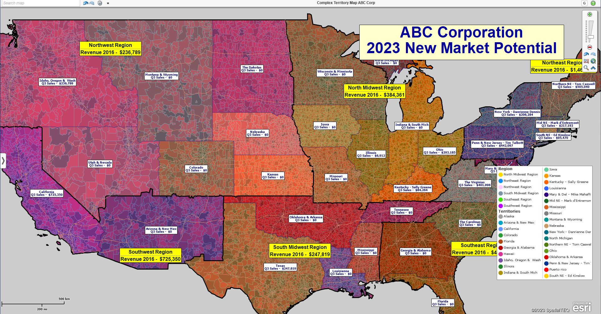
A nationwide territory map created using MapBusinessOnline.
Territories can be created manually by cursor-selecting, polygon-lassoing areas on the map, or filtering for specific ZIP codes. Learn more. The territory map creator can import territory spreadsheets for instantaneous territory creation. Once established, territories can be edited as required:
- To correct errors – nobody’s perfect.
- To add or delete territory areas.
- To make a specific territory larger or smaller.
- To switch ZIP codes for whatever reason.
- To adjust fill color and border properties.
- For label adjustments and data appends.
A few weeks back, a chatting user asked how to identify ZIP codes not assigned to a territory. This is a great question and deserving of more in-depth study.
ZIP Code Territories
Zip code-based territories in MapBusinessOnline follow the identical sequences for creation and editing as county, state, or other map alignment layer territories. So, you can apply what you learn in this article to counties and different territory assignment layers.
Once a territory map is created, a territory layer is presented in the Data Window view. The Territory layer, data dropdown, ZIP codes, and all other map layers are selected from the left side.
The problem of identifying ZIP codes not assigned to a territory can arise under various circumstances, including:
- Running a business query – ZIP code searches are conducted to answer a customer question, and a territory name is required. Call center associates often look up ZIP codes.
- Generating additional territories – New territories must be created from unassigned ZIP codes.
- Sales and business analysis – Sales activity by ZIP code happens and necessitates a ZIP assignment to a territory.
Old School Visual Approaches
What are the options for finding unassigned ZIP codes not associated with a territory? First, there’s the age-old ‘look at the map’ approach. This is strictly a visual process. Zoom to the ZIP code and scan the map view for the associated territory. It’s old school, but it’s also pretty easy if the map is optimized and not too complex.
First, make sure your territory map is optimized for visual inspection. Keep the ZIP code layer turned on in Map and Data. Use Map and Data layer tools to make the ZIP code layer between 50% and 80% transparent. Adjust the ZIP code boundaries to a darker color for better visibility. Do the same optimization to the Territory layer, keeping the color and line thickness slightly different than the ZIP code layer for differentiation. Learn more about map optimization.
Keep other layers like States and Counties turned off or unfilled with color. There’s no need for additional distractions.
In the Search Map box in the upper left-hand corner of the application – above the Master Toolbar, enter the ZIP code number and click the Binocular icon to the right of the search box. The map view will zoom to the center of the ZIP code in question. Pan back using your Navigation Scroll Bar in the upper right corner of the map, and you’ll eventually see the territory color bounds.
You won’t see any territory-related color except ZIP codes if the Territory is unassigned. Generally, a territory will show a territory color (referenced in the Map Legend) and a territory label. TIP – You can hold down the Control Key and click on the territory to retrieve a missing label. Sometimes labels get turned off.
Another visual approach is simply viewing an area and selecting a ZIP code on the map with your cursor. If the ZIP code is not assigned to a territory, it will show as selected, highlighted in Yellow. (You can configure the selection highlight color in Map and Data options.)
If the ZIP code is assigned to a territory, MapBusinessOnline will present the Select Geography option dialogue box that lets you choose between the ZIP code and the Territory. Bingo! Right there, you know it is assigned to a territory.
Use the Data Window
The Data Window presents a tabular view of all data within any MapBusinessOnline map. Click the Data Window button on the right side of the Master Toolbar to open the tabular view.
Select the Data Window Territory Layer on the left dropdown for territories based on a ZIP code map alignment layer. Click the mini-Data Window icon to open a specific territory and see all the assigned ZIP codes for that territory. You can use the Filter By Code search bar to look for a particular ZIP code.
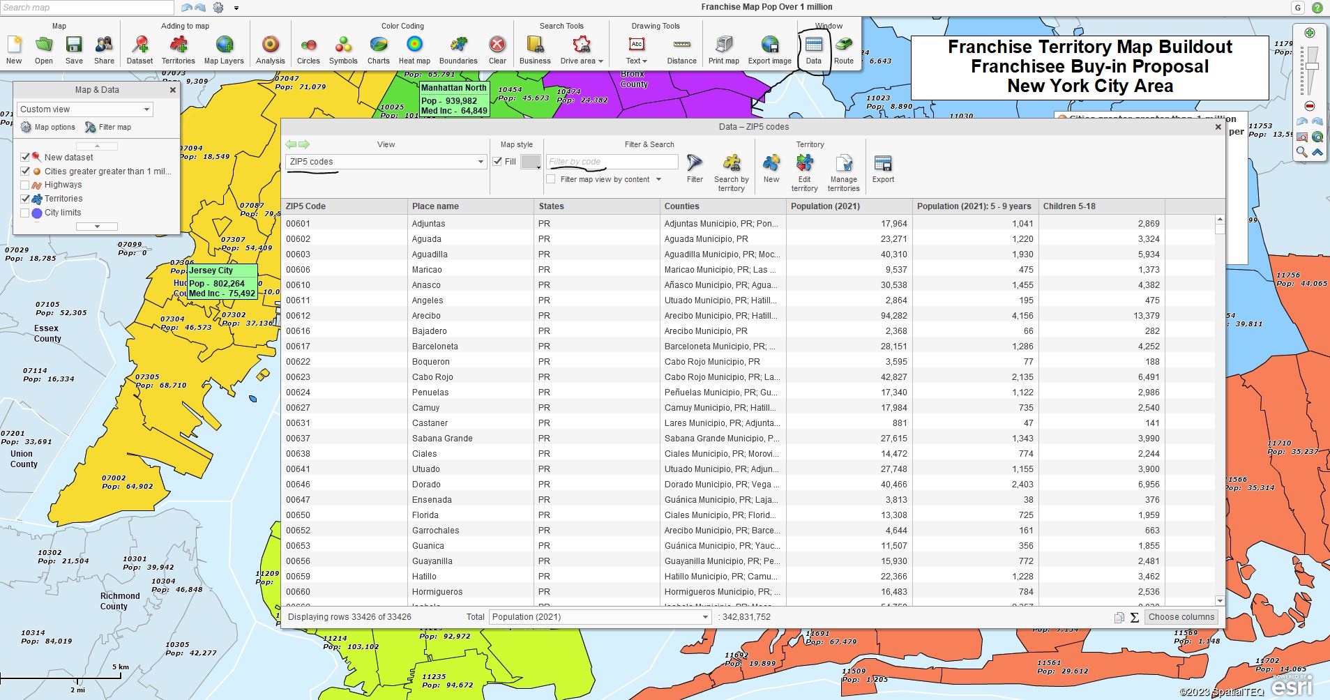
The Data Window with the Filter by Code Search Bar.
Filter the ZIP Code Layer for Territories
Here’s our preferred search method for ZIP codes left unassigned by territory, using the Filter button.
First, realize you can focus your Filter operation by State. In the Map and Data Box, click the Filter Map option and select the states you prefer to focus on. This will limit the number of ZIP codes presented to just those states of interest.
- Select the ZIP code layer in the Data Window view.
- In the lower right, click the Choose Columns
- On the left side of the data organizer, under
General, find the Territory and Territory Count. Move the Territory and Territory Count options to the right side. This adds columns to the Data Window territory view. - Note: You can now Click the header on either Territory column to arrange the data in descending order. This view can be helpful.
Back in the Data Window, the Filter function is accessed through the Filter and Search section. Click the Filter icon (a funnel.) This opens a dialogue with access to MapBusinessOnline imported, demographic, and geographic data on the left. And with access to modifiers and value inputs on the right.
- Click the filter button. Select Territory or Territory Count. Choose the < Less Than modifier and click Filter.
The results will display all ZIP codes without a territory assignment.
If your territory map covers only a few states, you can see why the State filter can help. Without it, you’ll be wading through 47 states of ZIP codes. Use the Data Window toolbar’s Filter by Code box to quickly search for the ZIP code most important to you.
The approaches described above are ways to use a business map to search for any location data. ZIP codes are commonly used, but you might be looking for counties, Census tracts, or some other element in your imported location data. Play with the filter button options to get familiar with the filtering process in MapBusinessOnline. Sooner or later, you’ll be looking for something, and these Filter functions may be your best approach. Learn more.
_______________________________________________
Discover why over 25,000 business users log into www.MapBusinessOnline.com for their business mapping software and advanced sales territory mapping solution. The best replacement for Microsoft MapPoint happens to be the most affordable.
To access MapBusinessOnline, please register and download the Map App from the website – https://www.mapbusinessonline.com/App-Download.aspx.
After installing the Map App, the MapBusinessOnline launch button will be in the Windows Start Menu or Mac Application folder. Find the MapBusinessOnline folder in the Start Menu scrollbar. Click the folder’s dropdown arrow and choose the MapBusinessOnline option.
The Map App includes the Map Viewer app for free non-subscriber map sharing.
Please read customer reviews or review us at Capterra or g2crowd.
Contact: Geoffrey Ives at geoffives@spatialteq.com or Jason Henderson at jhenderson@spatialteq.com.