
MapBusinessOnline Pro answers proximity questions for businesspeople who manage data – lots of data. Pro is used by transportation companies, banks, large retailers, insurance companies, and healthcare organizations, to name a few industries.
MapBusinessOnline Pro allows map creators to import up to 250,000 location records per map. Location records are generally business addresses but could be latitude and longitude coordinates. Learn more.
Proximity analysis enables an assessment of the location data surrounding a specific point, a set of points, or an area on the Earth. One could also think of proximity analysis as a critical tool for situational awareness. Proximity analysis and spatial searches enhance business intelligence leading to healthier growth, more market share, and a more attractive bottom line.
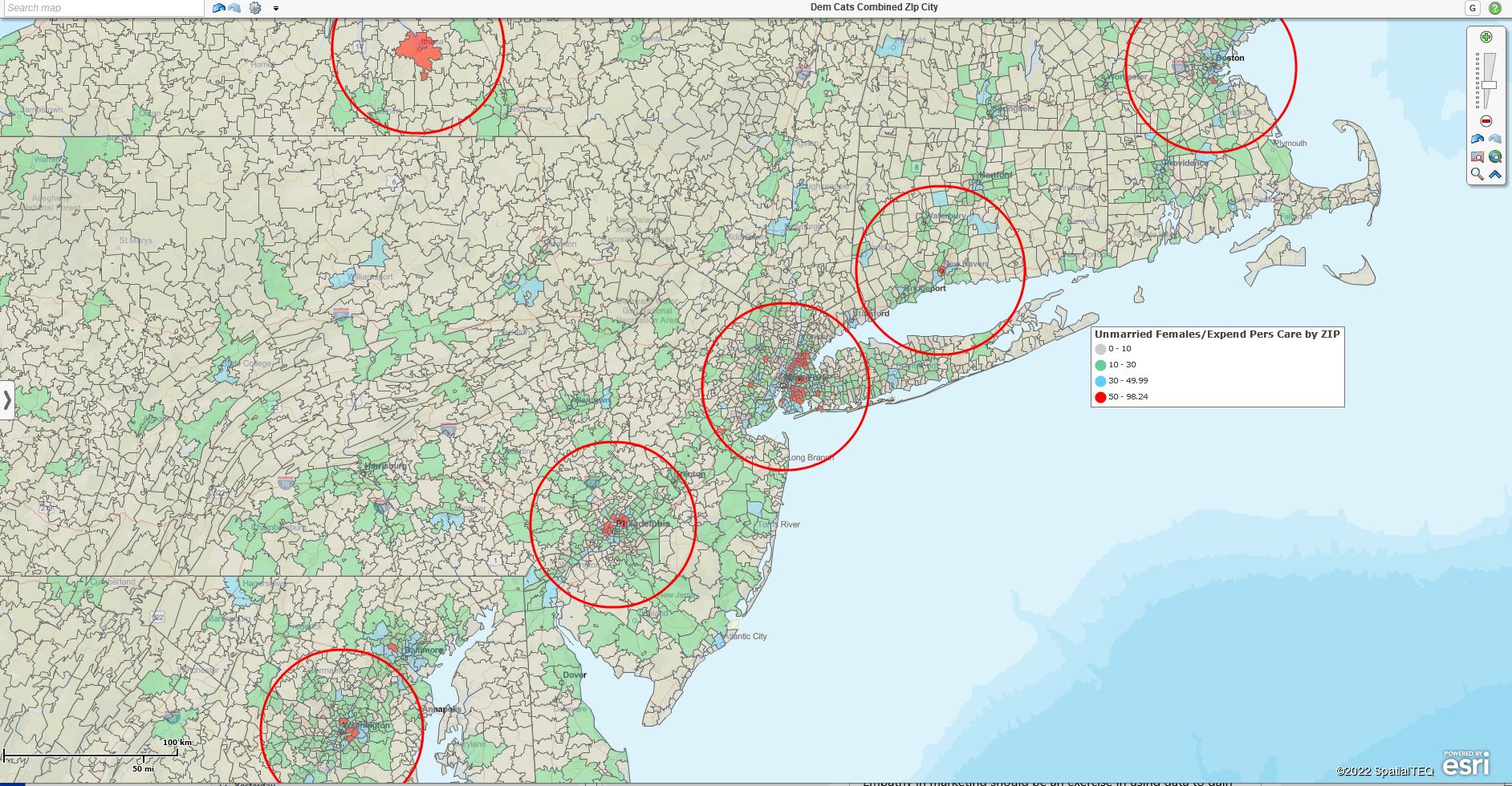
Best Potential New Market Areas Circled for More Research.
In MapBusinessOnline Standard, proximity analysis gathers all of the records within a specified radius or driving distance/time of a given central point. In MapBusinessOnline Pro, map users can extend proximity analysis by reporting on the distances (straight line or driving distance) from Point A to a set of points B(x)to B(y). The added benefit for MapBusinessOnline Pro users is the software’s ability to calculate driving distances and driving times along a road network. You map creators will look long and hard for a cloud-based mapping software that conducts driving time and distance queries for less than $1000.00. Let me know if you find one.
Radius searches applied to a business map are typically set to a specific radius to capture all of the location data within that radius-defined circle. For example, a business map user could specify a ten-mile radius, drop a central point on the map with their mouse cursor and query the map for data. Examples of queried data vary depending on the industry of the subscriber but could include:
- All homes for sale within ten miles.
- All medical facilities within ten miles.
- All customers within ten miles.
- All prospects within ten miles.
- All bowling alleys within ten miles.
The possible location targets are endless. Download additional data sets using MapBusinessOnline Business Listings for a small fee.
MapBusinessOnline Pro
Proximity analysis in MapBusinessOnline Pro enables a whole new array of proximity search features. Pro introduces the ability to compare two datasets of points and calculate the distance between all points in both data sets. These calculations generate three levels of proximity:
- Straight line distance – as the crow flies from Point A1 to Point B1.
- Driving distance – the distance driven across a road network.
- Driving times – The time it takes to drive the distance across the road network.
MapBusinessOnline Pro features are located in the Market Analysis button along the master toolbar. Proximity Analysis results vary from function to function.
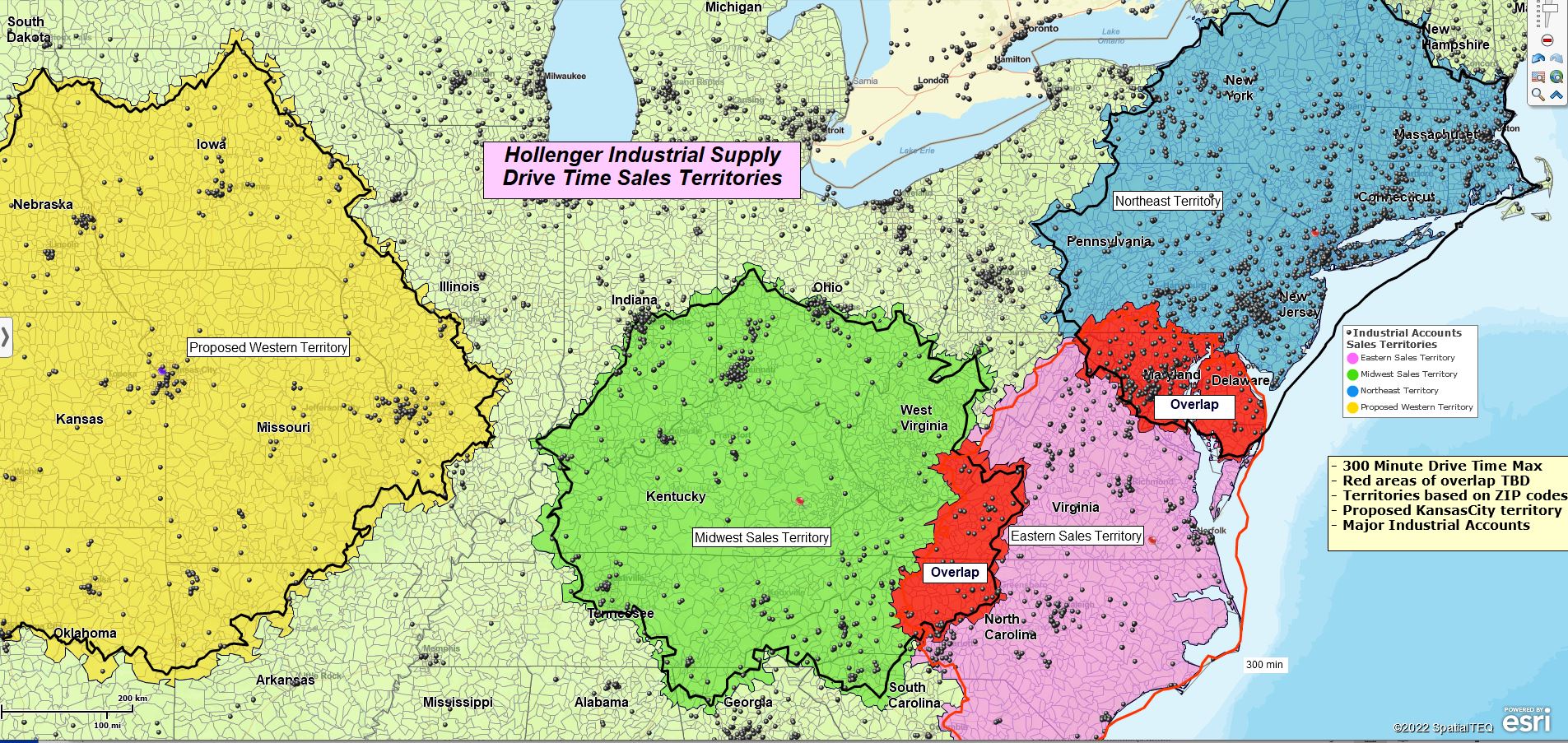
Driving Time Polygons Created Using MapBusinessOnline Pro.
Search & Segment Data – Create marketing lists by searching all points in a dataset based on a selected radius, reporting the results for each radius in either Straight distance, Driving Distance, or Driving Time. Instead of marketing lists, the map creator could request that territories be created from map layers.
This function is excellent for organizing lists of proximity results arranged by distance or time from each point. A practical example would be delivery planning, where the number of stops in a 10-mile radius could represent a full truckload.
Batch Calculate Distances or Times Between One or Two Datasets – With this proximity query, a map user can analyze all distances between all points – straight, driving, or time – and collect the results for totaling.
Users apply this calculation to transportation systems to assess maximum systems costs or delivery time estimates given a set of addresses. Many users use this tool to conduct ZIP-code to ZIP-code analysis to gauge the efficiency of a transportation network.
Find the Nearest – Another perspective on Proximity analysis is finding the nearest locations from one set of data to another set of locations. At the risk of sounding redundant, we’re looking for the closest twenty locations. In MapBusinessOnline instructions, we tend to use Customers to Store as the classic example. So the result would be a set of up to twenty stores nearest to a dataset of customers.
It could go the other way, too, to find the nearest twenty customers to this set of stores. All results can measure Straight, Driving Distance, or Driving Time. You can set a maximum distance or time as well.
Find the Nearest results will add a column to the relevant datasets in the Data Window. You’ll have the opportunity to add a little bit of defining text for the heading, which will also display Driving Distance or which analysis you chose to apply
Other examples of how this query is used in the field:
- Finding the nearest hospitals or emergency centers. Especially interesting in times of high traffic, which can impact the calculation.
- Find the nearest ATM – There are many reasons why the nearest cash machine might be essential to a process – some good, some bad.
- Find the nearest automobile inspection station – A tribute to Willbur Holmes, VP of Sales at Holmes Distributors in Portland, ME. Wilbur regularly scanned the parking lot with binoculars from his office to determine which employees had expired or were close to expiring registration or inspection stickers. Wilbur would then notify you of your faux pas, avoiding inevitable incarceration for semi-innocent people.
A growing number of businesses are taking seriously the study of location data and proximity analysis. Realize the power that location analysis, driving time and distance calculations, and map visualizations can add to your business intelligence. Join the party. Get the power. Purchase or upgrade to MapBusinessOnline Pro.
Read more about the difference between MapBusinessOnline Standard and Pro.
_______________________________________________
Discover why over 25,000 business users log into www.MapBusinessOnline.com for their business mapping software and advanced sales territory mapping solution. The best replacement for Microsoft MapPoint happens to be the most affordable.
To access MapBusinessOnline, please register and download the Map App from the website – https://www.mapbusinessonline.com/App-Download.aspx.
After installing the Map App, the MapBusinessOnline launch button will be in the Windows Start Menu or Mac Application folder. Find the MapBusinessOnline folder in the Start Menu scrollbar. Click the folder’s dropdown arrow and choose the MapBusinessOnline option.
The Map App includes the Map Viewer app for free non-subscriber map sharing.
Please read customer reviews or review us at Capterra or g2crowd.
Contact: Geoffrey Ives at geoffives@spatialteq.com or Jason Henderson at jhenderson@spatialteq.com.