
“Honey, what do you say we Batch Calculate some drive times and distances tonight?”
“Um. Sure. Wait. What did you say?” Not another night of driving time and distance queries. Next time don’t marry a map geek. Oh well.
What exactly is batch calculating distances and times across one or even two datasets? One might ask.
Well, for one thing, it is a feature in MapBusinessOnline Pro. You’ll find it listed as option two under the Market Button, short for Market Analysis. The list of functions includes multiple takes on driving time and distance analysis. MapBusinessOnline Pro takes business mapping software to a whole new dimension.
Specifically, Batch Calculate, the second function listed, analyzes a list of address points compared to one address or a second list of addresses. That comparison calculation returns a result of the distances or travel times between all those location points. The ‘batch calculate’ computation results show as additional columns to the original address spreadsheet in the Data Window.
A batch-calculated analysis of addresses are valid for any business interested in controlling travel costs, fuel consumption, delivery times, and transportation efficiencies. These businesses might include:
- Delivery Services – Regional or citywide delivery services via truck, car, or bicycle must monitor service levels, travel costs, and driver locations.
- Retail Distribution Channels – Retailers are dependent on reliable and efficient Just-in-Time delivery systems to control inventory, monitor turn and earn rations, and maintain customer satisfaction.
- Supply Chain Management – Similar to warehousing but more global. Multiple distribution destinations with 24/7 incoming product requirements and outbound commitments.
- Technical, Medical, or Sales Field Staff Monitoring – Mobile field force tracking of expense reporting, travel costs, fuel consumption, miles traveled, or even stop-off times.
- Warehousing Operations – Multiple warehouses feeding raw materials to a factory or storing finished goods.
With MapBusinessOnline Pro, a systems analyst can import a spreadsheet that includes one section for Origin Addresses and another section for Destination Addresses. Batch calculate takes these two sets of data, analyzes all points, and compares all addresses returning both time and distance results. Think Shipping for Origin and Receiving for Destination.
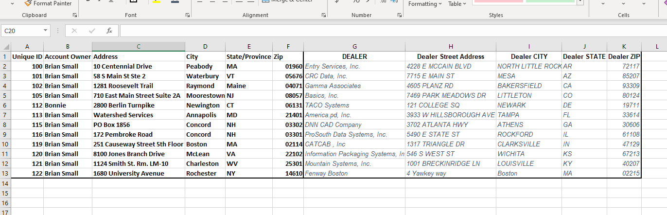
Example Spreadsheet with Two sets of Addresses.
As an example, a delivery service manager could use the time results to measure or correlate:
- On-timeliness averages for the delivery force.
- Fuel consumption – based on miles traveled.
- Miles traveled vs. expected miles traveled – expense tracking double-checks.
- Stop-off duration expectations vs. time spent per route stop.
- Total miles across the network.
From One Point to All Other Points
A map user runs Batch calculation operations in MapBusinessOnline from one point to all points in a data set or from a selected point on the map:
- Select an imported or plotted point on the map.
- In the associated pop-up menu, choose the option for Distances and Times – a bullseye icon.
- In the menu that pops open, select the dataset you’d like to calculate against.
- Select the time and distance operations or combination operations you desire.
- Type in a textual suffix for the Column Header of the results spreadsheet.
- Click Next. Review the status report of routing credits.
- Run the Batch Calculate query.

Here’s an example output view from the Data Window after Batch Calculate happens:
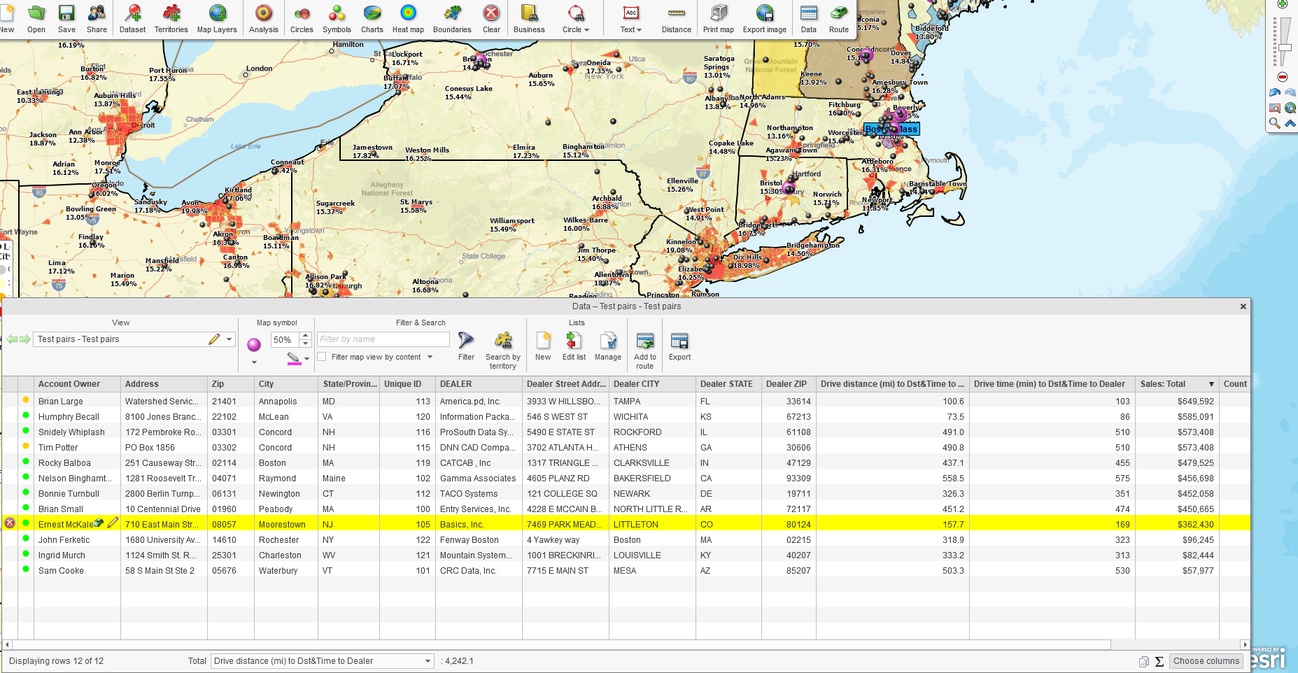
Batch Calculate Results Driving Distance and Time
The above example report includes two additional columns because I ran the driving distances and driving times calculation. I’ve selected to sum the column for distance at the bottom. Please note that the spreadsheet reflects the driving distances from one point in Rochester, NY, to all twelve locations in the Dealer list. The total network distance for all twelve destinations is 4,242 miles.
The ‘batch calculate’ operation noted above took less than 30 seconds. Understand the limits of your’ batch calculate’ query by keeping the origin points x destination quotient to 1 million or less. In this case, the quotient of 12 x 1 = 12—no big deal. But for 500 destination points and 200 origin points, the quotient would be 1 million. If you go significantly over one million, split your query into sections.
“Honey, How Would I Know if I Could Use a Batch Calculate Analysis?”
“Darling, I’m glad you asked.” Perhaps consider investing in MapBusinessOnline Pro if:
- Your business has travel operations that include origin and destination points. These might also be beginning and endpoints, shipping and receiving points, load and delivery points, or even pick-up and drop-off points.
- Your business tracks the efficiency and expected travel costs across multiple staff in the field.
- You own or manage a fleet of vehicles.
- Your business manages multiple locations – warehouses, retail stores, construction sites, etc.
- You conduct ZIP code-to-ZIP code analysis. Read more about ZIP-to-ZIP here.
MapBusinessOnline Pro, for the business that tracks results and explores opportunities.
_______________________________________________
Over 25,000 business users log into www.MapBusinessOnline.com for their business mapping software and advanced sales territory mapping solution. The best replacement for Microsoft MapPoint happens to be the most affordable.
To access MapBusinessOnline, please register and download the Map App from the website – https://www.mapbusinessonline.com/App-Download.aspx.
After installing the Map App, the MapBusinessOnline launch button will be in the Windows Start Menu or Mac Application folder. Find the MapBusinessOnline folder in the Start Menu scrollbar. Click the folder’s dropdown arrow and choose the MapBusinessOnline option.
The Map App includes the Map Viewer app for free non-subscriber map sharing.
Please read customer reviews or review us at Capterra or g2crowd.
Contact: Geoffrey Ives at geoffives@spatialteq.com or Jason Henderson at jhenderson@spatialteq.com