
Earlier this year, I wrote an article declaring that ZIP codes are our customer’s preferred map layer for sales territory alignment. I stand by that assertion. Read the actual article here.
I’ve also penned blog posts describing the complex nature of ZIP codes. Read that article here. There are multiple ZIP code types, including boundary and point ZIP codes. Point ZIP codes represent significant single dropoff points for mail delivery, such as hospitals, military installations, or assisted living centers.
MapBusinessOnline includes a variety of features in our business mapping software dedicated to the glorification of ZIP codes. OK, maybe not glorification. But this isn’t a religious blog. And our online mapping service supports general business people, and general business people use ZIP codes all the time. So ZIP codes are important. Maybe not Quee Elizabeth I or II important, but important nonetheless.
ZIP Code Mapping is What We Provide
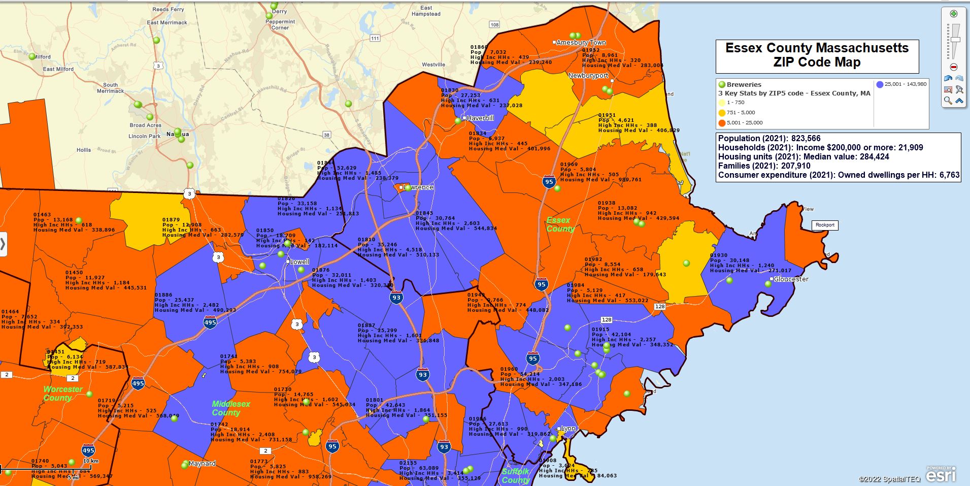
Essex County, MA – ZIP Code Map
MapBusinessOnline ZIP code-related features include:
- The ability to import a simple spreadsheet of ZIP codes into the map application for compelling map visualizations. We often refer to these maps as ZIP code maps.
- The ability to color-code ZIP codes based on imported or demographic data. This process is referred to as ‘heat mapping.’ (In MapBusinessOnline, ‘heat mapping’ is also a feature we offer that shows concentrations of location points by numeric values. )
- Sales territory mapping by ZIP code alignment. Sales territory mapping is a primary solution used by thousands of MapBusinessOnline customers. Sales territory maps are used by all kinds of industries, including construction businesses, franchise organizations, insurance companies, manufacturing concerns, medical systems, retail chains, service industries, and a host of other firms.
- MapBusinessOnline Pro’s ability to create ZIP-to-ZIP origin/destination maps. We call these feature Batch Calculate. It can calculate accurate driving time or distance measurements between all points in one to two datasets. Talk about glorious.
- Summarize demographic data by ZIP code or groups of ZIP codes for use within or outside MapBusinessOnline.
- Search and Purchase Business Listings by ZIP or groups of ZIP codes. These paid-for search results can then be color-coded and exported.
- The use of the ZIP code layer as a map background color-coded by demography or imported user data. I use this powerful feature all the time.
How Can I Export My ZIP Codes Segmented by Territory?
The above subject is a common technical support question from MapBusinessOnline sales territory management users.
Realize that by simply exporting the ZIP code layer from the Data Window view, a user can easily export all ZIP codes. Select the layer and click the Export button on the far right of the Data Window toolbar. Try it.
Accordingly, our development team made the export process operation for exporting all ZIP codes segmented by territory name a very easy-to-accomplish task.
Once you’ve created territories:
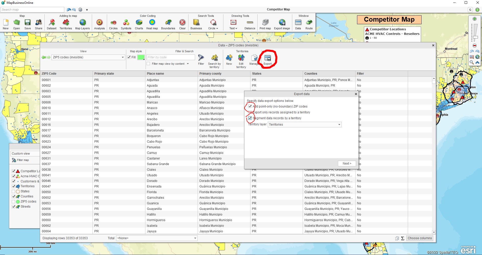
- Open the Data Window.
- Select the ZIP5 Code Map Alignment Layer in the Data Window dropdown. To be clear, you are exporting ZIP codes by Territory, but you must select the ZIP code layer.
- Check all Three Boxes – As you begin the short export process, you will find three checkboxes that you should check off:
- □ Add point-only ZIP codes
- □ Export only records assigned by Territory.
- □ Segment records by Territory.
- Click the Export button on the far right of the Data Window toolbar.
- Save your exported file. The file will export as a comma delimited CSV file.
The user does not need to add a territory column to the ZIP code map view in the Data Window. This simplified export process will add the territory name column to your exported spreadsheet for you. As you can see, the check box option allows the user to include Point Zip codes which means you’ll be exporting all ZIP codes associated with each Territory.
Exporting ZIP Codes Using MapBusinessOnline
MapBusinessOnline users export ZIP codes segmented by Territory for multiple reasons:
- To verify territory coverage areas and make sure there are no gaps.
- To generate sales reports by Territory, franchise, store, or sales rep.
- To clarify franchise territory ZIP code ownership or accountability.
- To create a record of assigned sales territory ZIP codes for franchisee reference.
- To display and track Zone pricing by ZIP code.
Note: Any MapBusinessOnline map layer (City Limits, Counties, Census tracts, and more) can be exported from the Data Window exactly as ZIP codes are exported above.
Further ZIP Code Segmentation
While the Export button from the ZIP code layer is now optimized to segment output by territories, map creators can segment ZIP code, county, or other map layer output by using other data columns.
Use the Choose Columns button to add columns from imported data, the demographic catalog, or other geographic layers into your analysis. Then segment as required and export the resulting spreadsheets to CVS files.
Popular ZIP code and county segmentation themes include:
- Customer segmentation – Segment groups of customers by area, customer type, sales activity, or by-product interest.
- Demographic segmentation – Segment areas by demographic categories such as population or median income levels.
- Calculated Data Columns – Combined columns using Calculated Data Columns in Map and Data. Basically a formula function by map layer.
Note: For advance segmentation across multiple locations at one-time purchase MapBusinessOnline Pro.
ZIP codes offer tremendous value for business mapping users when viewed as the most popular map layer. These mostly tiny jurisdictions are the geographic building blocks of our collective lives. Use them to organize your business mapping visualizations, and you’ll share compelling and informative map projects across your business.
And your peers and constituents will think you are a geo-genius. Not bad for a Map Geek.
_______________________________________________
Discover why over 25,000 business users log into www.MapBusinessOnline.com for their business mapping software and advanced sales territory mapping solution. The best replacement for Microsoft MapPoint happens to be the most affordable.
To access MapBusinessOnline, please register and download the Map App from the website – https://www.mapbusinessonline.com/App-Download.aspx.
After installing the Map App, the MapBusinessOnline launch button will be in the Windows Start Menu or Mac Application folder. Find the MapBusinessOnline folder in the Start Menu scrollbar. Click the folder’s dropdown arrow and choose the MapBusinessOnline option.
The Map App includes the Map Viewer app for free non-subscriber map sharing.
Please read customer reviews or review us at Capterra or g2crowd.
Contact: Geoffrey Ives at geoffives@spatialteq.com or Jason Henderson at jhenderson@spatialteq.com