How to Prepare for Sales Territory Mapping
Cloud-based mapping tools have made sales territory mapping accessible to businesses of all sizes. While some still rely on expensive desktop GIS software, cloud services offer faster performance, real-time updates, and easier team access.
Why Use Sales Territory Mapping?
Mapping your sales territories offers several key advantages:
- Clear Goal Setting: A shared platform to define and present sales goals and targets clearly.
- Balanced Workloads: Customer maps that help balance workloads and plan opportunities effectively.
- Increased Accountability: Trackable performance and shared maps increase accountability for sales reps.
- Team Support: A foundation for sharing sales experiences and supporting team training initiatives.
- New Opportunities: Tools for finding and capitalizing on new market opportunities.
Sales territory mapping helps your team move beyond spreadsheets and adopt a collaborative, location-based strategy. So, how do you get started with sales territory mapping?
Most companies already possess the essentials: customer data, account assignments, and a general understanding of territory boundaries. The next steps involve basic data preparation and using mapping tools to reflect your business's critical elements.
Learn More About Territory Management.
Choose the Right Base Geography
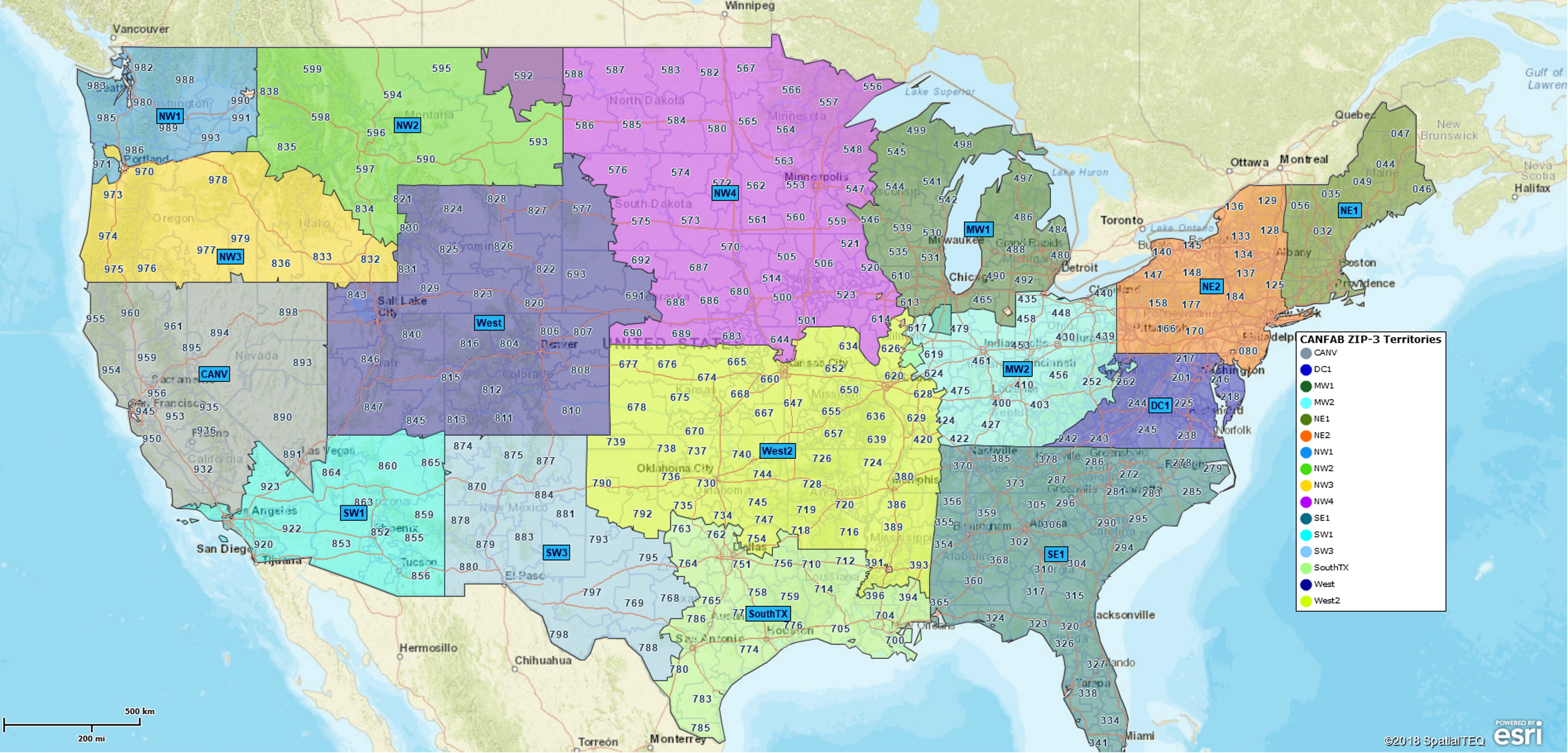
Business mapping tools support common administrative districts like counties and ZIP codes for building sales territories. The right choice depends on your customers' locations:
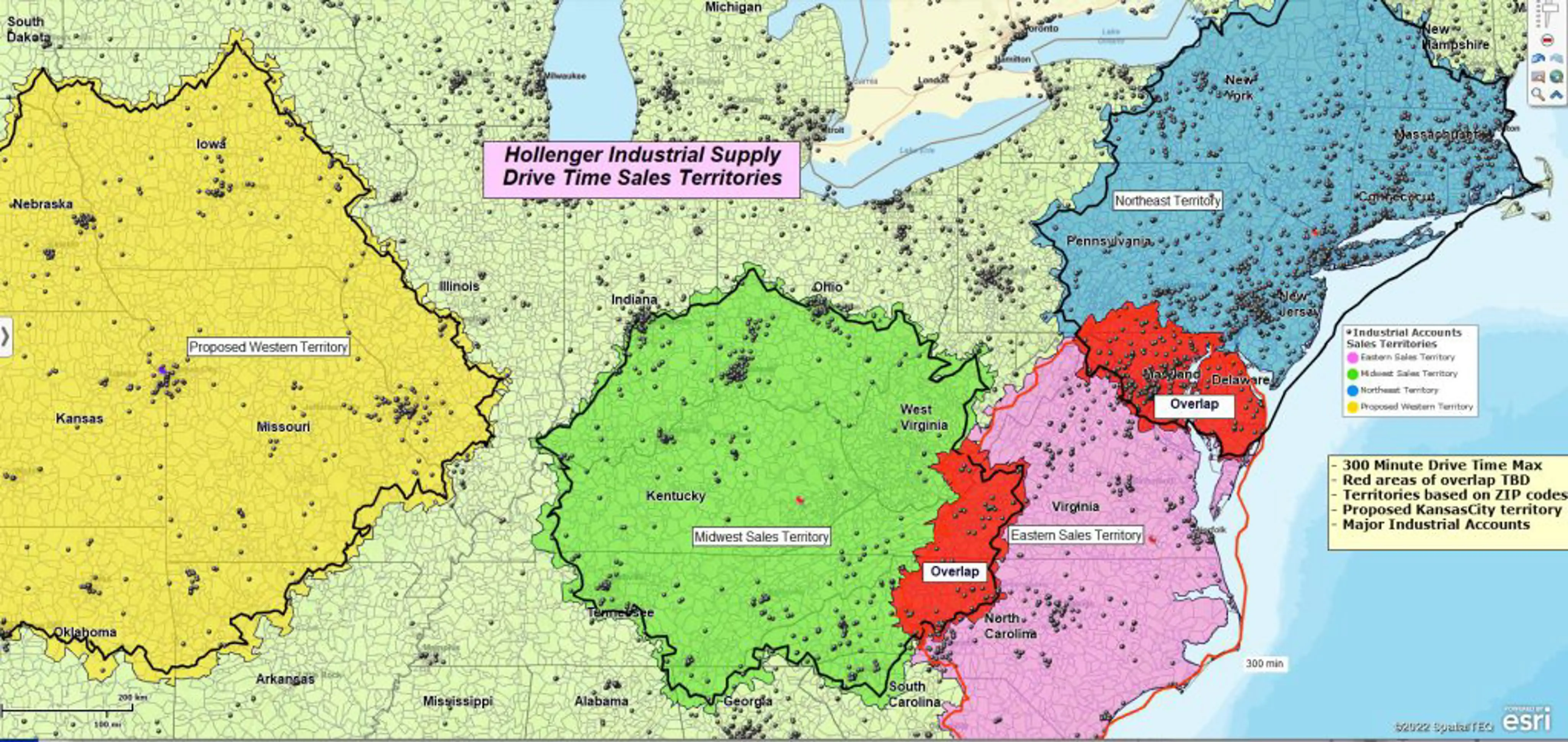
- State-Level Mapping: Best for companies with national coverage and dispersed customers. For example, large industrial suppliers often use states as their base unit for sales territory mapping.
- ZIP Code-Based Mapping: Ideal for dense markets with high activity in urban or suburban areas. This is the most common method used by sales teams for sales territory mapping.
- County or City-Level Mapping: May work well for businesses targeting local governments or city-specific services.
Select a geography that mirrors your business and customer structure.
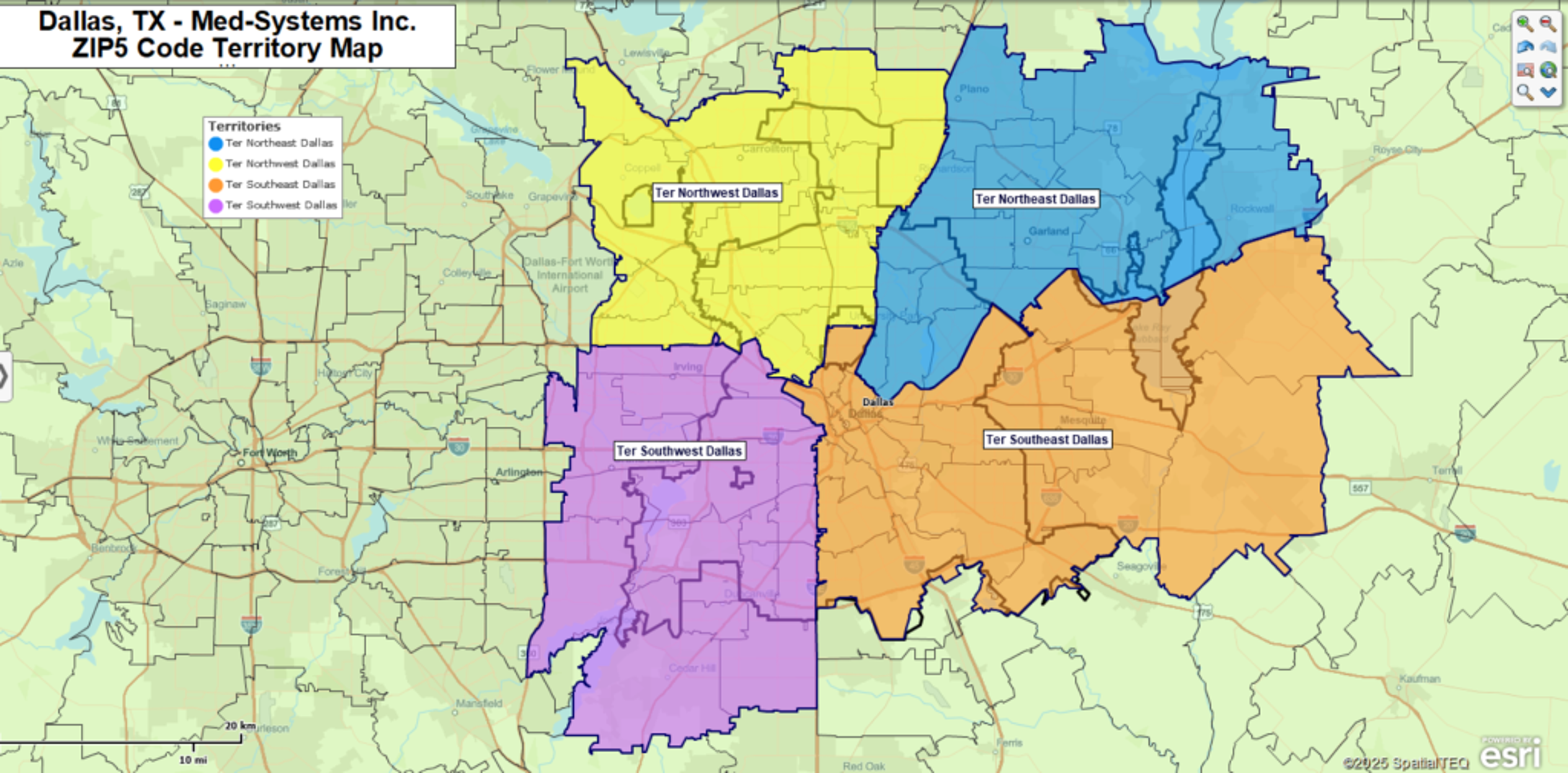
ZIP Codes for Franchise Businesses
Franchise businesses - especially in retail or services - often choose ZIP codes as a base alignment layer. ZIP codes simplify defining and managing sales areas and align well with population data and demographics. This makes them ideal for planning, selling, and measuring performance within sales territories.
Prepare Your Customer Data
You’ll need up-to-date customer data before building your sales territories. Start by requesting the latest list from your CRM administrator or marketing team, including:
- Customer addresses (street, city, state, ZIP)
- Prospective clients or leads
- Any additional resource or partner locations
Ensure you have permission to use this data, as it will form the foundation of your sales map.
Collect Sales Representative Home Locations
Knowing where your sales reps start their day helps create realistic, efficient sales territories. Collect each rep’s home base or regular starting point.
This information is especially useful for travel planning and account assignments. For instance, it might not be practical for a Denver-based rep to regularly drive to customers in Grand Junction. This highlights the importance of considering travel distance when designing sales territory mapping.
Include Competitor Locations
Adding competitor data to your sales map provides a clearer understanding of your company's position. Even listing top players or local competitors can help your team identify challenges and opportunities.
If you don’t have a list, consult your reps. They usually know the competitors in each region.
Import Data into a Business Mapping Application
Once your data is ready, import it into a cloud-based mapping tool like MapBusinessOnline. These platforms allow you to:
- Upload ZIP code lists linked to territory names.
- Draw custom areas using polygon tools.
- Adjust boundaries easily by adding or removing ZIP codes or counties.
Most tools offer both map and table views, which you can use to:
- Visualize customer concentrations.
- Associate territories with sales metrics or demographic data.
- Use color-coding and symbols to highlight key insights.
This simplifies understanding patterns and sharing insights with your team.
Evaluate Your Territory Map: What to Look For
Once your initial sales territories are in place, step back and assess them strategically. Look for these key elements:
- Trends and Anomalies: Noticeable patterns in customer location or account types can reveal hidden opportunities or concerns that spreadsheets might miss.
- New Market Opportunities: Emerging customer segments or industries in previously overlooked regions can guide targeted marketing and sales efforts.
- Territory Overlap: Multiple sales reps working in the same ZIP codes or regions often lead to inefficiencies, duplicate efforts, and commission conflicts. Eliminate these pain points with your map.
- Legacy Account Imbalances: Certain sales reps managing most long-standing accounts can distort performance metrics and take time away from new business acquisition.
- Replicable Patterns: Consistently outperforming territories may share traits - demographics, product demand, rep strategy - that can be applied elsewhere.
Balance the Sales Load
Creating a fair and manageable workload across all sales territories is a crucial outcome of effective territory mapping. Here’s why it matters:
- Motivation: A balanced workload keeps sales reps motivated, engaged, and focused within equitable territories.
- Faster Success for New Hires: Fair territory distribution allows new reps to build early momentum, develop confidence, and contribute meaningfully.
- Fair Reward Distribution: Balanced territories reduce resentment, encourage teamwork, and ensure compensation reflects effort and results—not historical account advantages.
- Better Decisions: Easier tracking, resulting from balanced workloads, leads to better performance evaluation, gap identification, and timely adjustments.
To evaluate your current balance, ask these questions in one-on-one reviews with your reps:
- Are travel distances relatively equal, or are some reps logging far more miles than others?
- Is compensation structured fairly across the team, or are a few reps earning outsized commissions from legacy accounts?
- Are there overlaps where several reps are visiting the same ZIP codes or accounts?
- Are growth opportunities present in all territories, or are new leads being funneled mostly to senior reps?
- Do newer sales team members understand the process and products, or is more training needed?
Use these insights to fine-tune your sales territory design. Balanced territories support fairness, improve team performance, and enhance customer service.
Use Maps to Improve Sales Meetings
Once your sales territory map is established, use it as a visual tool in regular sales meetings. Territory maps can transform meetings into focused, results-driven discussions. Here’s how:
- Performance Reviews: Sales territory maps provide a clear view of who is hitting goals and which areas need attention.
- Knowledge Sharing: Encourage reps to share success stories and lessons learned, uncovering hidden best practices and useful insights.
- Collaboration and Growth: Veteran reps can coach newer team members, while fresh perspectives from newer reps might reveal emerging opportunities.
- Consistent Messaging: Maps ensure everyone stays aligned with priorities, strategies, and resource allocation.
Maps give sales meetings structure and substance, turning generic check-ins into practical working sessions grounded in real-world data.
Reveal New Market Opportunities with Mapping
As your sales territory map evolves with real-time data and field feedback, it becomes a powerful tool for identifying growth opportunities. A dynamic sales territory map can:
- Expose Underdeveloped Areas: Discover regions with little to no sales activity that show signs of demand or interest.
- Blend Internal and External Data: Layer customer data with external sources - like demographic trends or market forecasts - to reveal promising targets.
- Shift Attention from Outdated Accounts: Highlight when legacy accounts no longer provide growth and when to shift focus.
- Guide Long-Term Strategy: Your sales territory map becomes a living document that evolves with your business, continuously refining territory boundaries and resource planning.
Final Thoughts
Sales territory mapping isn’t just about drawing lines - it’s about building smarter, more strategic sales operations. With good data, thoughtful planning, and the right tools, your team will have what it needs to succeed.
A little preparation now can set the stage for stronger sales and smarter growth.


